[Saturday Trips June 2, 2017] [Sunday Trips June 3, 2017]
Meet by 11:45 am at at the parking lot in front of the BLM and USFS ranger stations and depart as soon after as possible. Trips return to Prineville approximately 4-4:30 pm.
Ticks and rattlesnakes are a possibility (rarely seen) on most hikes, so long pants and sturdy hiking shoes are recommended. Carry plenty of water.
Note: Approximate drive times (add gas or restroom breaks to time) from Prineville: Eugene, Portland and Salem are all approximately a 3 hour drive. Burns is about a 2:10 drive. The Dalles is about a 2:20 drive. Pendleton is about 4:20. Klamath Falls is about 3:05. Roseburgand Medford are about 4 hrs. Newport is about 4:10. Astoria is about 4:40. Check before you leave home for road construction delays enroute.
Click the trip name to find longer descriptions of hike destinations, maps, photos, access info and plant lists.
1) Baneberry Trail (Ochoco National Forest): Leader - Susan Saul.
This easy loop trail begins in a moist meadow filled with California false hellebore (Veratrum californicum var. californicum) and the path is lined with masses of broadleaf lupine (Lupinus latifolius var. latifolius). The loop trail then goes through a beautiful forest of California white fir (Abies concolor x grandis) that is mostly shaded, making it perfect for a hot day. The understory includes lots of the trail’s namesake baneberry (Actaea rubra), bead lily (Clintonia uniflora) and numerous other forbs and shrubs of the forest floor. The loop goes around a stream drainage that includes moisture-loving species like Columbia monkshood (Aconitum columbianum ssp. columbianum) and common monkeyflower (Erythranthe guttata). If time allows, we will also walk around the Independent Mine site which still has miners’ cabins and a former cinnabar mine. Easy hike, although the trail is not always well maintained. One mile loop, 200' elevation gain. Driving distance: About 30 miles (45 min) one-way drive. No restrooms at trailhead.
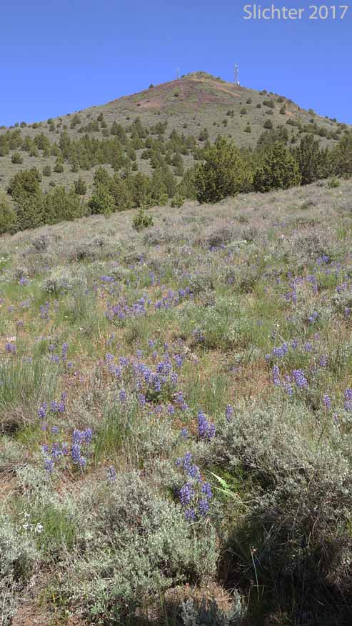
2) Chimney Rock (BLM): Leader - Marilynne Keyser (Friends and Neighbors of the Deschutes Canyon Area). Assistant Leader - Willow Elliott
This easy, round-trip hike is less than 3 miles (500' elevation gain) and follows a well-maintained trail from the upper Crooked River below Bowman Dam to the geological marvel called Chimney Rock on the canyon rim. We will be going slowly and stopping often to examine the native plants we encounter and the incredible vistas along the rim. This hike will start at the Chimney Rock trailhead located across the road from the Chimney Rock Campground on the Wild and Scenic Crooked River. We will be hiking through several native plant communities, including the talus slope and the lithosol. We will reserve time at the end to explore the riparian zone in the Chimney Rock campground. Driving distance: 16 miles (25 min.) one way on paved roads. Vault toilet in campground opposite trailhead.
Expect to find stiff milkvetch (Astragalus conjunctus var. conjunctus), threadstalk milkvetch (Astragalus filipes), freckled milkvetch (Astragalus lentiginosus), low hawksbeard (Crepis modocensis), western prairie clover (Dalea ornata), threadleaf fleabane (Erigeron filifolius), yellow desert daisy (Erigeron linearis), spiny hopsage (Grayia spinosa), bush oceanspray (Holodiscus microphyllus), bitterroot (Lewisia rediviva), silky lupine (Lupinus sericeus), lowly penstemon (Penstemon humilis), purple sage (Salvia dorrii), mountain snowberry (Symphoricarpos oreophilus), showy townsendia (Townsendia florifer).
3) Gray Butte (Crooked River National Grasslands): Leader - Roger Brewer
Join Crooked River National Grassland botanist Jennifer Carson for a moderate hike through a typical central Oregon shrub-steppe habitat around Gray Butte west of Prineville. We'll start from the McCoin Orchard Trailhead and hike a trail that climbs slowly towards the scenic Austin Creson Viewpoint (up to 3.8 miles RT, 800' gain). Driving distance: About 20 miles (40 min) one way. Subaru Outback or equivalent vehicle recommended.
Expect to find stiff milkvetch (Astragalus conjunctus var. conjunctus), Carey's balsamroot (Balsamorhiza careyana), Peck's paintbrush (Castilleja peckiana), bushy birdbeak (Cordylanthus ramosus), fennel cymopterus (Cymopterus terebinthinus var. foeniculaceus), John Day cinquefoil (Drymocallis campanulatum), threadleaf fleabane (Erigeron filifolius), yellow desert daisy (Erigeron linearis), Goose Lake wild buckwheat (Eriogonum strictum var. anserinum), Cusick's elkweed (Frasera cusickii), perhaps some early bitterroot (Lewisia rediviva), cous (Lomatium cous), Donnell's lomatium (Lomatium donnellii), broad-sheath desert parsley (Lomatium vaginatum), silvery lupine (Lupinus argenteus var. argenteus), lowly penstemon (Penstemon humilis), and blue dicks (Triteleia grandiflora).
4) Big Summit Prairie (Ochoco National Forest): Leader - Jill Welborn (Botanist - Ochoco NF), Assistant - Nancy Chapman.
Paulina District (Ochoco NF) botanist Jill Wellborn will lead an auto tour of several scabland and wetlands sites along Forest Road 42 in southwestern Big Summit Prairie. Short, easy walks over fairly flat but rocky ground will get people close to the plants of these habitats. Driving distance: About 40 mile drive (50 minutes to first stop) one way, mostly on paved roads.
We'll hope to find tapertip onion (Allium accuminatum), Tolmie's onion (Allium tolmiei) american bistort (Bistorta bistortoides), small camas (Camassia quamash ssp. breviflora), wavyleaf paintbrush (Castilleja applegatei var. pinetorum), Cusick's paintbrush (Castileja cusickii), meadow larkspur (Delphinium depauperatum), dark-throat shooting star (Dodecatheon pulchellum var. monanthum), Rydberg's sticky geranium (Geranium viscosissimum var. incisum), prairie smoke (Geum triflorum), western blue flag (Iris missouriensis), slender woodland star (Lithophragma tenellum), slender-fruited desert parsley (Lomatium leptocarpum), and perhaps som Brown's peony (Paeonia brownii) or late-blooming white-headed wyethia (Wyethia helianthoides).
5) Coffer (Bella) Ranch (Deschutes Land Trust): Leader - Carol Moorehead & DLT Assistant
Join the Deschutes Land Trust and Carol Moorehead for a wildflower hike around Coffer Ranch, a conserved private ranch outside of Prineville. We’ll hike along Mill Creek and enjoy scenic views of unique rock formations while learning more about the springs and wetlands the ranch protects. Then, we’ll head up into the hills to search for a myriad of native wildflowers including native grasses, phlox, prairie star, balsamroot, and bitterroot. This strenuous hike (due to some cross country hiking over irregular ground and slopes) follows old roads although there may a couple sections of steeper cross country hiking, up to 4.5 miles with 300' elevation gain. The Deschutes Land Trust asks that participants wear long pants & sturdy hiking shoes, and bring plenty of water. Driving Distance: About 15 miles (20 min) one way on paved roads, and perhaps a short section of good gravel road.
* Please print, fill out and bring Deschutes Land Trust's waiver with you to the meeting site.
Expect to find: pale agoseris (Agoseris glauca), Tolmie's onion (Allium tolmiei), arrowleaf balsamroot (Balsamorhiza sagittata), rough eyelashweed (Blepharipappus scaber), diamond clarkia (Clarkia rhomboidea), dustymaidens (Chaenactis douglasii), yellow desert daisy (Erigeron linearis), shaggy daisy (Erigeron pumilus), sulfur flower buckwheat (Eriogonum umbellatum), western wallflower (Erysimum capitatum), prairie smoke (Geum triflorum), roundleaf alumroot (Heuchera cylindrica var. alpina), Scouler's hawkweed (Hieracium scouleri), western blue flag (Iris missouriensis), bitterroot (Lewisia rediviva), wild blue flax (Linum lewisii), slender woodland star (Lithophragma tenellum), silvery lupine (Lupinus argenteus), lowly penstemon (Penstemon humilis), narrowleaf phacelia (Phacelia linearis), spreading phlox (Phlox diffusa), woolly goldenweed (Stenotus lanuginosus), showy townsendia (Townsendia florifer), panicled deathcamas (Toxicodendron paniculatum).
6) Ponderosa Loop Trail #810 at Bandit Springs: Leader - Paul Slichter
This is an easy hike along the Ponderosa Loop Trail (a x-country ski trail) for about 2 miles with about 100' elevation gain, visiting several wet meadows and plenty of open, upland coniferous forest. Driving distance: 30 miles (35 min) one way, all on pavement. Parking area at Bandit Springs is an oft used rest area on US 26. Take valuables with you, keep car contents hidden, or check in early at your hotel.
Expect to find Tolmie's onion (Allium tolmiei), heartleaf arnica (Arnica cordifolia), Wyoming paintbrush (Castilleja linariifolia), common paintbrush (Castilleja miniata var. miniata), bead lily (Clintonia uniflora), an early mountain lady slipper (Cypripedium montanum), shrubby cinquefoil (Dasiphora fruticosa), upland larkspur (Delphinium nuttallianum), valley cinquefoil (Drymocallis convallaria), Montana sticky cinquefoil (Drymocallis glandulosa var. reflexa), Rydberg's geranium (Geranium viscosissimum var. incisum), Rocky Mt. sunflower (Helianthella uniflora), small-flowered horkelia (Horkelia fusca ssp. parviflora), western blue flag (Iris missouriensis), Lanszwert's peavine (Lathyrus lanszwertii var. lanszwertii), whiskerbrush (Leptosiphon ciliatus), velvet lupine (Lupinus leucophyllus), Oregon saxifrage (Micranthes oregana), three-toothed mitrewort (Mitella trifida), Rydberg's penstemon (Penstemon rydbergii var. oreocharis), long-spurred bog orchid (Platanthera dilatata var. leucostachys). We'll also keep an eye out for early-blooming mountain lady slippers (Cypripedium montanum).
7) Pine Ridge: Leader - Stu Garrett
Pine Ridge is on public land 15 miles northwest of Prineville and is managed by the Crooked River National Grasslands. It is the NE rim of the Crooked River Caldera and we will discuss this geologic feature. Pine Ridge has some of the best remnant native grasslands in central Oregon and also has a superb wildflower display in the spring. Raptors nest on its cliffs. We will also vist the McCoin Homestead orchard and overlook, the double exclosure, Skull Hollow, the Lone Pine Valley and the medusa-head week control project. We will hike 2-3 miles on the lower slopes of the ridge and may to to the top with an elevation gain of 800'. Hiking is off-trail with moderate to challenging footing if we summit. Good shoes and poles are recommended. Driving distance: About 20 miles (40 min) one way. Subaru Outback or equivalent vehicle recommended.
Expect to find stiff milkvetch (Astragalus conjunctus var. conjunctus), Carey's balsamroot (Balsamorhiza careyana), Peck's paintbrush (Castilleja peckiana), bushy birdbeak (Cordylanthus ramosus), fennel cymopterus (Cymopterus terebinthinus var. foeniculaceus), John Day cinquefoil (Drymocallis campanulatum), threadleaf fleabane (Erigeron filifolius), yellow desert daisy (Erigeron linearis), Goose Lake wild buckwheat (Eriogonum strictum var. anserinum), Cusick's elkweed (Frasera cusickii), perhaps some early bitterroot (Lewisia rediviva), cous (Lomatium cous), Donnell's lomatium (Lomatium donnellii), broad-sheath desert parsley (Lomatium vaginatum), silvery lupine (Lupinus argenteus var. argenteus), lowly penstemon (Penstemon humilis), and blue dicks (Triteleia grandiflora) and numerous native grass species.
8) Meadows Around the Twin Pillars Trailhead: Leader - Ron Klump
We will spend several hours exploring the vernally moist meadows around and near the Twin Pillars North trailhead. If there is time, we may walk the first portion of the Twin Pillars Trail into the upper portion of the Mill Creek Wilderness.
Expect to find: upland larkspur (Delphinium nuttallianum), desert shootingstar (Dodecatheon conjugens), false solomon seal (Maianthemum racemosum ssp. amplexicaule), nodding microseris (Microseris nutans), black elderberry (Sambucus racemosa var. melanocarpa), western groundsel (Senecio integerrimus var. exaltatus), Oregon checkermallow (Sidalcea oregana), claspleaf twisted-stalk (Streptopus amplexifolius), northern bog violet (Viola nephrophylla), white-headed wyethia (Wyethia helianthoides). I will add a more comprehensive, prospective plant list for the trailhead meadows once I can get to the trailhead for an initial exploration by mid-May 2018.
Driving Distance: About 30 paved miles oneway with about half a mile of unimproved road. Driving time is a little over an hour each way.