[Friday Trips June 1, 2017] [Saturday Trips June 2, 2017]
Meet by 8:50 am at the parking lot in front of the BLM and USFS ranger stations and depart as soon thereafter as possible. Trips should complete at approximately 2-2:30 pm.
Ticks and rattlesnakes are a possibility (rarely seen) on most hikes, so long pants and sturdy hiking shoes are recommended. Carry plenty of water. Note: Drivers for the Steelhead Falls hike may not be returning to Prineville. The other Sunday hikes return through Prineville.
Note: Approximate drive times (add gas or restroom breaks to time) from Prineville: Eugene, Portland and Salem are all approximately a 3 hour drive. Burns is about a 2:10 drive. The Dalles is about a 2:20 drive. Pendleton is about 4:20. Klamath Falls is about 3:05. Roseburg and Medford are about 4 hrs. Newport is about 4:10. Astoria is about 4:40. Add additional time for rest stops or road side photo ops.
Click the trip name to find longer descriptions of hike destinations, maps, photos, access info and plant lists.
* *** Sunday's NPSO Field Trips are on a first come, first served basis. Sorry we don't have more Sunday trips, but we just don't have enough leaders willing to lead Sunday trips.......
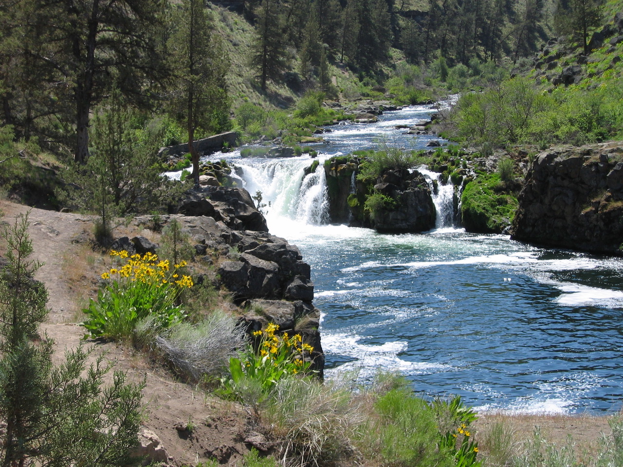
1) Steelhead Falls & Crooked River Ranch Native Plant Interpretive Garden: Leader - Marilynne Keyser (Friends and Neighbors of the Deschutes Canyon Area) Assistant - Willow Elliott
We will spend 45 minutes at the Crooked River Ranch Native Plant Interpretive Garden. This is the largest native plant garden in Central Oregon, hosting 40 species of native plants common to the sagebrush steppe in the Middle Deschutes Canyon area. Plants are labeled, and a checklist will be provided. The garden was created by the Friends and Neighbors of the Deschutes Canyon Area (FANs) under the direction of hike leader and NPSO member Marilynne Keyser.
We will caravan across Crooked River Ranch to the Steelhead Falls trailhead in the Deschutes Canyon-Steelhead Falls Wilderness Study Area. This moderately difficult loop hike (3 miles, 700' gain on the return) will begin at the trailhead parking lot with a steep ascent to the canyon rim. We will hike north along the rim, viewing the falls from above, continuing along the rim to a steep and gravelly trail back down to the river. We will finish by hiking upriver past the falls to the trailhead parking lot. The hike will focus on the native plant communities that are specific to the unique zones they inhabit—the talus slope, the lithosol, and the riparian. However, the incredible cascade views from the rim, the geological marvels, and Steelhead Falls itself will also be highlights. Driving distance: About 42 paved miles one way (50 min.), and an additional 5-6 miles to the Steelhead Falls Trailhead.Steelhead Falls Plant List
2) Ponderosa Loop Trail #810 at Bandit Springs & Mt. Lady Slippers: Leader - Roger Brewer
This is an easy hike along the Ponderosa Loop Trail (a x-country ski trail) for about 2 miles with about 100' elevation gain, visiting several wet meadows and plenty of open, upland coniferous forest. Driving distance: 65 miles (35 min to first stop) round trip, with about 6 miles (20 min) of that consisting of good gravel road to view the lady slippers. The parking area at Bandit Springs is an oft used rest area on US 26. Take valuables with you, keep car contents hidden, or have your hotel store your luggage in secure area.
Expect to find Tolmie's onion (Allium tolmiei), heartleaf arnica (Arnica cordifolia), Wyoming paintbrush (Castilleja linariifolia), common paintbrush (Castilleja miniata var. miniata), bead lily (Clintonia uniflora), an early mountain lady slipper (Cypripedium montanum), shrubby cinquefoil (Dasiphora fruticosa), upland larkspur (Delphinium nuttallianum), valley cinquefoil (Drymocallis convallaria), Montana sticky cinquefoil (Drymocallis glandulosa var. reflexa), Rydberg's geranium (Geranium viscosissimum var. incisum), Rocky Mt. sunflower (Helianthella uniflora), small-flowered horkelia (Horkelia fusca ssp. parviflora), western blue flag (Iris missouriensis), Lanszwert's peavine (Lathyrus lanszwertii var. lanszwertii), whiskerbrush (Leptosiphon ciliatus), velvet lupine (Lupinus leucophyllus), Oregon saxifrage (Micranthes oregana), threetoothed mitrewort (Mitella trifida), Rydberg's penstemon (Penstemon rydbergii var. oreocharis), long-spurred bog orchid (Platanthera dilatata var. leucostachys).
If time permits, we'll drive to a site that should have blooming mountain lady slippers (Cypripedium montanum) and perhaps some Brown's peonies (Paeonia brownii). About 0.2 miles RT with 50' elevation gain.
3) Juniper Hills Preserve: Leader - Stu Garrett, Assistant - Cindy Roche (Pacific Northwest grass specialist ) & Brooke Gray ? (Juniper Hills Preserve Steward)
The Juniper Hills Preserve is a gem in the heart of central Oregon about 30 miles east of Prineville. It has a diversity of ecosystems including riparian areas along the Crooked River and the entire drainage of Lost Creek. Sagebrush steppe, juniper woodlands, and ponderosa pine forests make up the rest of the 14,000 acre holding. Over the last 20 years the Nature Conservancy has improved riparian areas, started prescribed burns to thin junipers, and restored upland plant communities. The wildflowers can be spectacular in June. As one of the early ranches in central Oregon there is a strong early settler history along with much Native American use. Anyone interested in geology will be fascinated by the unusual and colorful John Day and Clarno Formations on the Preserve. We will do 3 hikes over less than 3 miles total, walking mostly on flat terrain. No pets. Driving distance: About 35 miles (50 min) one way on paved roads with a few miles of good gravel roads in the preserve.
Expect to find Thurber's needlegrass (Achnatherum thurberianum), Indian ricegrass (Achnatherum hymenoides), basin wildrye (Leymus cinereus), bluebunch wheatgrass (Pseudoroegneria spicata), John Day penstemon (Penstemon eriantherus var. argillosus), showy penstemon (Penstemon speciosus), threadstalk milkvetch (Astragalus filipes), woollypod milkvetch (Astragalus purshii), broadsheath desert parsley (Lomatium vaginatum), bitterroot (Lewisia rediviva), mountain mahogany (Cercocarpus ledifolius), blue flax (Linum lewisii), harsh paintbrush (Castilleja hispida), purple sage (Salvia dorii), threadleaf fleabane (Erigeron filifolius), showy townsendia (Townsendia florifer) and many others.
4) Big Summit Prairie: Leader - Paul Slichter, Assistant - Susan Saul.
We'll visit scabland and riparian meadow sites along the north and east side of Big Summit Prairie, including Indian Creek and several sites near the old Cold Springs Guard Station, then loop back along the south side of Big Summit Prairie. Several roadside stops with short trips with little elevation gain away from vehicles. Vehicle contents should be safe and participants can depart when they need to. The leader can stay into mid-late afternoon if needed. Driving distance: Up to 96 miles RT.
We'll hope to find tapertip onion (Allium accuminatum), Tolmie's onion (Allium tolmiei), american bistort (Bistorta bistortoides), small camas (Camassia quamash ssp. breviflora), wavyleaf paintbrush (Castilleja applegatei var. pinetorum), Cusick's paintbrush (Castilleja cusickii), meadow larkspur (Delphinium depauperatum), dark-throat shooting star (Dodecatheon pulchellum var. monanthum), Rydberg's sticky geranium (Geranium viscosissimum var. incisum), prairie smoke (Geum triflorum), western blue flag (Iris missouriensis), slender woodland star (Lithophragma tenellum), slender-fruited desert parsley (Lomatium leptocarpum), and perhaps some Brown's peony (Paeonia brownii), late-blooming white-headed wyethia (Wyethia helianthoides) or pre-bloom Peck's mariposa (Calochortus longebarbatus var. peckii). About 80 mile drive RT, 50 minutes to first stop.
5) Chimney Rock (BLM): Leader - Ron Klump
This easy, round-trip hike is less than 3 miles (500' elevation gain) and follows a well-maintained trail from the upper Crooked River below Bowman Dam to the geological marvel called Chimney Rock on the canyon rim. We will be going slowly and stopping often to examine the native plants we encounter and the incredible vistas along the rim. This hike will start at the Chimney Rock trailhead located across the road from the Chimney Rock Campground on the Wild and Scenic Crooked River. We will be hiking through several native plant communities, including the talus slope and the lithosol. We will reserve time at the end to explore the riparian zone in the Chimney Rock campground. Driving distance: 16 miles (25 min.) one way on paved roads. Vault toilet in campground opposite trailhead.
Expect to find stiff milkvetch (Astragalus conjunctus var. conjunctus), threadstalk milkvetch (Astragalus filipes), freckled milkvetch (Astragalus lentiginosus), low hawksbeard (Crepis modocensis), western prairie clover (Dalea ornata), threadleaf fleabane (Erigeron filifolius), yellow desert daisy (Erigeron linearis), spiny hopsage (Grayia spinosa), bush oceanspray (Holodiscus microphyllus), bitterroot (Lewisia rediviva), silky lupine (Lupinus sericeus), lowly penstemon (Penstemon humilis), purple sage (Salvia dorrii), mountain snowberry (Symphoricarpos oreophilus), showy townsendia (Townsendia florifer).
6) Steins Pillar Trail: Leader - Linda Vorobik
This moderate hike of 4.1 miles, 900' total elevation gain (high point in the middle) passes through rock outcrops, open balds and forested slopes before descending to the base of the 350' high Steins Pillar. If time allows, we'll drive to the nearby Brennan Palisades and make roadside stops in search of other area wildflowers. Driving distance: 18 miles (30 min) one way, with additional mileage if we have time for roadside botany afterwards. Roads are mostly paved with several miles of good but sometimes bumpy gravel roadway.
Expect to find: green-leaf manzanita (Arctostaphylos patula), heartleaf arnica (Arnica cordifolia), rough eyelashweed (Blepharipappus scaber), wavyleaf paintbrush (Castilleja applegatei var. pinetorum), diamond clarkia (Clarkia rhomboidea), tapertip hawksbeard (Crepis acuminata), valley cinquefoil (Drymocallis convallaria), yellow desert daisy (Erigeron linearis), northern buckwheat (Eriogonum compositum), strict buckwheat (Eriogonum strictum var. anserinum), modoc sulfur flower buckwheat (Eriogonum umbellatum var. modocense), mission bells (Fritillaria atropurpurea), prairie smoke (Geum triflorum), Rocky Mt. sunflower (Helianthella uniflora), roundleaf alumroot (Heuchera cylindrica var. alpina), Scouler's hawkweed (Hieracium scouleri), false solomon's seal (Maianthemum racemosum), woolly groundsel (Packera cana), hotrock penstemon (Penstemon deustus var. variabilis), shrubby penstemon (Penstemon fruticosus var. fruticosus), lowly penstemon (Penstemon humilis), spreading phlox (Phlox diffusa), juniper mistletoe (Phoradendron juniperinum), roughfruit fairybells (Prosartes trachycarpa) and Douglas' catchfly (Silene douglasii).
7) Self-guided Field Trips: Ask questions of other trip participants during the Friday and Saturday night programs to get suggestions on where to do a self-guided field trip on Sunday, or stay an extra couple of days to more fully explore the region! Individuals or small groups may be able to cover more ground than a large group moving at botanical speed, which makes longer hikes (like Lookout Mt., Pine Mt., the Badlands Wilderness, the Maury Mts) more doable!
Shorter Trips (several hours to half a day) That You Can Do On Your Own
a) Winter Creek Restoration & Nursery
Visit the nursery during this self-guided trip to view a native plant nursery. The nursery will also be open for NPSO Annual Meeting participants who wish to visit and purchase high desert plants after their Sunday morning trips conclude. More specific information to follow once they open in the spring.
Wintercreek Nursery has been providing locally grown high desert plants to customers in the Bend-Redmond area for more than 2 decades. Wintercreek Restoration & Nursery website.
c) Chimney Rock Trail (BLM)
d) Rimrock Springs - A nice hour or two stop along a loop trail off US 26 between Madras and Prineville. It's a suitable stop during your drive to or from the 2018 NPSO Annual Meeting.
e) Deschutes Land Trust - Some of the DLT properties are suitable for shorter visits and many are located west of the Deschutes River, convenient for participants heading west. Check out their website for trip ideas.
Longer Trips (more than half a day) That You Can Do on Your Own - Suitable for participants wishing to extend their stays or who have shorter drives home Sunday evening.
a) Lookout Mountain - Individuals or small groups can do this much more quickly (within 4-5 hours on the ground) than a large group. We recommend the Mother Lode Trail #808A for quickest access to the summit. By the time of the 2018 NPSO Annual Meeting, we should know the condition of the Independent Mine Trail #808 which accesses an area of 1000s of brown's peony (Paeonia brownii) and which provides a longer access to the summit of Lookout Mountain and an 8 mile hike by returning on the Mother Lode Trail #808A.
b) Line Butte Trail #807 - If you are staying an extra night, this long hike to South Point on the south rim of Lookout Mountain provides plenty of solitude and passes through several habitats providing a different flora than you'd see by hiking the north side of Lookout Mt.
c) Friends and Neighbors of the Deschutes Canyon Area can provide info and directions to several hikes into the Middle Deschutes River, Lower Crooked River and Lower Whychus Creek. Click the link to visit their website.
d) Maury Mts. - A nice drive route if you are arriving a day or two early or staying an extra night.
e) Pine Mountain Observatory ridgetop - A nice drive route if you are arriving a day or two early or staying an extra night.
f) Painted Hills (John Day Fossil Beds National Monument)
g) Thomas Condon Paleontology Center (John Day Fossil Beds National Monument)
g) Spanish Peak - Located at the east end of the Ochoco National Forest, the access road to the top affords a different flora than the western end of the forest. Read the trip description in the link for hike suggestions. The first mile of the access road is rough but very doable in Subaru or equivalent vehicles. If this was closer to Prineville, we'd have definitely included it as one of our Saturday field trips due to the different flora and marvelous views east to the Aldrich, Greenhorn and Strawberry Mountains.
h) Rock Creek via the Ochoco Mountain Trail #823 - Located along the western edge of Spanish Peak, this is a full day trip from Prineville. Check with the Ochoco National Forest to confirm that the trail from Potter Meadows has been logged out at least down to Waterman's Ditch before you go on this one.
i) Malheur National Forest and the Strawberry Mountains - This is an idea for adventurous types who wish to spend several extra days botanizing in central Oregon. This would mean finding accomodations in John Day, OR or surrounding towns, or camping at one of many campgrounds, including at those in Logan Valley.
j) Steens Mountain: From Prineville, you are only about a 4 hour drive (plus time to restock provisions or get gas) from French Glen at the western base of Steens Mountain!