John Day Fossil Beds National Monument
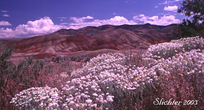
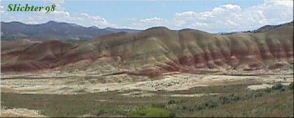
The Painted Hills are colorful remnants of ancient eruptions of the Cascade volcanoes roughly 30 million years ago. The resulting colorful layers of yellow, tan, red and black have been repeatedly photographed and have often graced magazine covers or calendars for many decades. Because the soil contains different minerals, and the environment is so harsh (dry and very sunny), the Painted Hills have a number of unique species (several of which are listed below).
The entrance road is fairly weedy. If you stop occasionally and explore on foot, you may find John Day chaenactis (Chaenactis nevii), western prairie clover (Dalea ornata), golden spiderflower (Cleome platycarpa), yellow-haired paintbrush (Castilleja xanthotricha), orange globemallow (Sphaeralcea munroana), shaggy fleabane (Erigeron pumilus), Cusick's sunflower (Helianthus cusickii) and others. Restrict your foot travel to roadsides, trails, or streambeds as foot prints have a tendancy to last for long periods of time here (especially when the ground is wet)! What you find in bloom and in what quantity depends on the time from the previous rain, and to some extent how late in the spring you are visiting. Bloom can begin and is usually most abundant in mid-May and can extend into early July in wetter years. The Painted Hills Overlook provides a great view of some of the geological formations, and in good weather, is the start of the trail to Carroll Rim (on the north side of the access road). This climbs 380' in elevation over 0.8 miles to scenic views across the entire monument. I haven't done this hike so I don't know what might bloom up here. The 0.2 mile Painted Cove Trail further along the monument road has a number of plants that like the dry clay soils, including some buckwheats.
Painted Hills Unit: Information provide by the John Day Fossil Beds National Monument
From Prineville, OR: Drive east along US Highway 26 before reaching the access road for the Painted Hills between mileposts 62 and 63 (approximately 4 miles west of Mitchell, Or.). Turn right (north) onto Burnt Ranch Rd and proceed for 6 miles. Follow the signs for the Painted Hills, and turn left onto Bear Creek Rd. After a short distance, you will find a picnic area with water and restrooms on the left. Pick up a map of the area here. Proceed along the road into the monument.
From John Day, OR: Drive west along US Highway 26 for about two hours, proceeding past the John Day River and eventually reaching Mitchell, OR. Drive west from Mitchell along US 26 for about 4 miles before turning right (north) onto Burnt Ranch Rd. Proceed north on this road before following the signs to the monument by turning onto Bear Creek Rd.
From Fossil, OR: Drive south and uphill along Oregon Highway 19. After crossing a wooded pass, descend while following Highway 19 in a generally southeasterly direction. After a few miles you will come across the paved Rowe Creek Road which turns sharply to the right (west) from the highway. The sign should also say Twickenham. Shelton Wayside County Park is about another mile further down the highway, so if you reach that, turn around and drive back the way you came. Rowe Creek Road winds through the forest before descending to Twickenham, eventually passing through broad hay fields and cattle pasture. Twickenham is more a community of houses that are spread out over an area of several square miles rather than a small town. Cross the John Day on the bridge and turn west onto South Twickenham Road (also called Twickenham-Bridge Creek Cutoff Road) which begins as a paved road but soon becomes a dusty road. After about 10 minutes you leave the small farms behind and begin a gentle climb uphill into sagebrush country along the northern edge of Sutton Mt. The road begins to turn southwest and after about 10 miles or so you will come to a junction. The signed road to the right (north) descends back to the John Day River at a BLM boat ramp known as Priest Hole with pit toilets and a few rocky campsites. Take the left fork onto Burnt Ranch Road and follow it 3-4 miles to the signed entrance to the Painted Hills on the west side of the road.
Partial Flora for the Painted Hills Unit: John Day Fossil Beds National Monument
April 8, 2007: John Day Fossil Beds National Monument: Painted Hills Unit
May 1, 2004: John Day Fossil Beds National Monument: Painted Hills Unit
May 24, 1998: John Day Fossil Beds National Monument: Painted Hills Unit
May 24, 1998: Vicinity of Mitchell, Or/ US 26 from Mitchell to the John Day River/ Oregon 19 from US 26 to Service Creek, OR.
You can also find a more substantial plant list on the federal government website for national parks and national monuments.