[2025] [2024] [2023] [2022] [2021] [2020] [2019] [2018] [2017] [2016] [2015] [2014] [2013] [2012] [2010] [2009] [2008][2007] [2006] [2005] [2004] [2003] [2002] [2001] [2000 and Before]
I am currently spending time hiking and making plant lists for those trails and cross country routes that aren't well represented in the Columbia River and Klickitat River Gorges this season, so if you don't see your favorite hike here, please check the lists from previous years above to see what you'd see along those hikes. Comprehensive plant lists for a number of hikes in the Columbia River Gorge (Look under the state and county they are found in.) can be found at http://science.halleyhosting.com/nature/bloomtime/lists/plantlists.html .
December 22, 2011: Washington Highway SR14 between Highway 97 and Rock Creek - Several dozen gray rabbitbrush (Ericameria nauseosa) were observed still in bloom. Most were past there peak bloom, but a few were still in full bloom. It was too cold (mid 30s) for pollinators, but a number of pollinators were observed on Dec. 21 further west near Catherine Creek, so it is possible that the flowers could still be pollinated and produce seed, especially with warmer weather expected after December 26. I should point out that a few common mulleins (Verbascum thapsus) were observed in bloom too.
December 21, 2011: Rowland Lake and The Labyrinth and Coyote Wall - A few frazzled Columbia tickseed (Coreopsis atkinsoniana) were observed trying to bloom along the shoreline of Rowland Lake between the Labyrinth and Catherine Creek. A number of pollinators were evident on this sunny day as well as the resident population of western bluebirds which resides here all winter.
December 10, 2011: Columbia River Shoreline East of the mouth of the Sandy River - A foggy day with the shoreline covered with patches of ice and hoar frost. A few Columbia River Wormwood (Artemisia lindleyana) were observed trying to bloom, with more in bud. A few frazzled Columbia tickseed (Coreopsis atkinsoniana) and a few orange sneezeweeds (Helenium autumnale) were also observed trying to bloom in the strong winds along the shoreline.
December 7, 2011: Three Benches Loop above Doug's Beach (part of Doug's Beach State Park) - A warm enough day that a number of grasshoppers and bumblebees were observed along with a large moth that flew like (and was somewhat shaped like and about the same size as) a pine white butterfly. No plants were observed in bloom at this location. I would recommend that the hillsides above Doug's Beach not be hiked currently as a private citizen is claiming the property as theres (even though it is WA State Parks) and is confronting hikers and threatening to shoot them for trespassing. This is a good reminder to remember that the Gorge is a mix of public and private lands and it really helps to know where the property lines are to avoid such confrontations!
December 3, 2011: Catherine Creek (From the trailhead west through the Indian Pits, uphill along a winding bike trail to Sunflower Hill, and returning via the west rim of Catherine Creek) - Fresh basal rosettes of leaves of bitterroot (Lewisia rediviva) were observed today. No sign yet of the leaves of grass widows (Olsynium douglasii) or salt and pepper (Lomatium piperi). One very nice, fresh Lion's Mane fungi was also observed along our route today. A fair number (100 or so) Columbia tickseed (Coreopsis atkinsoniana) were observed in full bloom along the shoreline of Rowland Lake between the Labyrinth and Catherine Creek today. Also observed in bloom (but much fewer plants) at this location were a few common mulleins (Verbascum thapsus) and a few spanish clover (Lotus unifoliolatus).
November 29, 2011: I-84 and WA SR 14 between The Dalles and US Highway 395 - Quite a few plants were observed in bloom today. Mountain big sagebrush (Artemisia tridentata ssp. tridentata) is at its peak and is especially evident along SR14 east of Rock Creek. Numerous gray rabbitbrush (Ericameria nauseosa) were observed still in full bloom in the Gorge east of The Dalles. Strict buckwheat (Eriogonum strictum var. proliferum) also is blooming and the pink inflorescences really stand out against the golden grasses and gray gravel soils. These are especially evident between US Highway 97 (north of Biggs, OR) and Rock Creek. A few plants of common monkeyflower (Mimulus guttatus) and liverwort monkeyflower (Mimulus jungermannioides) were also observed blooming along this route.
October 23, 2011: Klickitat Trail (Wahkiacus Trailhead to Suburbia)
October 18, 2011: Eagle Creek Trail to Upper Punchbowl Falls
October 12, 2011: The Dalles Riverside Park
October 12, 2011: Heritage Park, the west bank of the Deschutes River just upstream from its mouth.
October 12, 2011: Klickitat Trail: From the Fisher Hill Bridge to MP 4.0.
September 28 and October 8, 2011: Washington Highway SR 14 between US Highway 97 and US Highway 395
August 13, 2011: Pacific Crest Trail to Three Corner Rock (Access from the north).
August 6, 2011: Silver Star Mountain
July 27, 2011: West Bank of the Deschutes River (upstream from Heritage Park)
July 21, 2011: Company Road (old paved logging road between Wahkiacus and Leidl Park along the west bank of the Klickitat River)
As of late June, wildflower bloom at lower elevations in the Columbia River Gorge has long passed its peak and the landscape is turning a golden brown color. That doesn't mean there aren't any blooms to be found out there. The top of the Columbia Hills are stil quite floriferous, and look for late sspring flowers in the wet areas at Catherine Creek. The balsamroot bloom atop Dog Mountain has just passed its peak.
June 29, 2011: Washington Highway SR 14 between US Highway 97 and US Highway 395
June 18, 2011: BLM Parcel, Klickitat River Canyon (A Rare Care hike.)
June 17, 2011: Klickitat State Wildlife Area (A Rare Care hike.)
June 16, 2011: Horsethief Butte
May 28, 2011: Rattlesnake Falls
May 20, 2011: Catherine Creek (includes the Old Highway near the Rowland Lake Boat Ramp)
May 16, 2011: Washington Highway SR14 between US Highway 395 and US Highway 97
As of early May, bloom of many of the Gorge species are blooming a good 2 weeks later than last season but there has been quite a bit of rain out as far as the crossing of US Highway 97, so plants should get large and showy, while many early season species are having a second blooming.
May 8, 2011: BLM & DNR Parcels T4N R14E S16 & S17 (middle Klickitat River drainage)
May 8, 2011: Klickitat Trail - Wahkiacus Trailhead at Horseshoe Bend Road to Klickitat Springs and lower slopes above the trail.
May 7, 2011: The balsamroots are nearing their peak at lower elevations along The Dalles Mt. Road while the Columbia Gorge lupines (Lupinus latifolius var. thompsonianus) are finally starting to bloom strongly, giving a mix of spectacular color in the Columbia Hills that should last the next 10 days or so. If you should come here to photograph during that time, be sure you respect private property that's found on both sides of The Dalles Mt. Road east of the hang gliding landing spot. Don't assume the beautiful slopes are all part of the Columbia Hills State Park!
May 7, 2011: Eightmile Creek, Crawford Oaks to the Dalles Mt. Ranch
May 4, 2011: Dog Mountain - It's still early spring at the summit of Dog Mountain with a few glacier lilies starting to bloom, but there are vast patches of lanceleaf springbeauty (Claytonia lanceolata) at the summit along with some highly visible mountain kittentails (Synthyris stellata). The balsamroots and lupines at the summit meadows probably won't be reaching their peak until Memorial Day or thereafter!
May 1, 2011: Bowman Creek Preserve, Columbia Land Trust
April 28, 2011: The Lyle Cherry Orchard Trail
April 26, 2011: Company Road (old paved logging road between Wahkiacus and Leidl Park along the west bank of the Klickitat River)
April 23, 2011: Hamilton Mountain
April 20, 2011: BLM Parcel near Washington Highway 14 at T3n R20E S20 NW1/4 (WTU Herbarium Foray)
April 20, 2011: BLM Parcel along Washington Highway 14 at T3N R18# S14 SW1/4 (WTU Herbarium Foray)
April 17, 2011: Catherine Creek
April 12, 2011: Klickitat Trail - Wahkiacus Trailhead at Horseshoe Bend Road to Klickitat Springs and lower slopes above the trail.
April 12, 2011: BLM & DNR Parcels T4N R14E S16 & S17 (middle Klickitat River drainage)
April 8, 2011: Catherine Creek
April 8, 2011: Memaloose Overlook
April 3, 2011: Dillacort Canyon (Mouth of Dillacourt Creek at SR142 east along a 4WD road following the creek through Columbia Land Trust, Klickitat Wildlife Area and Washington State Forestry lands.).
April 3, 2011: Cherry Orchard Trail (parking area east of the Lyle Tunnels to the top of the first open bench.
March 18, 2011: Klickitat Trail - Wahkiacus Trailhead at Horseshoe Bend Road to Klickitat Springs and slopes above the trail.
March 12, 2011: Catherine Creek (loop hike from the parking lot uphill to the west, then following the trail along the top of the western cliff north to the powerlines, then cross-country to the west rim of Catherine Creek, then downhill to the parking area, then north along the old road to an area just north of the basalt arch.) A Native Plant Society of Oregon hike.
March 12, 2011: Dillacort Canyon (Mouth of Dillacourt Creek at SR142 east through Columbia Land Trust, Klickitat Wildlife Area and Department of Natural Resources lands.)
March 7, 2011: Catherine Creek (parking lot to just above the base of the basalt arch)
March 7, 2011: Cherry Orchard Trail
March 5, 2011: BLM & DNR Parcels T4N R14E S16 & S17 (middle Klickitat River drainage)
March 5, 2011: Wildflower bloom so far is slower than in 2010 throughout the Gorge. Warm weather is expected into mid-March which should help speed up the flower bloom. Recent snows still linger on the upper slopes of Catherine Creek and Burdoin Mt.. The snowline becomes higher the farther east one drives with the snow level at about 1600' in the Columbia Hills. The north side of the Columbia Hills are completely snow-covered as is High Prairie and the upper slopes of upper Swale Canyon.
Along the Columbia River between Bingen and Lyle, the pungent desert parsleys (Lomatium grayi) are still about the size they were on February 20. One nice-sized (but frosted) Columbia desert parsley (Lomatium columibanum) was observed in bloom on a rocky slope about 200 meters west of the rest area on SR14. A few Yelllow bells (Fritillaria pudica) are now in bloom on sunny slopes east of Lyle as far east as Maryhill. A number of desert shooting stars (Dodecatheon conjugens) are blooming along the Klickitat Trail between the Fisher Hill trailhead and Wahkiacus as well as at Horsethief Butte. The leaves of poet's shooting stars (Dodecatheon poeticum) are coming up along the Klickitat River and in vernally wet areas as high as 1500' and some may be in bloom shortly with warmer weather expected this next week. Salt and pepper (Lomatium piperi) are widespread everywhere up to 2000' with possibly some Gormann's salt and pepper (Lomatium gormannii) mixed in. Spring whitlow-grass (Draba verna) are also widespread up to 1500' where they are just beginning to bloom.
Klickitat Trail and Washington Highway 142: Large patches of gold stars (Crocidium multicaule) are now in bloom at various locations along the Klickitat. A fair amount of pungent desert parsleys (Lomatium grayii) and biscuitroots (Lomatium macrocarpum) are now blooming along this route. A few grass widows (Olsynium douglasii var. douglasii) are now blooming along the Klickitat River with the bloom just starting at 1500'. The leaves of a few velvet lupines (Lupinus leucophyllus) are now emerging as high as 1500' along the Klickitat with evidence of a few of the other large species of lupines beginning to leaf out.
February 20, 2011: Company Road (old paved logging road between Wahkiacus and Leidl Park along the west bank of the Klickitat River)
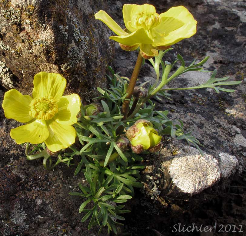
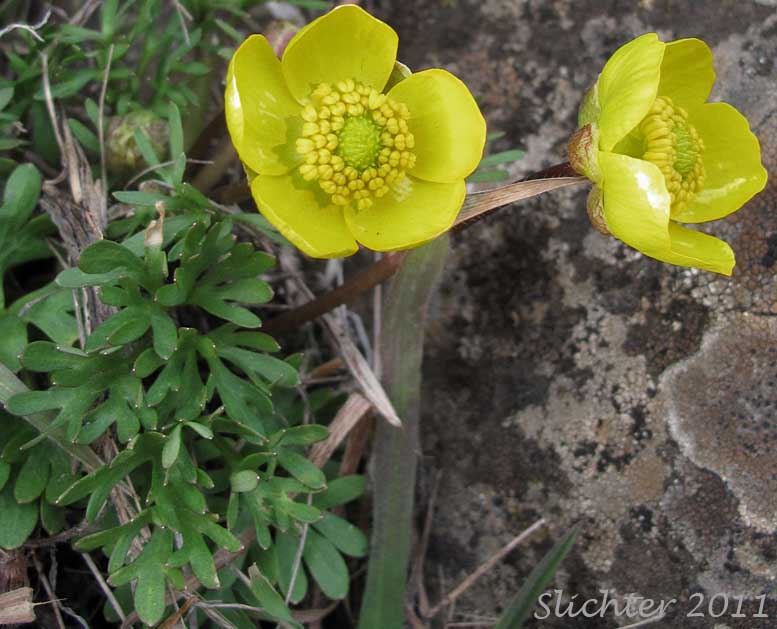
February 20, 2011: Wildflower bloom has started along the Klickitat River. A number of large patches of gold stars (Crocidium multicaule) were observed in bloom at various locations with sun exposure. A fair amount of pungent desert parsleys (Lomatium grayii) were also observed. Several obscure buttercups (Ranunculus triternatus), sagebrush buttercups (Ranunculus glaberrimus var. glaberrimus) and possibly the basalt buttercup (Ranunculus basalticus) but with wider, flat leaf segments) were observed. I also saw a number of desert shooting stars (Dodecatheon conjugens) with the inflorescence beginning to peak up between the basal leaves. They should begin blooming soon once the upcoming cold spell is finished. I only saw one immature bald eagle during the day, so most of them seem to have moved on to other food locations.
Along the Columbia River between Bingen and Lyle, about one-half of the pungent desert parsleys (Lomatium grayi) are now in bloom although plants are still very small. One nice-sized Columbia desert parsley (Lomatium columibanum) was observed in bloom on a rocky slope about 200 meters west of the rest area on SR14. It is possible that yellow bells (Fritillaria pudica) could soon be in bloom on sunny slopes east of Lyle.
February 12, 2011: Triple Falls Loop (Oneonta and Horsetail Falls Trails) A few western saxifrages (old Saxifraga occidentalis var. ?) were observed with flower buds on cliffs above the parking area to the west of Oneonta Gorge along the old highway. Several of the weedy Ranunuculus ficaria were observed next to the road about 100 meters east of the old highway tunnel located just east of Oneonta Gorge. I looked for mountain kittentails (Synthyris stellata) which can sometimes be seen blooming along the highway west of Multnomah Falls at this time of year, but did not see any. An early western swallowtail was observed flying along the Klickitat River on Sunday February 13!
February 9, 2011: Washington Highway 142. Pungent desert parsley (Lomatium grayi) was observed beginning to bloom in a seep just uphill from the Canyon Creek bridge where the highway climbs east from the Klickitat River towards Goldendale.
February 5, 2011: Bowman Creek Preserve, Columbia Land Trust (Western Gray Squirrel Monitoring)
February 5, 2011: There are an increasing number of species in bloom in the eastern Columbia River Gorge. Salt and pepper (Lomatium piperi) and grass widows (Olsynium douglasii) are increasingly common at lower elevations at Catherine Creek, Coyote Wall, and Horsethief Butte. There were a couple of Columbia desert parsley (Lomatium columbianum) blooming along the lower trail at Catherine Creek. A few pungent desert parsley (Lomatium grayi) were in bloom on the grassy slopes above Doug's Beach. The white alder (Alnus rhombifolia) are now beginning to bloom along the Klickitat River. The grass widow leaves are about 5-6 cm high in the mid-elevation slopes of the Columbia Hills but are probably a week away from blooming. Some scale pods (Idahoa scapigera) were observed blooming on the rocky slopes to the north of SR 14 at Horsethief Butte. A nice patch of about 50 Dalles Mountain buttercups (now known as the obscure buttercup: Ranunculus triternatus) were found in bloom near The Dalles (See photos below.). It's still cold at night so the big species like desert parsleys are still very small, or haven't emerged yet. Many sites have few or no plants blooming yet. Note: Clouting of car windows has been occurring at Catherine Creek and the Fisher Hill Bridge (Klickitat Trail) trailheads. Hide valuables in the trunk before you get to the trailhead, or just leave them at home. In addition. the Forest Service has begun closing some bike trails (which hikers also use) between the Coyote Wall and Catherine Creek, so your favorite route may now be closed. Please stay off these trails so they can revegetate!
 -
- 
January 26, 2011: Old Highway 30 near the Dalles Discovery Center, Horsethief Butte, Three Bench Loop & Upper Swale Canyon
January 22, 2011: Catherine Creek to Coyote Wall. Near 60 degree day. Increasing number of wildflowers seen (though still not common) from Catherine Creek to the Coyote Wall. Some filberts are blooming at river level in White Salmon, WA.
January 18, 2011: Near Troutdale, OR - Thousands of filberts with catkins fully in bloom near water courses or in ditches. Many red alder (Alnus rubra) nearly ready to bloom (the alders still haven't bloomed as of January 26).
January 15, 2011: East Bank Deschutes River Trails (to MP 3.5) - Hazy sun and warm early in the morning giving way to an increasingly steady drizzle after lunch. Numerous white alder (Alnus rhombifolia) catkins ready to bloom. About 50 salt and pepper (Lomatium piperi) blooming on large rocky areas next to the river at about MP 3.0. A wet but enjoyable day!