[2025] [2024] [2023] [2022] [2021] [2020] [2019] [2018] [2017] [2016] [2015] [2014] [2013] [2012] [2011] [2010][2009] [2008] [2007] [2006] [2005] [2004] [2003] [2002] [2001]
August 27, 2000 Mouth of the Deschutes River (west bank)
May 13, 2000 Catherine Creek
April 23, 2000 The bloom of balsamroot and lupine seems to be building to a peak on the lower and mid elevation slopes along the Dalles Mt. Road.
April 23, 2000 Blalock Canyon Road
April 23, 2000 Philippi Canyon
April 23, 2000 East bank of the John Day River at its mouth.
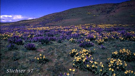
April 23, 2000 Higher elevation slopes (east bank) above the Deschutes River accessed via the Gordon Ridge Road.
April 16, 2000 Catherine Creek
April 9, 2000 South of Rufous, OR on Gerking Hollow Rd (0.5 miles above intersection with Scott Canyon Rd)
April 9, 2000 Mouth of the John Day River (West Bank)
April 2, 2000 Radio Tower at Crest of Gordon Ridge Road
April 2, 2000 North-facing slopes about 1/2-3/4 miles east of the east bank of the Deschutes River
March 23, 2000 Old Gorge Highway between Mosier, OR and Tom McCall Nature Preserve
March 23, 2000 Near The Dalles Dam Visitor's Center
March 23, 2000 Vicinity of Horsethief Butte State Park
March 23, 2000 Catherine Creek
March 23, 2000 Old Gorge Highway between Bridal Veil and McCord Creek
March 5, 2000 Catherine Creek
May 16, 1999 The Dalles Mt and the Columbia Hills
April 25, 1999 The Dalles Mt Rd
April 17, 1999 Wasco Butte & Chenoweth Rd
March 27, 1999 State Road 14 (Washington) east of US 97 & Rock Creek Rd.
March 7, 1999 Catherine Creek
February 21, 1999 Memaloose Viewpoint, near The Dalles, OR, The Dalles Mt., & Catherine Creek
July 4, 1998 Tom McCall Point Trail
July 4, 1998 Columbia Hills
May 9, 1998 Columbia Hills
April 19, 1998 Random spots along SR-14: Intersection of SR-14 and The Dalles Mt. Rd., Avery Boat Ramp,
April 18, 1998 Hood River Mt. Meadows
April 4, 1998 Tom McCall Nature Preserve, Catherine
March 14, 1998 Three Benchs Loop
March 8, 1998 Catherine Creek
March 1, 1998 Hood River Mountain Meadows, Memaloose, Twin Tunnels and the Columbia Gorge Scenic Highway between Bridal Veil and Ainsworth S.P..
February 15, 1998 Memaloose, Rowena, Chenoweth, The Dalles Mt, & Catherine Creek
September 14, 1997 Mouth of the Deschutes River (East Bank)
Early September 1997 General Wildflower Report for the Eastern Columbia River Gorge
June 1, 1997 The Dalles Mt Road, and the Columbia Hills to the northeast of Dallesport, WA.
May 10, 1997 Hillside (just east of Haystack Butte) between Washington State Road #14 and Goldendale, WA.
April 27, 1997 Catherine Creek
April 5, 1997 Memaloose Overlook on the Old Columbia River Highway
March 2, 1997 Governor Tom McCall Nature Preserve & Rowena Overlook