 The
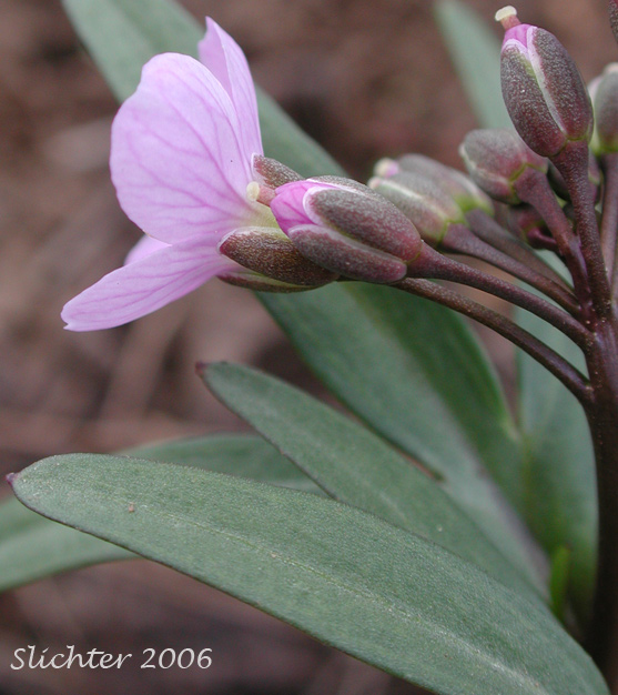
photo at right shows the flower of oaks toothwort Cardamine nuttallii var.
nuttallii as seen on Mt. Adams........May 6, 2006.
The
photo at right shows the flower of oaks toothwort Cardamine nuttallii var.
nuttallii as seen on Mt. Adams........May 6, 2006.
The following links are all for Mt. Adams in the southern Washington Cascades:
October 13, 2006: Bird Creek Meadows (accessed via the Cold Springs Trailhead & the Round the Mountain Trail #9) and the climbers trail along the crest of the ridge to the south of Hell Roaring Meadows.
September 30, 2006: King Mt. - Road S1750
September 30, 2006: Conboy National Wildlife Refuge - Willard Springs Trail
September 30, 2006: Conboy National Wildlife Refuge - Kreps Lane
September 10, 2006 - I spent the day wandering along the western slopes of the Indian Heaven Wilderness. Some of the vine maples and huckleberry bushes are beginning to turn to orange and red shades of color. I spent much of the midday picking huckleberries, 3 types (red, purple and blue) but all but the blue huckleberries are largely well past their prime. The forest is still very dry, with little rainfall this summer. Even the weeds have largely dried up. Care should be taken when walking through brush or areas of low visibility as numerous hunters are out and about at the commencement of bow hunting season.
September 10, 2006: Mt. Adams Viewpoint on Road #23
August 13, 2006: Bird Creek Meadows (from the parking lot to the Mt. Adams Wilderness boundary)
August 13, 2006: Bench Lake
August 12, 2006: The Ridge of Wonders
August 12, 2006: Island Springs Trail #66
July 28, 2006: Willard Springs Trail, Conboy Lake National Wildlife Refuge
July 27, 2006: Horseshoe Meadows & slopes above it to 7000'
July 27, 2006: Stagman Ridge Trail #12
July 27, 2006: Stagman Ridge Trail #12 Trailhead
July 17, 2006: Island Springs Trail #66
July17, 2006: Bench Lake
July 16, 2006: Bird Creek Meadows
July 16, 2006: Crofton Ridge Trail #73
July 9, 2006: Road S1750 above 4000' on the eastern slopes of King Mt.
July 9, 2006: Road K1000 near the Yakima-Klickitat County Line
July 9, 2006: Island Cabin Campground
July 9, 2006: Kreps Lane (Conboy Lake National Wildlife Refuge)
July 9, 2006: Laurel Road (Conboy Lake National Wildlife Refuge)
July 2, 2006: Road K1000 near the Yakima-Klickitat County Line
July 2, 2006: Conboy Lake National Wildlife Refuge - Kreps Lane & Laurel Road
June 19, 2006: Island Cabin Campground
June 19, 2006: Dry Creek Drainage above 4000'
June 18, 2006: DNR Rock Quarry along well gravelled road veering north of K6000 on Rd K6900. Quarry is at summit of ridge between Dairy and Cougar Creeks, at about 4100'. ------- N46 07.861' --- W121 20.216' --- Elevation: 4123' --- +/-16'
June 18, 2006: Rocky meadow on north side of Road K6000 at N46 06.241' --- W121 19.137' --- Elevation: 2780' --- +/-22'
June 18, 2006: Road K1000 to the east of the Mt. Adams Highway, roughly paralleling the Yakima & Klicktat Counties boundary.
June 18, 2006: Conboy Lake National Wildlife Refuge - Kreps Lane & Laurel Road
May 30, 2006: Conboy Lake National Wildlife Refuge - Willard Springs Trail. At about 1800' at the southeastern foot of Mt. Adams.
May 30, 2006: Island Cabin Campground
May 30, 2006: Dry Creek Drainage above 3000' (along Road K4000)
May 29, 2006: DNR Rock Quarry along well gravelled road veering north of K6000 on Rd K6900. Quarry is at summit of ridge between Dairy and Cougar Creeks, at about 4100'. ------- N46 07.861' --- W121 20.216' --- Elevation: 4123' --- +/-16'
May 29, 2006: Rocky meadow on north side of Road K6000 at N46 06.241' --- W121 19.137' --- Elevation: 2780' --- +/-22'
May 29, 2006: Road K1000 east of the Mt. Adams Highway, roughly paralleling the Yakima & Klicktat Counties boundary.
May 29, 2006: Road descending into Klickitat Canyon to the Klickitat Fish Hatchery
General Report for SE Mt. Adams, May 19, 2006: The snow level is now higher than the previous report, but most roads on the southeastern flanks of Mt. Adams are still closed by snow drifts between 3700'-4000', unless they give access to rock pits or logging sites that are being accessed. The lower elevations seem to be experiencing a sooner bloom than last year (which was early), but this might be because of the moister soils this year and the recent spate of 80 degree weather. Several rain showers on Friday the 19th provided up to 0.4 inches of additional precipitation.
May 19, 2006: Open forest between Roads K2000 and K3000.
May 19, 2006: Road K1000 east of the Mt. Adams Highway, roughly paralleling the Yakima & Klicktat Counties boundary.
May 19, 2006: Rocky meadow on north side of road at N46 06.241' --- W121 19.137' --- Elevation: 2780' --- +/-22'
May 19, 2006: DNR Rock Quarry along well gravelled road veering north of K6000 on Rd K6900. Quarry is at summit of ridge between Dairy and Cougar Creeks, at about 4100'. ------- N46 07.861' --- W121 20.216' --- Elevation: 4123' --- +/-16'
May 19, 2006: Island Cabin Campground (WA DNR CG on Bird Cr)
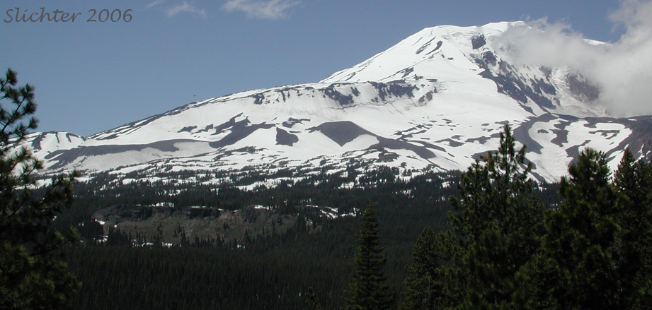
General Report for SE Mt. Adams, May 6, 2006: It is now spring on Mt. Adams and the snow is melting fast. I viewed the mountain from over 30 miles away in late April (from the Columbia Hills) and there appeared to be quite a bit of snow down to near 2000' at that point. As of May 6, much of the lower snow has melted and one starts encountering small patches of snow at about 2400', but many roads have been plowed up to and above 4000'. Although open, many of the roads are very rough with large sized gravel which is hazardous as I discovered to the tires of passenger cars. Above 3000', many open slopes with south-facing slopes have become snow free, with some wildflower bloom of small, early blooming species. The north-facing slopes still have 1-2 feet of snow and more where there were drifts. The only report on snow depth I've seen so far from the Gifford Pinchot NF is that the snow depth is higher than the outhouses at Cold Springs CG and that they were optimistic that they would be able to open the road to that important trailhead for the South Climb Trail by the 1st of July. We'll have to see whether the snow clears out early enough for the Yakamas to open Road 82 to the Bird Creek Meadows Trailhead by that time.
May 6, 2006: Unamed road connecting the Glenwood-Goldendale Highway to the Mt. Adams Highway, roughly paralleling the Yakima & Klicktat Counties boundary.
May 6, 2006: Rd K6900 - DNR Rock Quarry along well gravelled road veering north of K6000 on Rd K6900. Quarry is at summit of ridge between Dairy and Cougar Creeks, at about 4100'. ------- N46 07.861' --- W121 20.216' --- Elevation: 4123' --- +/-16'
May 6, 2006: Rd K6000 to the west of the Road K1000 - Rocky meadow on north side of road at N46¾ 06.241' --- W121¾ 19.137' --- Elevation: 2780' --- +/-22'
May 6, 2006: Rd K3000 from Glenwood, WA to Bird Creek Camp -
May 6, 2006: Mt. Adams Highway & Road K1000


