[The Flora of Mt. Adams Country] [Wildflower Bloom in the Cascade Mts. of Southern Washington: [2023] [2022] [2021] [2020] [2019] [2018] [2016] [2015] [2014] [2013] [2012] [2011] [2010] [2009] [2008] [2007] [2006] [2005] [Prior to 2005]
The following links all are for Mt. Adams in the southern Washington Cascades:
November 9, 2005: Views of Mt. Adams with a new coat of snow as seen from Glenwood, WA and Trout Lake, WA.
October 22, 2005: Several views of Mt. Adams from the Round the Trail #9.
October 22, 2005: Various sites along K6000 and K6900 on the southeastern slopes of Mt. Adams
October 22, 2005: View of Mt. Adams from near the Conboy National Wildlife Refuge, Conboy, WA
October 14, 2005: Rd #2360 (Includes views of the fall foliage near Sleeping Beauty)
October 14, 2005: Rd #23 at the Mt. Adams Viewpoint (1/2 mile south of Rd #8810)
October 14, 2005: Rd #150 at the Snipes Mt. Trailhead
October 14, 2005: Rd #82 at Snow King Snopark
September 25, 2005: Pacific Crest Trail from Riley Trail #64 to Crystal Lake
September 25, 2005: Riley Trail #64 (from Rd #23 to the Pacific Crest Trail)
September 25, 2005: Rd #23 at the Mt. Adams Viewpoint (1/2 mile south of Rd #8810)
August 26, 2006: Rd #23 at the Mt. Adams Viewpoint (1/2 mile south of Rd #8810)
August 25, 2005: Island Springs Trail #66
August 25, 2005: Rd #82 at Snowking Snopark
August 6, 2005: Road #2329 (TakhTakh Meadows Trail and Muddy Meadows)
August 6, 2005: Road #23 from the Mt. Adams Viewpoint (1/2 mile south of Rd #8810) and Swampy Meadows (opposite the junction of Rds #23 and #521)
July 31, 2005: Rd K6900 - DNR Rock Quarry along well gravelled road veering north of K6000 on Rd K6900. Quarry is at summit of ridge between Dairy and Cougar Creeks, at about 4100'. ------- N46 07.861' --- W121 20.216' --- Elevation: 4123' --- +/-16' . Also inlcludes plants along K6000 at about 2800'.
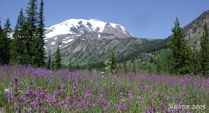
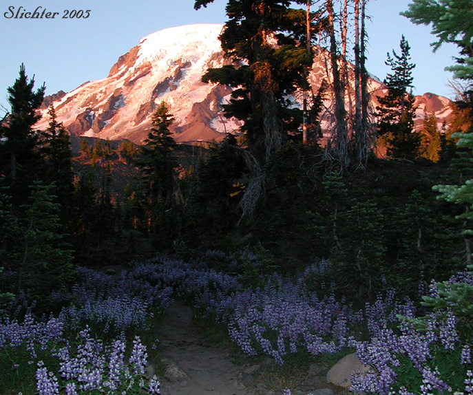
July 30, 2005: Bird Creek Meadows Picnic Area Loop up to Hellroaring Overlook
July 29, 2005: Shorthorn Trail & Round the Mountain Trail #9 (from Morrison Creek Camp to Madcat Meadows)
July 24, 2005: Red Butte
July 24, 2005: Devils Garden
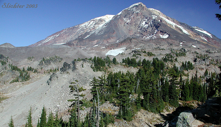
July 23, 2005: North Side of Mt. Adams above the Highline Trail #114 below Lava Glacier
July 17, 2005: Meadows along Hellroaring Creek at Island Springs Trail
July 16, 2005: Island Springs Trail #66
July 12, 2005: Potato Hill - Access via Pacific Crest Trail from trailhead on Forest Rd. 5603
July 11, 2005: Highline Trail #114 from Muddy Meadows Trail #13 to ~7460' (below the Devils Garden)
July 10, 2005: Rd K6000 - Small spur road running north about 1/4 mile from the uppermost end of Rd K6000. A small trail runs north through clearcuts to boggy seeps that flow eventually to Cougar Creek? ------- Trailhead: N46 07.945' --- W121 21.861' --- Elevation: 4425' --- +/-20' -------- Meadows:--- N46 08.150' --- W121 21.732' --- Elevation: 4435' --- +/-20'
July 10, 2005: Rd K6900 - DNR Rock Quarry along well gravelled road veering north of K6000 on Rd K6900. Quarry is at summit of ridge between Dairy and Cougar Creeks, at about 4100'. ------- N46 07.861' --- W121 20.216' --- Elevation: 4123' --- +/-16'
July 10, 2005: Rd K6000 to the west of the Mt. Adams Highway - Rocky meadow on north side of road at N46 06.241' --- W121 19.137' --- Elevation: 2780' --- +/-22'
July 1, 2005: Yakama Reservation: Hellroaring Creek Trail #10
July 1, 2005: Yakama Reservation: Island Springs Trail #66
June 21, 2005: Muddy Meadows
June 21, 2005: Potato Hill
June 19, 2005: Rd K6000 - Small spur road running north about 1/4 mile from the uppermost end of Rd K6000. A small trail runs north through clearcuts to boggy seeps that flow eventually to Cougar Creek? ------- Trailhead: N46 07.945' --- W121 21.861' --- Elevation: 4425' --- +/-20' -------- Meadows:--- N46 08.150' --- W121 21.732' --- Elevation: 4435' --- +/-20'
June 19, 2005: Crofton Butte - Crofton Ridge Trail to Crofton Creek and up to the ridgetop (via the trail), then cross country to the open slopes below the top of Crofton Butte.
June 11, 2005: Rd K6900 - DNR Rock Quarry along well gravelled road veering north of K6000 on Rd K6900. Quarry is at summit of ridge between Dairy and Cougar Creeks, at about 4100'. ------- N46 07.861' --- W121 20.216' --- Elevation: 4123' --- +/-16'
May 29, 2005: Rd K6900 - DNR Rock Quarry along well gravelled road veering north of K6000 on Rd K6900. Quarry is at summit of ridge between Dairy and Cougar Creeks, at about 4100'. ------- N46 07.861' --- W121 20.216' --- Elevation: 4123' --- +/-16'
May 29, 2005: Rd K6000- Small spur road running north about 1/4 mile from the uppermost end of Rd K6000. A small trail runs north through clearcuts to boggy seeps that flow eventually to Cougar Creek? ------- Trailhead: N46 07.945' --- W121 21.861' --- Elevation: 4425' --- +/-20' -------- Meadows:--- N46 08.150' --- W121 21.732' --- Elevation: 4435' --- +/-20'
May 28, 2005: Snipes Mt. -
May 28, 2005: SnoKing SnoPark - N46 03.231' --- W121 28.344' --- Elevation: 3230' --- +/- 28'
May 28, 2005: Crofton Butte and Crofton Ridge Trail #73 - Accessed via Morrison Creek CG
May 22, 2005: Rd K6900 - DNR Rock Quarry along well gravelled road veering north of K6000 on Rd K6900. Quarry is at summit of ridge between Dairy and Cougar Creeks, at about 4100'. ------- N46 07.861' --- W121 20.216' --- Elevation: 4123' --- +/-16'
May 22, 2005: Rd K6000- Small spur road running north about 1/4 mile from the uppermost end of Rd K6000. A small trail runs north through clearcuts to boggy seeps that flow eventually to Cougar Creek? ------- Trailhead: N46 07.945' --- W121 21.861' --- Elevation: 4425' --- +/-20' -------- Meadows:--- N46 08.150' --- W121 21.732' --- Elevation: 4435' --- +/-20'
May 22, 2005: Rd K6000 above Hellroaring Ditch - steeply descending slopes on north side of road at upper end of clear cut. ------- N46 07.445' --- W121 20.599' --- Elevation: 3959' --- +/-20'
May 22, 2005: Rd K6000 to the west of the Mt. Adams Highway - Rocky meadow on north side of road at N46 06.241' --- W121 19.137' --- Elevation: 2780' --- +/-22'
May 14, 2005: Rd K6600 above the Hellroaring Ditch & Clear cut at end of spur road above end of Rd K6600
May 14, 2005: Rd K6000 to the west of the Mt. Adams Highway - Rocky meadow on north side of road at N46 06.241' --- W121 19.137' --- Elevation: 2780' --- +/-22'
May 7, 2005: Rd K6000 to the west of the Mt. Adams Highway - Hellroaring Ditch and points above.
May 7, 2005: Rd K6000 to the west of the Mt. Adams Highway - Rocky meadow on north side of road at N46 06.241' --- W121 19.137' --- Elevation: 2780' --- +/-22'
May 7, 2005: Rd K3000 from GPNF Rd 82 to Glenwood, WA - Plants not seen at points on the lists below.
May 7, 2005: Gifford Pinchot NF Rds 071 & 150 to Snipes Mt. (including Trailhead for Snipes Mt. Tr #11)
May 7, 2005: Gifford Pinchot NF Rd 82 (Trout Lake to Bird Cr Meadows) - Various stops from clearcut (below) to boundary of Tract D Yakama Nation (2500-4000').
May 7, 2005: Gifford Pinchot NF Rd 82 (Trout Lake to Bird Cr Meadows) - Clearcut at N46 02.346' --- W121 30.404' --- Elevation: 2542' --- +/-14'
May 1, 2005: Mt. Adams Highway