Wildflower Viewing Areas in the Columbia
River Gorge of Oregon and Washington
The Columbia Hills Historical State Park and the Columbia Hills Natural Area Preserve
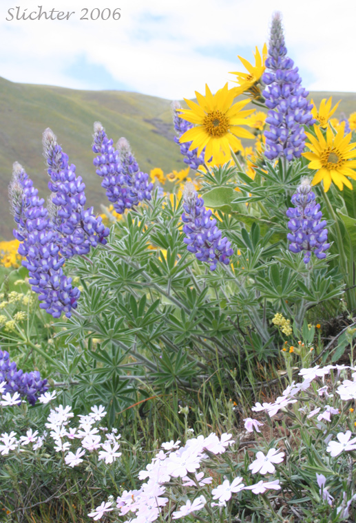
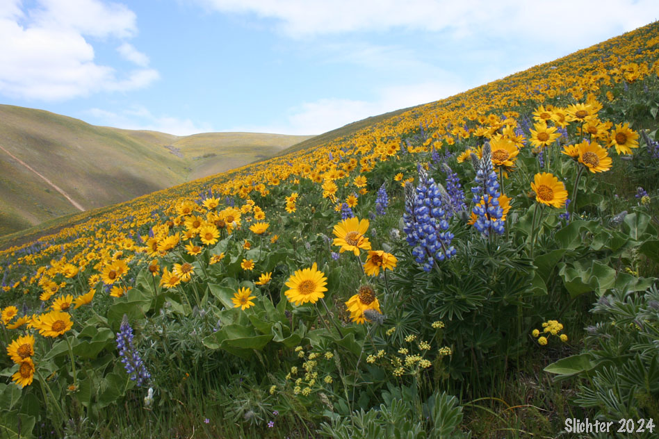
Columbia Gorge Lupine, Showy Phlox, and Northwestern Balsamroot in bloom along the Dalles Mt. Road.........mid-April 2006.
There are 4 trailheads at the Columbia Hills State Park. Two are along Washington Highway 14, the Crawford Oaks and Horsethief Butte Trailheads. The following are explained on this page: Dalles Mt. Ranch and the upper trailhead for the Columbia Hills Historical State Park/Columbia Hiills Natural Area Preserve..
Discover Pass Required: All 4 trailheads as well as Washington Highway 14 shoulders adjacent to Crawford Oaks and Horsethief Butte as well as any portion of The Dalles Mt. Road passing through Columbia Hills State Park. Display the pass with appropriate license plate info to avoid the $99 fine. All roads and trailheads are patrolled multiple times a day!
Daily passes are available from kiosks with iron rangers at the Horsethief Butte, Crawford Oaks and Dalles Mt. Ranch trailheads. Yearly passes are available at the state park headquarters at Horsethief Lake (usually reliably staffed from April on), online from the Washington State Parks website, at hardware and recreational stores throughout Washington, and from REI in Portland.
Note: Dogs and bikes are not allowed in the Columbia Hills Natural Area Preserve. Hiking off of the main road to Stacker Butte is not permitted to protect nesting birds, rare plants and sensitive habitats. DNR workers frequently work up in the preserve and will be looking for offenders. Dogs must be on leash at all times within the Columbia Hills Historical State Park. Rangers do walk the trails on occasion and ticket offenders.
Eastbound:
From Bingen, WA, take State Road 14 east, crossing the Klickitat River at Lyle, WA and eventually passing US
197 on the right which crosses the Columbia River to The Dalles, OR. (another access point from the west, the bridge here is free). Proceed
about another half mile and at about milepost 84.5 turn left (north) onto the
graveled Dalles Mt. Road.
Westbound:
From the intersection of US 97 and State Road 14 on the Washington
side of the Columbia, proceed west. Eventually you will pass Columbia Hills
State Park (with Horsethief Butte and Horsethief Lake) on the left (river side of the road) at about milepost 85.1. Clean, flush restrooms, water, picnic and camping facilities are found at this location. Proceed
west on the main highway about another one-half mile and then turn right at about
milepost 84.5 onto The Dalles Mt. Road.
This intersection may provide a nice chance to see such April
and May blooming flowers as Hood River Milk Vetch and Panicled Death-camas and
Bicolored Cluster Lily. Do not take the paved first left after leaving the highway.
This is a private road.
Proceed straight up the gravel road which will at first
wind slightly to the right (east), passing clusters of perfumed mock orange and choke
cherry (when in bloom in May). When the road begins to climb steeply, one may catch sweeping views
of grassland, and prolific clusters of lupine and balsamroot. At this point,
one can find perhaps 5 types of lupine and as many species of desert parsley.
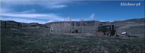
The Dalles Mt Ranch, where you can park and hike up to the crest
of the Columbia Hills in the background. Currently, quite a few pieces of "old-fashioned" farm equipment are situated behind the wagon for viewing.
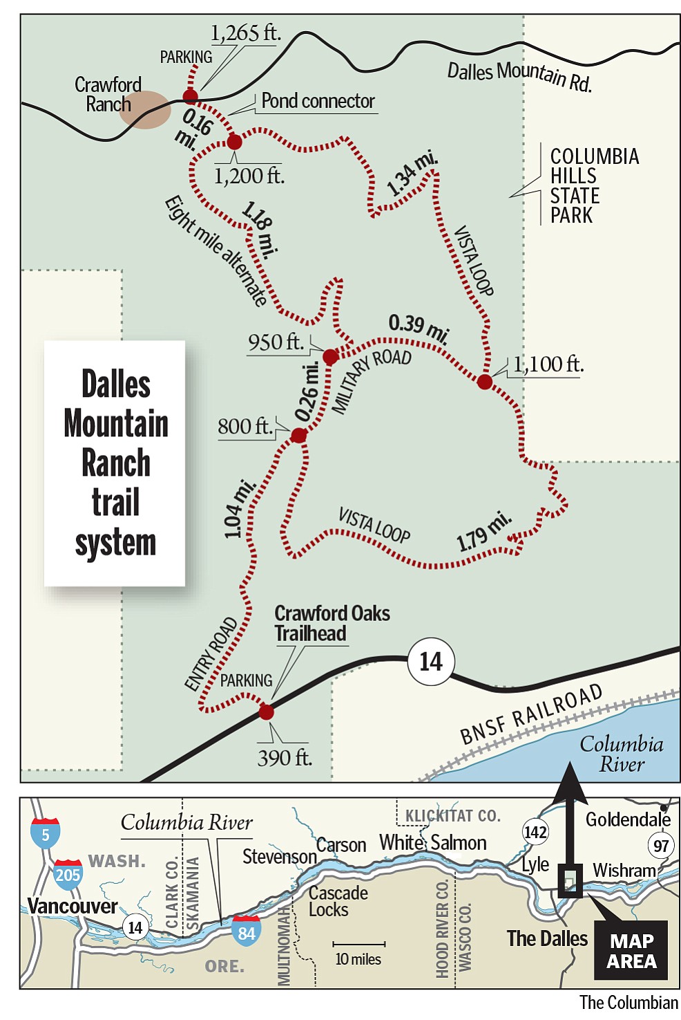 Dalles Mt. Ranch Trailhead: Eventually you will reach the Dalles Mt Ranch which is an old
ranch straddling the road. One can proceed straight on this road to reach the
Dalles Mt. itself, or one can park at the signed trailhead just east of the large ranch barn at the left.
This is the entrance to the park. If parking along The Dalles Mt. Road, be careful not to block any of the roads when
you park and display that Discover Pass! Dogs should be on leash to protect deer and other mammalian wildlife as well as ground-nesting birds! Rattlesnakes are present under the oaks and brush along the branches of Eightmile Creek and on rock outcrops above the Crawford Oaks trailhead.
Dalles Mt. Ranch Trailhead: Eventually you will reach the Dalles Mt Ranch which is an old
ranch straddling the road. One can proceed straight on this road to reach the
Dalles Mt. itself, or one can park at the signed trailhead just east of the large ranch barn at the left.
This is the entrance to the park. If parking along The Dalles Mt. Road, be careful not to block any of the roads when
you park and display that Discover Pass! Dogs should be on leash to protect deer and other mammalian wildlife as well as ground-nesting birds! Rattlesnakes are present under the oaks and brush along the branches of Eightmile Creek and on rock outcrops above the Crawford Oaks trailhead.
You can hike uphill cross country to the upper parking area for the Columbia Hills NAP (pretty weedy and rough). Follow the signed trail south from the parking area, cross the Dalles Mt. Road and then trails take you several miles on west or eastern loops. Take plenty of water and a coat as
the landscape is exposed to wind and the heat of the sun.
To Access the trailhead for the Columbia Hills NAP: A gravel road (sometimes pretty rough) asends steeply uphill just west of the farm equipment on display at the Dalles Mt. Ranch. You will pass a house about
one-half mile up. Don't stop here, but continue into the wide open grasslands,
eventually climbing via several broad switchbacks via the road to a parking area with several interpretive signs. Beyond the gate and uphill of the fence is the Columbia Hills Natural Area Preserve. This should give a much shorter walk of about 2 miles to the summit of the ridge. Again, be sure not to block the
gate! Please also respect any private property/no trespassing signs!
* Note: Stay on the roads within the Columbia Hills NAP. The natural area is technically a restricted area so while it is ok to hike cross country through the state park, the upper half of the Columbia Hills is off limits to cross country travel! Horses, dogs and mountain bike traffic are not allowed anywhere within the Natural Area Preserve (all of the upper half of the ridge)! Hiking groups need to obtain a permit from the Washington Department of Natural Resources office in Ellensburg prior to the trip. See the sign below which is posted at the upper parking lot for more info.
The ridge top affords a beautiful 360 degree view of Mt. St
Helens, Mt. Adams, Mt. Hood, and the forested and agricultural lands in between.
The flora at the ridgetop is protected, so pleasedon't wander off the road
up here so these fragile plants won't be trampled. Basically, all the plants you would see are observable along the road. Be alert for rattlesnakes
and ticks.
Continuing east along the Dalles Mt. Road:
One may also proceed via auto on the Dalles Mt. Road to the
the radio tower at the summit of The Dalles Mt. The road up affords beautiful
views to the south of the Columbia River and the farmlands atop the plateau
south of the river in Oregon. The road here is narrow, and sometimes in a state
of disrepair (it can also be very slick when muddy). Also watch the road ahead
for approaching vehicles. Some people drive very fast here, while others tend
to watch only the views and vast expanse of flowers. The summit (at the radio
tower) is approximately 8 miles from State Road 14. It is at about 2,200 feet
in elevation. The unfenced section here is Indian lands but hiking is allowed here. East of the state park (the fences will be periodically signed), be careful not to cross fences into private property. The habitat here is a mixture of grasslands, and rocky/graveled
scablands. Many beautiful but small plants may be found here, including several
kinds of phlox, grass widows, yellow bells, desert parsleys, and of course several
lupines and the beautiful Arrowleaf Balsamroot. Take care when walking not to
step on these fragile plants!
One can proceed northeast on the Dalles Mt. Road, eventually
descending towards Goldendale, WA, or turning east to proceed towards the north
entrance to Haystack Butte, another magnificent wildflower site.
 -
- 
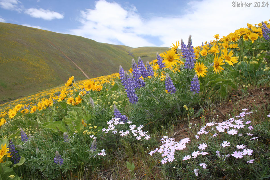
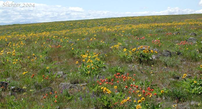
Columbia Gorge lupine, showy phlox, barestem desert parsley and Carey's balsamroots in bloom on slopes within the Columbia Hills Historical State Park.....April 24, 2006.
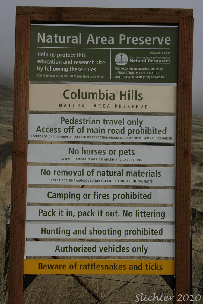 The photo at right shows a sign mounted at the upper parking lot at the boundary between the Columbia Hills State Park and Columbia Hills Natural Area. There are more restrictions for entering the NAP when compared with regulations governing the lower state park.
Plant Lists:
Comprehensive Plant List for Columbia Hills (pdf)
May 2, 2018: Trails between the Dalles Mt. Ranch and Crawford Oaks trailheads, Columbia Hills Historical State Park.
March 24, 2017: Columbia Hills Natural Area Preserve
March 25, 2016: Stacker Butte Road, Columbia Hills NAP
March 3,2016: Columbia Hills State Park and Columbia Hills Natural Area Preserve
April 16, 2015: Upper Columbia Hills State Park and Columbia Hills Natural Area Preserve. - Remember to display your Washington Discover Pass to avoid the $99 fine!
March 5, 2015: Columbia Hills Natural Area Preserve
February 15, 2015: Columbia Hills State Park (above the Dalles Mt. Ranch trailhead and below the Columbia Hills NAP)
April 12, 2014: Columbia Hills State Park & Natural Area Preserve
March 24, 2014: Columbia Hills State Park from the Dalles Mt. Ranch to just below the Columbia Hills NAP
March 12, 15 & 19, 2014: Columbia Hills Natural Area Preserve & Columbia Hills State Park
April 3, 2013: Columbia Hills State Park and Columbia Hills Natural Area Preserve
March 19 & 20, 2013: Columbia Hills NAP
March 27, 2012: Columbia Hills NAP
March 7, 2012: Columbia Hills State Park (between the Dalles Mt. Ranch trailhead and the Columbia Hills NAP)
February 15, 2010: Columbia Hills State Park and Columbia Hills NAP
May 17, 2009: Columbia Hills Natural Area Preserve (A Joint Native Plant Society of Oregon and Friends of the Columbia Gorge Hike.)
April 19, 2009: Columbia Hills Natural Area Preserve (A North American Rock Garden Society hike)
March 16, 2009: The Dalles Mountain Road (A North American Rock Garden Society hike)
June 14, 2008: Columbia Hills Natural Area Preserve - Native Plant Society of Oregon Hike
April 20, 2008: Columbia Hills Natural Area Preserve - Friends of the Columbia Gorge Hike
April 11, 2008: Columbia Hills Natural Area Preserve
April 7, 2007: Columbia Hills Natural Area Preserve
March 17, 2007: Columbia Hills Natural Area Preserve -
March 17, 2007: Access Road to the Parking Area at the Base of the Columbia Hills Natural Area Preserve
March 17, 2007: The Dalles Mt. Road
July 7, 2006: Columbia Hills Natural Area Preserve
June 3, 2006: Columbia Hills Natural Area Preserve
June 3, 2006: The Dalles Mt. Road
May 14, 2006: Columbia Hills Natural Area Preserve
April 24, 2006: The Dalles Mt. Road
April 9, 2006: The Dalles Mt. Road (from SR-14 to the high point on the Dalles Mt. Rd)
May 1, 2005
April 9, 2005
February 26, 2005
May 30, 2004
May 9, 2004
March 27, 2004
March 27, 2004
May 3, 2003
May 18, 2002
March 22, 2002
April 22, 2001
March 10, 2001
May 16, 1999
July 4, 1998
May 9, 1998
February 15, 1998
June 1, 1997
Online Resources:
Columbia Hills Natural Area Preserve - Washington Department of Natural Resources
Columbia Hills Historical State Park - Washington State Parks
Stacker Butte Trailhead - OregonHikers.org
Stacker Butte Hike - OregonHikers.org
Dalles Mountain Ranch Loop Hike - OregonHikers.org
Columbia Hills Natural Area Preserve: Stacker Butte - Washington Trails Association (This webpage mistakenly states that Stacker Butte is part of the Columbia Hills Historical State Park.)
Columbia Hills Natural Area Preserve: Stacker Butte - Friends of the Columbia Gorge (Likewise, this webpage mistakenly states that this area is part of the Columbia Hills Historical State Park.)
Wildflower bloom atop the Columbia Hills near Stacker Butte.
Paul Slichter