Malheur National Forest
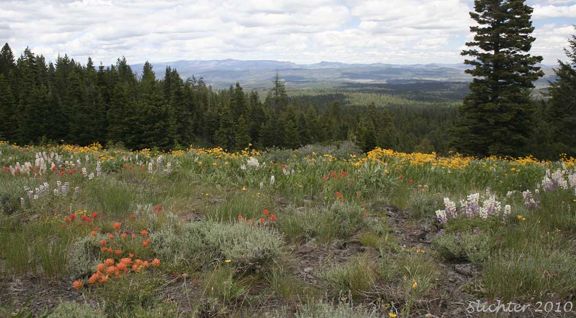
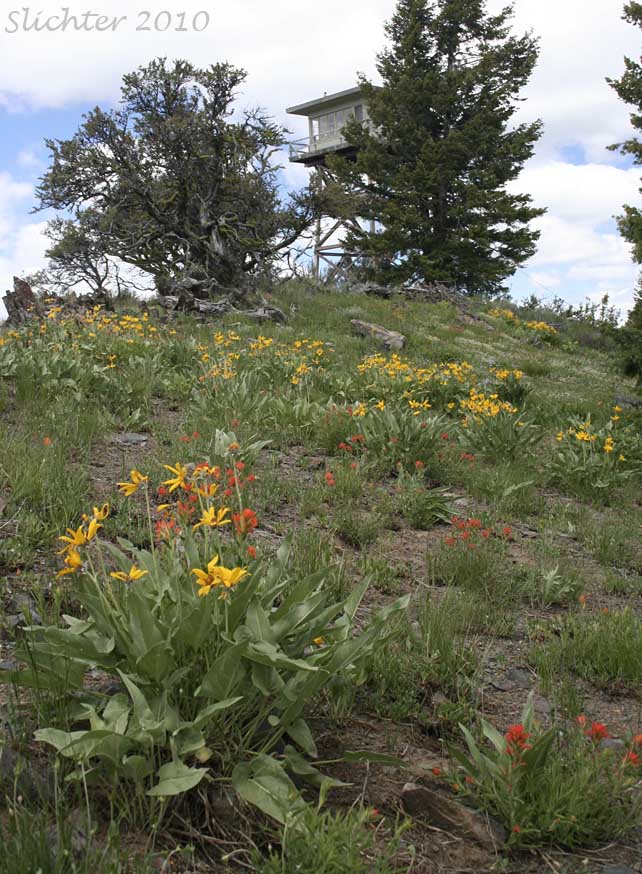
Antelope Mt. (6454') is located in the southeastern Malheur National Forest on the Grant County/Harney County Line. The mountain itself is a rocky bald with wildflower meadows on it summit as well as on the southern and western exposure. Coniferous forests of ponderosa pine, douglas fir and sierra white fir are found on the northern and eastern slopes. The crest of the mountain affords a near 360 degree view of the surrounding country, with views to the Aldrich and Strawberry Mountains in the north, the Monument Rock Wilderness to the northeast, and a distant view of Steens Mountain to the south. One can also see southwards towards the central Malheur River drainage near Van, OR and to a lesser extent, some of the country to the southeast around the Little Malheur River. The lookout is manned during the fire season when visitors can ask for permission to ascend for a fuller view. The floriferous ridgeline can be hiked north and south from the summit parking area and the open slopes to the west as well as the forest to the east offer excellent off trail exploration. There are some nice rock gardens located on the southeast side of the crest about 2-300 meters south of the lookout.
The actual access road to the summit from FS Rd 14 is steep and rough but passable for most passenger vehicles. Hybrids and those which are especially low to the ground will have difficulty. Vehicles with higher clearance like Subarus and SUVs should have no problem except early in the spring when the lower road might be muddy and the upper portions covered with snow patches. The road up is narrow with no place to turn around until the summit is reached. There is only room for a handful of vehicles to park at the summit.
This is probably suitable as a destination for a half day visit. It can be combined with floral explorations along the other access roads listed below or with stops in Logan Valley.
From Prairie City, OR: Drive south on paved Grant County Road 62 for about 40-45 minutes until reaching Summit Prairie. Continue straight on what becomes FS Rd 16 (Turning sharply right onto FS Rd 16 takesyou west towards Logan Valley and Seneca, OR.). Continue south for a little over 2 miles before veering right onto the gravel FS Rd 14 for about 15 minutes until reaching a 5-way junction with FS Rd 1663 and spur road 534. Either drive up spur road 534 or park at the fence line and hike upslope to the summit of Antelope Mt via the road, or cross country through the mostly open forest.
From John Day, OR: Drive south on US Highway 395. Turn southeast onto Grant County Rd 65 which becomes FS Rd 15 at the forest boundary. Turn east onto FS Rd 16, passing through Logan Valley and eventually reaching Summit Prairie where you will turn south, staying on FS Rd 16. The rest of the route follows the instructions for access from Prairie City.
Alternate Routes from Logan Valley: From the east end of Logan Valley (about one mile east of Big Creek Campground, turn south onto gravel FS Rd 1647. Drive south through a mix of upland meadow, upland sagebrush/shrub, and coniferous forest keeping in mind that private lands are to the west of the road while forest service lands are usually (although not always) east of the road. There are several nice campsites at the scenic meadows at Summit Creek. At Summit Creek, turn left (east) and drive uphill on FS Rd 1450, skirting the edge of Larch Creek (which has some nice riparian areas to explore) for a number of miles. At the crest of the ridge, one can turn left (east) onto FS spur road 185 and proceed east to FS Rd 14, which can then be followed south to the base of Antelope Mt. Or one can continue straight on FS Rd 1450 along the ridgetop, passing through mostly open forest. Be observant for cattle, mule deer and elk on the road. Just past spur road 391 (which is on the right), turn left onto spur road 941, driving east downhill to FS Rd 14. Again, turn right (south) onto FS Rd 14 and drive about 2 more miles to the base of Antelope Mt.
From Seneca, OR: From US Highway 395 at Seneca, drive east on FS Rd 16, eventually arriving at Logan Valley after 16 miles. Continue east on FS Rd 16 to Summit Prairie where you will turn south, staying on FS Rd 16. The rest of the route follows the instructions for access from Prairie City. The alternate routes from Logan Valley can be followed from the John Day directions.
The peak of the bloom season should be from mid June to mid July most years. Floral highlights in the spring include: arrowleaf balsamroot (Balsamorhiza sagittata), bitterroot (Lewisia rediviva), Cusick's elkweed (Frasera columbiana var. cusickii), daggerpod (Phoenicaulis cheiranthoides), foothills daisy (Erigeron corymbosa), narrowleaf mock goldenweed (Nestotus stenophyllus), nettle-leaf horsemint (Agastache urticifolia), Rocky Mt. sunflower (Helianthella uniflora var. douglasii), scabland fleabane (Erigeron bloomeri var. bloomeri), scarlet gilia (Ipomopsis aggregata), spurred lupine (Lupinus arbustus), wavy-leaf paintbrush (Castilleja applegatei var. pinetorum) plus yellow desert daisy (Erigeorn linearis). In addition there are several species of hawksbeards as well as 5 or more species of buckwheats including parsnipflower buckwheat (Eriogonum heracleoides var. heracleoides), strict buckhwheat (Eriogonum stricum var. proliferum) and sulfur flower buckwheat (Eriogonum umbellatum).
During the late summer/early fall, expect to find low sagebrush (Artemisia arbuscula ssp. arbuscula), mountain big sagebrush (Artemisia tridentata ssp vaseyana) and showy rubber rabbitbrush (Ericameria nauseosa var. speciosa) in bloom.
Expect to see mule deer and elk, especially in the morning or evening, numerous forest birds and many butterflies during sunny, warmer weather. There might be a remote chance of seeing greater sage-grouse on the open slopes.
Partial Flora for the Antelope Mt. Lookout
June 25, 2011: Antelope Mountain Lookout - A Native Plant Society of Oregon Field Trip
June 4, 2011: Antelope Mountain Lookout, Malheur National Forest - Road 14 is now open although low-slung passenger vehicles should keep a sharp lookout for downed branches (and some larger tree chunks) and snow patches still on the road.
July 15, 2010: Antelope Mountain Lookout, Malheur National Forest
July 3, 2010: Antelope Mountain Lookout, Malheur National Forest