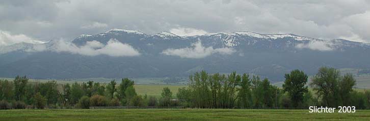
Strawberry Mountain Wilderness
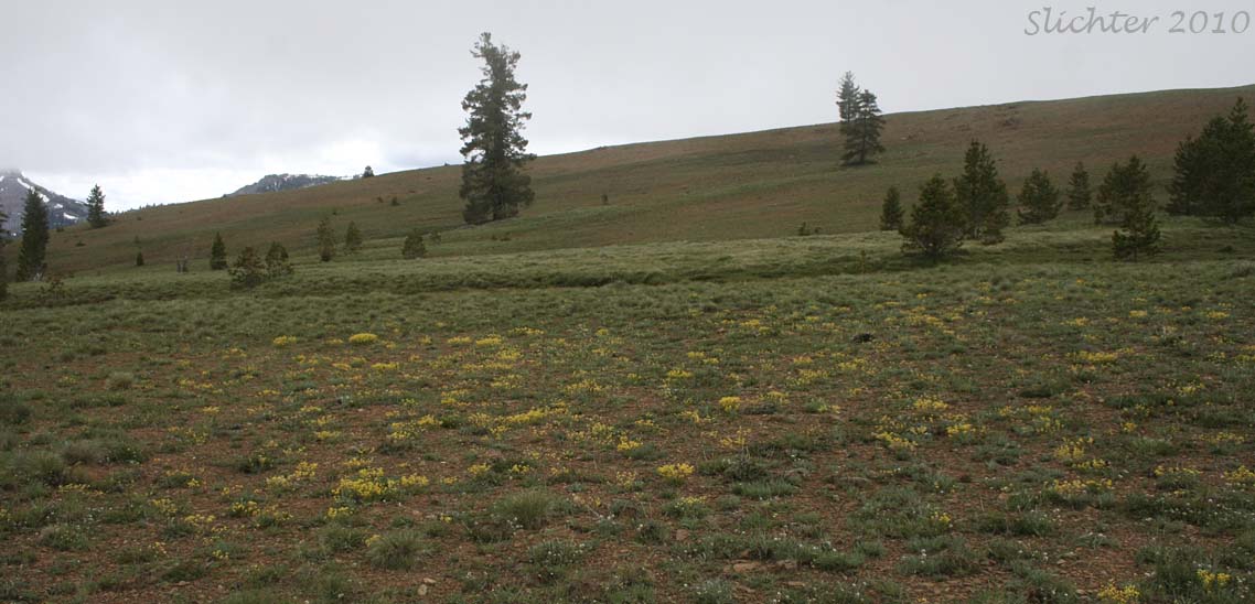
As its name implies, Baldy Mountain is a grassy bald (Idaho fescue and bluebunch wheatgrass) sitting atop a large outcrop of peridotite in the Strawberry Mountain Wilderness Area. Peridotite is an ultramafic rock that has a chemistry similar to serpentine. Consequently, numerous serpentine endemic plants grow here, including the ferns, Shasta fern (Polystichum lemmonii) and podfern (Aspidotis densa). The somewhat rare snowline cymopterus (Cymopterus nivalis) grows in abundance here. The trail winds through an upper montane coniferous forest of grand fir, Douglas-fir, lodgepole pine, and western white pine before emerging onto the bald. A wide variety of plants including the showy Nuttall's linanthus (Linanthus nuttallii), ballhead gilia (Gilia congesta), pleated gentian (Gentiana affinis), Piper's buckwheat (Eriogonum flavum)....one of the more beautiful buckwheats), balloon-pod milkvetch (Astragalus whitneyi), Gordon's ivesia (Ivesia gordonii), and alpine alumroot (Heuchera cylindrica). Other ferns to be seen include northern maidenhair fern (Adiantum aleuticum) and mountain holly fern (Polystichum lonchitus). A side foray can be taken to explore a serpentine fen habitat with felwort (Swertia perennis)! The ultramafic substrate provides for an unusual mix of plants not ordinarily seen together.
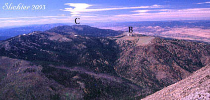
Views from the highest rocky points on Baldy Mt. include a view about 2 miles east to Sheep Rock and Strawberry Mt., Dixie Butte and the Elkhorn and Greenhorn Mts to the northeast and the the broad upper John Day River valley from around Prairie City west to near the town of John Day. Baldy Mt. is lower than the crest of the Strawberry Range so the view to the south includes the forest northern slopes of that range from Canyon Mt. in the west to Indian Creek Butte in the east.
Elevation gain: 1000 ft (from 6000'-7000') from both trailheads.
Hike Length: About 1.5 miles to the crest of Baldy Mt. If planning a day trip, expect to hike about 6-7 miles RT from either trailhead.
Trail from the Northern Trailhead: From the parking area, follow the spur road back to the main road. Turn west onto what becomes FS Road #811. Very quickly one should come to a short spur road on the south side of the main road which is gated. This spur road heads up towards the Chambers Mine. Pass through the gate and follow the road which switchbacks uphill, generallly trending south. At one of the swithchbacks a trail will head east through open forest from the road (may be unsigned?). This should descend slowly downhill before leveling out. Look for forest plants as well as riparian plants as the trail crosses several small streams which descend steeply towards the north. The trail should switchback and head uphill to the west after about one-half mile. As it climbs, the forest should diminish and begin to open up. Within another half-mile, the trail should begin to crest the ridgeline of Baldy Mt. as the trail begins to trend southward. At the ridgeline, the trail will continue to climb gradually to the southeast. At the top of the ridge, one can see the trail descending gradually towards the east (where it eventually joins with Trail #201 in about a mile). The trail can be followed or one can explore off trail from this point (Groups should spread out rather than following single file to protect the plant life.).
Trail #201: From the trailhead on the north side of the bridge at the south trailhead, hike uphill following a sometimes faint track that mostly trends eastward. The slope is moderately steep but there are numerous wildflowers to be viewed in the forest openings when a momentary rest is needed. The trail may not be currently maintained, so one may have to venture off trail around large conifers that have fallen across the trail. After about three-quarters of a mile, the trail makes several switchbacks as it begins to emerge from the forest onto open serpentine slopes. This contains some of the steepest sections of trail. The few trees are mountain mahogany and whitebark pine with some wind sculpted douglas fir. The ground cover is unique to the serpentine slopes here. After about one mile, the trail flattens out and meets a junction. Trail #201 continues to the southeast climbing to a ridgeline which if follows in a meandering fashion. It eventually will pass Indian Creek Butte and Wildcat Basin before arriving at a junction with Trails #713 (Roads End Trail) and #368 (Onion Creek Trail) about one mile south of Strawberry Mt.
The trail to the left passes across grasslands of Idaho fescue and bluebunch wheatgrass with numerous spring wildflowers for about one mile before descending to the northern trailhead of Baldy Mt. One can carefully explore off trail (Groups should spread out rather than following single file to protect the plant life.) along the ridge that makes up Baldy Mt. to both the east or west.
Proceed east from John Day, OR (or west from Prairie City, OR) on US Highway 26. Turn south on paved Grant County Road #54 which parallels Pine Creek to the east. After several miles the pavement ends as the road enters a narrow canyon. The road changes to FS Rd 5401 and shortly begins to climb uphill. Continue along a series of switchback loops with small cabins along the road before entering Malheur Forest lands as the road begins to level out. To this point, the road has decent tread although it can be narrow and becomes rocky in spots........watch for oncoming traffic although that is rarely encountered.
Northern Trailhead:
FS Rd 5401 flattens out and a spur road should quicklly trends northward to a loop with numerous parking places surrounding a vault toilet (It's wise to bring your own TP........just in case.). This is the trailhead for the northern approach to Baldy Mt. One can also continue to drive west to the southern trailhead on Forest Service Road #811 (described below). The driving distance to this point is approximately 15 miles (30-40 minute drive) from John Day, OR.
Southern Trailhead:
Continue on the main gravel road heading west past the northern trailhead parking area, then quickly past the gated road to the Chambers Road. The road heads westward at first before heading south and finally back to the east near the head of Pine Creek. Low slung passenger cars can drive this section (slowly) but drivers should be alert for large rocks that have fallen onto the road as well as rocky bumps in the road (The webmaster nearly high-centered his Honda Civic on such a bump in 2010). SUVs and pickups with higher clearance are better suited for this section of road. Park at the trailhead (unsigned with room for 2-3 vehicles) on the north side of the bridge over Pine Creek, or cross the bridge to park near the trailhead for West Pine Creek Trail #200 which is next to the Celebration Mine. A number of interesting wetlands plants can be seen along Pine Creek just south of the bridge.
June 22, 2011: Baldy Mt. - A Native Plant Society of Oregon Field Trip
June 3, 2011: Pine Creek Road to near the Pine Creek Trail 201 Trailhead (north trail access to Baldy Mt.).
July 2, 2010: Baldy Mountain - Strawberry Mt. Wilderness
July 16, 2003: Baldy Mt., Strawberry Wilderness, Malheur N.F.