Strawberry Mt. Wilderness
Strawberry Mt. is the 9038' peak which dominates the skyline in the 107 square mile Strawberry Mt. Wilderness to the south of Prairie City, OR. From the Roads End trailhead (the second highest road for general passenger vehicle traffic in Oregon.......the Steens Mt. summit is highest.), the hike is moderately easy due to the level trail until one reaches the scree slopes at the southeast corner of Strawberry Mt. The trails that approach the eastern and northern slopes of the mountain are more difficult for their entire length due to trail length and steepness. Because the south approach is fairly easy, it is good trail for hikers with less hiking ability (although the high altitude should be considered!). The area is generally hikeable from July through October.
Numerous species of wildflowers grow along the first few miles of the trail, and once the climb up the east side of the mountain begins, a different set of wildflowers will be seen.
Meadow Flowers: ballhead waterleaf (Hydrophyllum capitatum var. alpinum), Nuttall's linanthus (Linanthus nuttallii), and old man's whiskers (Geum triflorum)
Wetland Flowers: elephant heads (Pedicularis groenlandica), Lewis' monkeyflower (Mimulus lewisii), ranger's buttons (Sphenosciadium capitellatum), rose willowherb (Epilobium obcordatum), subalpine daisy (Erigeron glacialis), tall mountain shooting star (Dodecatheon jeffreyi), and Tiling's monkeyflower (Mimulus tilingii)
Open Forest Flowers: California jacob's ladder (Polemonium californicum), hairy arnica (Arnica mollis), rocky mountain sunflower (Helianthella uniflora), and steer's head (Dicentra uniflora)
Flowers of Rocky, Open Slopes: alpine mountain trumpet (Collomia debilis), alpine springbeauty (Claytonia megarhiza), balloon milkvetch (Astragalus whitneyi), elegant polemonium (Polemonium elegans), glandular paintbrush (Castilleja glandulifera), Hayden's aster (Oreostemma alpigenum var. haydenii), mountain monardella (Monardella odoratissima), roseroot (Sedum rosea ssp. integrifolium), Rydberg's arnica (Arnica rydbergii), silky phacelia (Phacelia sericea), small pincushion beardtongue (Penstemon procerus var. formosus), and trifid mt. daisy (Erigeron compositus).
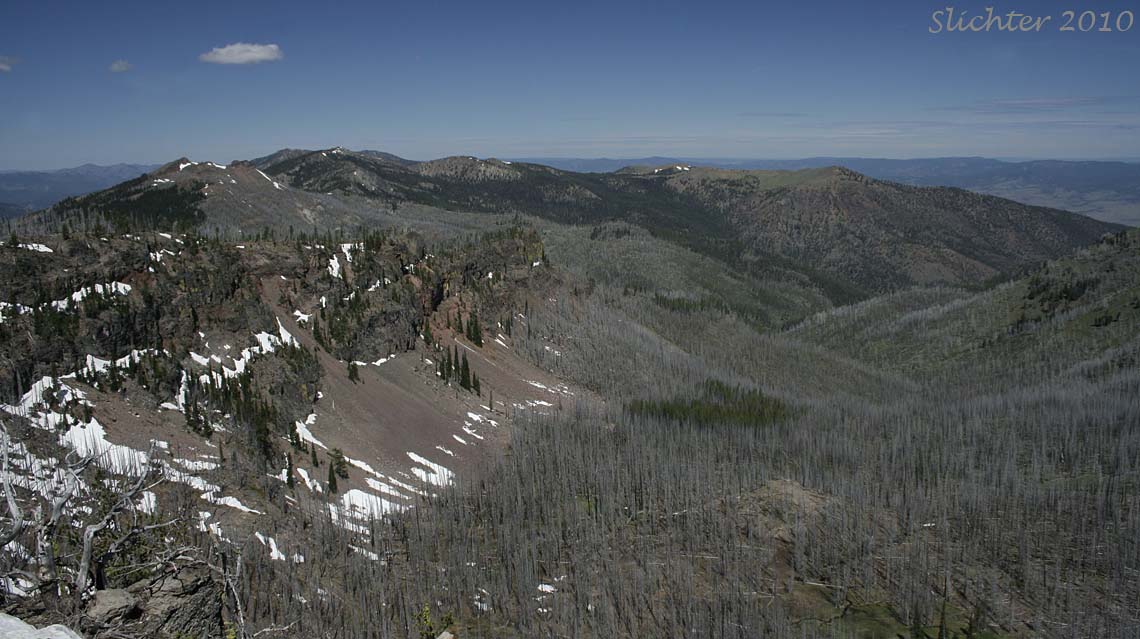
For well conditioned hikers, the south approach can be done in one-half day, although two-thirds of a day might be more normal for average hikers. The north trailheads probably should be considered full day hikes for most of us. For those who arrive at the summit of Strawberry Mt., the views are 360 degrees with views west to the Cascade Mts. of northern Oregon and southern Washington (best seen early in the morning or at sunset before it gets too hazy), north to the Greenhorn and Elkhorn Mts. with the Wallowa Mts. visible far to the northeast on the horizon. The Steens Mt. can be seen far to the south on the horizon (again, best seen early or late in the day) while Snow Mt. with its small snow patch can be seen in the distance to the southeast. The upper John Day River Basin is prominent just to the north and northwest while the Bear and Silvies Valleys can be seen to the south. Logan Valley is not visible from the summit. The Strawberry and Aldrich Ranges extend westward into the distance.
From John Day, OR:
From John Day, drive south on US Highway 395. Turn left onto Grant County Rd #65 (just before the point where 395 begins its winding ascent of Star Ridge. Road #65 is paved but has some deceptive curves so adjust your speed accordingly. The road eventually becomes FS Rd 15 at the forest boundary. Upon reaching the paved FS Rd 16, turn left and drive east until a junction with FS Rd #1640 is reached. Turn north onto FS Rd 1640 which is gravelled but should be in good condition. Drive north uphill for about 9.5 miles until reaching the Roads End Trailhead at a broad switchback in the road.
Driving uphill and east from the trailhead affords access to the Skyline Trailhead #385 for High and Slide Lakes. The upper stretches of FS Rd 1640 may be blocked by deep patches of snow until late June or early July in a typical year. Contact the Malheur National Forest for current road information early in season, or during high snowfall years.
From Prairie City, OR:
From Prairie City, drive south on Grant County Rd #62 which becomes FS Rd 14 at the forest boundary. The road is paved and in good shape but can be somewhat windy, so adjust your speed accordingly. Logging trucks and private road maintenance trucks may be encountered during week days (at all hours), but traffic is generally light. At Summit Prairie, turn sharply westward onto FS Rd 16. Drive west through broad and open Logan Valley on the mostly straight and paved FS Rd 16. Watch for animals on the road. About 2 miles or so west of the western edge of Logan Vally, turn left (north) onto FS Rd 1640 which is gravelled but should be in good condition. Drive north uphill for about 9.5 miles until reaching the Roads End Trailhead at a broad switchback in the road.
From Seneca, OR:
Drive east from Seneca on paved FS Rd 16 for about 14.5 miles. Just west of Logan Valley, turn north onto FS Rd 1640. This road is gravelled but should be in good condition. Drive north uphill for 9.5 miles until reaching the Roads End Trailhead at a broad switchback in the road.
Roads End Trai l #201A: The trail is an old access road which is slowly naturalizing. Hiking and horse riding are allowed uses. Mt. bikes and ATVs are prohibited. Sufficient water should be carried, especially after the snow patches have melted. If thunderstorms are predicted, keep an eye downwind of the cloud movement to watch thunderhead development. Violent thunderstorms can form quickly along the ridgetops here.
Hike north from the trailhead (slightly below 8000') passing a steep, rocky slope on the east. The trail then turns westward and continues its very gentle grade which undulates briefly up and down along its path. The uphill bank gradually lowers to a point where one can scramble up the rocky slopes to the north. One can ramble cross country along the ridgeline trending eastwards to the top of Indian Spring Butte which affords a view southeast to Slide Lake.
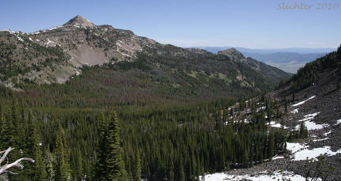
Shortly, the trail bends northwards again. Views are mostly towards the south and southwest across the forested slopes of the southern Strawberry Mt. Wilderness. Various peaks in the southern Malheur National Forest should be visible as well as a portion of Bear Valley in the distance to the southwest. At 1.5 miles from the trailhead, the old road bed ends at a junction just below an elevation of 8000'. The Pine Creek Trail #201 heads west (largely along the ridgeline) while the Onion Creek Trail #368 heads north from the junction. The junction affords a great view north to the southern slope of Strawberry Mt. as well as views northwest across the broad upper basin of the East Fork Indian Creek with the flat, grassy slope of Baldy Mt. visible several miles away.
Continue towards Strawberry Mt. by heading north on the Onion Creek Trail #368. A deep snow cornice may hide the trail just a few feet north of this junction during the first 2 weeks that the southern approach is open. It doesn' last very far, but you will have to make the determination how safe it will be to climb the very steep slope and climb over this snow patch. It helps to bring binoculars if you are familiar with the trail route to scan for additional snow patches, especially high up on Strawberry Mt. as the trail climbs steeply over the steep eastern slopes of the mountain where there are usually other deep snow patches amidst the small mountain trees.
If there is no snow, continue north on the Onion Creek Trail which now passes through open forest, much of which was burned during the Wildcat Fire of 1996. The trail does trend downhill for about one-quarter mile before climbing again to the narrow, rocky pass (8020') at the southeastern base of Strawberry Mt at 2.7 miles. At this small saddle there is a junction with the Strawberry Basin Trail #375C which heads downhill towards the east to Strawberry Lake. Some interesting wildflowers can be found just below the eastern rim of the ridge near this junction.
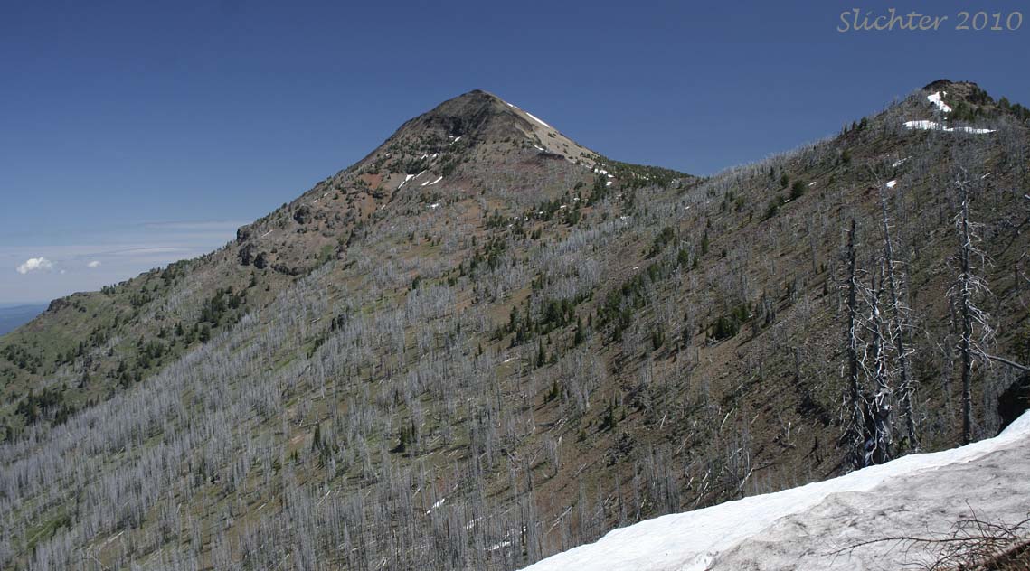
At the junction, keep to the left and continue north on the Onion Creek Trail. The trail now begins a constant climb across the steep, rocky eastern slopes of Strawberry Mt. The climb is mostly above treeline although the trail does pass through some small alpine trees at about 8200' where hike impeding snow drifts may linger late. The talus and scree slopes offer a close-up view of many alpine and subalpine plant species which are more common east and northwards in the Wallowa and Rocky Mts. Once past this point, the trail climbs a little slower until reaching a junction on the northeastern corner of the mountain at 3.25 miles. The right junction is the continuation of the Onion Creek Trail which descends steeply towards the trailhead about 4.5 miles northward. Rocky outcrops around this junction have a different flora, so take a short rest under the shade of the low trees and do some botanical exploration here, or take notice of the stunning view of the surrounding terrain.
To complete the ascent of the mountain, take the left fork from the junction. This short section should be considered most difficult due to the altitude and steepness. The trail climbs very steeply up the northeast ridge of the mountain. It climbs about 800' in half a mile across a rocky, mostly open surface. There are many criss-crossing paths enroute where others have created trails, but the route upward should be easy to follow. The 9038' summit is relatively broad and once housed a lookout. As mentioned above, the views are stunning and widespread. Most days, there will be at least a few others eating lunch here. On sunny, warm and windless days, watch for butterflies spiralling from the summit and watch for swallows or the occasional swift darting by.
August 18, 2011: Strawberry Mountain (Strawberry Mountain Wilderness) from the Roads End Trailhead (Trail 201A)
August 3, 2011: Strawberry Mountain (Strawberry Mountain Wilderness) from the Roads End Trailhead (Trail 201A)
July 1, 2010: Trail 201A from the Roads End Trailhead to the junction with the Onion Creek Trail, then west on the Pine Creek Trail #201. - Strawberry Mt. Wilderness
July 5, 2002: Strawberry Mt. (via the southern access trail)
September 4, 1999: Strawberry Mt., Strawberry Wilderness, Malheur NF
Partial Flora of Strawberry Mt.
 -
-