From Trout Lake, drive north on paved Road #23 (sometimes known as the Mt. Adams Recreational Area Access Road) to the Y-junction about 1.4 miles north, and continue on the left fork which is still Road #23. You eventually will climb more steeply and pass good views of Mt. Adams to the northeast and upon reentering timber about 14.1 miles north of Trout Lake, you will turn right onto Road #521. Continue 0.3 miles to the trailhead.
Directions to the North Trailhead:
From Trout Lake, continue as above on Road #23 past road #521 for another 11.5 miles (the road transitions to gravel and narrows just north of the junction with Road #90) to a junction with paved Road #2329. Proceed right on Road #2329, passing Takhlakh Lake where the road becomes gravel again and then Takh Takh Meadows on the left. forest Road #115 is reached 11 miles north of Rd #23. Turn right onto Rd #115 for about one-half mile to a point where the PCT crosses the road and park in the small lot on the north side of the road.
Directions from Seattle and Tacoma:
Take Exit 133 from Interstate 5 in Tacoma and proceed south for 55 miles along State Highway 7 to Morton, WA. At Morton, drive east on US Highway 12 to Randle. From Randle, turn south onto State Route 131 (may be signed Forest Road #25) for 0.9 miles. Turn left (east) onto Road #23 and proceed uphill to either the junction with Road #2329 (for the north trailhead) or continue south to the south trailhead at Road #521. Depending on traffic, the trailheads are 2-3 hours south of Tacoma.
Alternate Trail Access:
Additional trails access the Pacific Crest Trail from the west and north. These include the Riley Trail #64 on the west (along Road 23) and the Divide Camp #112 and Killen Creek #113 Trails accessed via Road 2329.
High Elevation: 6040'
Trail Length: 23.2 miles one way to Rd #115. Horseshoe Meadows is 5.3 miles from the south trailhead.
Trail Use: Light to moderate. Use is heaviest from the south trailhead to Horseshoe Meadows and also to the north of Adams Creek. A fair amount of horseback travel may be encountered along the trail during weekends and holidays.
Permits: Northwest Forest Passes should be displayed at any trailheads accessing this trail. Wilderness permits should be carried at all times (the PCT is patrolled by forest guards). Cascades Volcano Passes should be obtained for any planned travel above 7000', and those who plan to ascend the west or southwest sections of the mountain should register at the Forest Service Ranger Station at Trout Lake.
Water: Boil or filter all water along this route! Either carry out human and dog wastes or practice good sanitation by burying wastes far from water, to prevent contamination of the lakes and streams along this route.
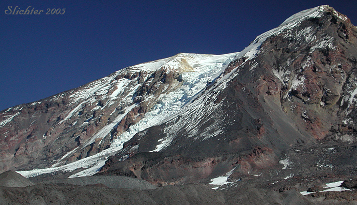
Special Considerations: Water can be scarce after prolonged dry spells late in the summer until early fall along much of the trail. The crossing of Adams Creek can be quite tricky after lengthy periods of heavy rain or long periods of hot weather due to high volumes of silty, melt water coming from Adams Glacier. It may be best to time your crossings of this, or any other difficult creeks for early to mid-morning to avoid the higher water volumes. In addition, black bears may be encountered along the trail, especially as berries ripen from mid-summer on. Store food (and garbage) in sturdy waterproof bags or containers. Using light but strong rope, cast the rope over a high branch in a tree and hoist the food (or your pack/s) so they are about 10 feet off the ground. Upon encountering a bear, stop and face the bear. Give it a chance to move off. If you need to move off, slowly back away, glancing at your footing so you don't trip. If the bear follows, you might also wave your arms, yell, bang metal objects together, etc to frighten it. In 40 years of hiking the area, I've only encountered two bears, and both quickly moved away when they saw me!
September 13, 2008: Pacific Crest Trail From Road #521 to Horseshoe Meadows
September 25, 2005: Pacific Crest Trail from Riley Trail #64 to Crystal Lake