Wildflower Bloom Reports for Previous Years: [2023] [2022] [2020] [2019] [2018] [2017] [2015] [2014] [2013] [2012] [2010] [2008] [2007] [2004] [2002] [2001] [1995-2000]
September 27, 2016: Rock Creek via the Ochoco Mountain Trail #823 hiking north from the trailhead on Road 38. (Ochoco National Forest)
September 25, 2016: Spanish Peak via Road 3800-200 from the trailhead on the east side of the peak for the Ochoco Mountain Trail #823 (Ochoco National Forest. - We walked the road about 1.5 miles to the summit.
September 24-27, 2016: Big Springs Campground (Ochoco National Forest)
August 4, 2016: East Fork Lostine River Trail #1662 From Two Pan Trailhead to Milepost 4.6 (Eagle Cap Wilderness and Wallowa-Whitman National Forest)
August 3, 2016: Maxwell Lake Trail #1674 and at Shady Forest Camp (Eagle Cap Wilderness and Wallowa-Whitman National Forest)
June 12, 2016: North Warner Viewpoint (Fremont National Forest)
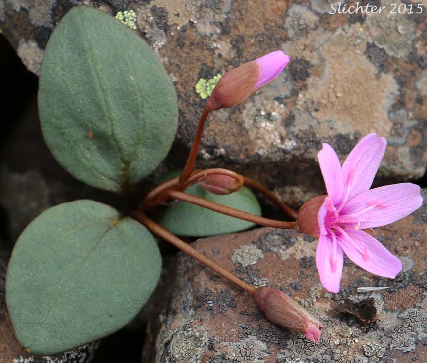
June 12, 2016: Forest Road #3615 from Oregon Highway 140 north to North Warner Viewpoint (Fremont National Forest) - Floral highlights.
June 11, 2016: Bond Creek from Hot Springs Campground (Hart Mountain National Antelope Refuge)
June 9, 2016: Road from Hot Springs Campground to Barnhardi Basin & summit ridge north of DeGarmo Canyon (Hart Mountain National Antelope Refuge)
June 9-12, 2016: Hot Springs Campground (Hart Mountain National Antelope Refuge)
May 27-30, 2016: Ochoco Forest Campground (Ochoco National Forest)
May 29, 2016: Lookout Mountain (Ochoco National Forest) - Accessed via trails 808, 808A and 804.
May 28, 2016: Round Mountain South Trail #805 (Ochoco National Forest)
May 27, 2016: Meadow along Road 4215 and north of the junction with FS Road 4215-100 (Ochoco National Forest)
May 18-20, 2016: Silver Creek Marsh Campground (Fremont National Forest)
May 19, 2016: Hager Mountain via the Fremont National Recreation Trail #160 from the Hager Springs Trailhead (Fremont National Forest)
May 18, 2016: Fort Rock State Natural Area
April 30, 2016: Viewpoint at Rocky Bald North of Junctions of FS Roads #4230 and #920. (Ochoco National Forest)
April 30, 2016: Rocky Balds from FS Road 050 to the Top of a Ridge Southeast of Long Prairie (Ochoco National Forest)
April 30, 2016: Balds and Meadows into Coniferous Forest Along FS Road #42 at the Junction with FS Road #42-300 (Ochoco National Forest)
April 29-30, 2016: Ochoco Forest Campground and upstream 200 meters east of the Group Camp, and one-quarter mile north of the Forest Service workshop buildings. (Ochoco National Forest)
April 29, 2016: Riparian Meadows & Rocky Balds at the Junction of FS Road #42 & FS Rd #3010 (Ochoco National Forest)
April 29, 2016: Meadows and Uplands on North Side of Johnson Creek Along FS Road #42 ( (Ochoco National Forest)
April 9, 2016: Cottonwood Canyon State Park: South River Trail, East Bank of the John Day River from JS Buress State Park to the Esau Corral (Gilliam County)
March 18, 2016: Cottonwood Canyon State Park: Slope west of the Day Use Area, from the Sage Knob Trail uphill to the top of the rim.
February 20, 2016: Cottonwood Canyon State Park: South River Trail, East Bank of the John Day River from JS Buress State Park to the Esau Corral (Gilliam County)