 -
-  -
- Angel's Rest was another of my favorite gorge hikes, as it is within a one-half hour drive of Portland and has many fine views of the western Columbia River Gorge. Another attraction is that it is a great place to view a wide variety of wildflowers, with over a hundred species visible along the trail from late April through May. The trail is hikeable in all seasons but can be dangerous with ice and snow on it, and can be muddy and slippery after wet weather. The trail is very popular now and if you can arrive early during a week day, this would be the best time for a wildflower hike.
Note: I haven't hiked this trail for more than a dozen years now since it is crowded at any time of year, and because of the difficulty in finding a parking place. Please refer to the online resources below for more current trail information.
 Directions:
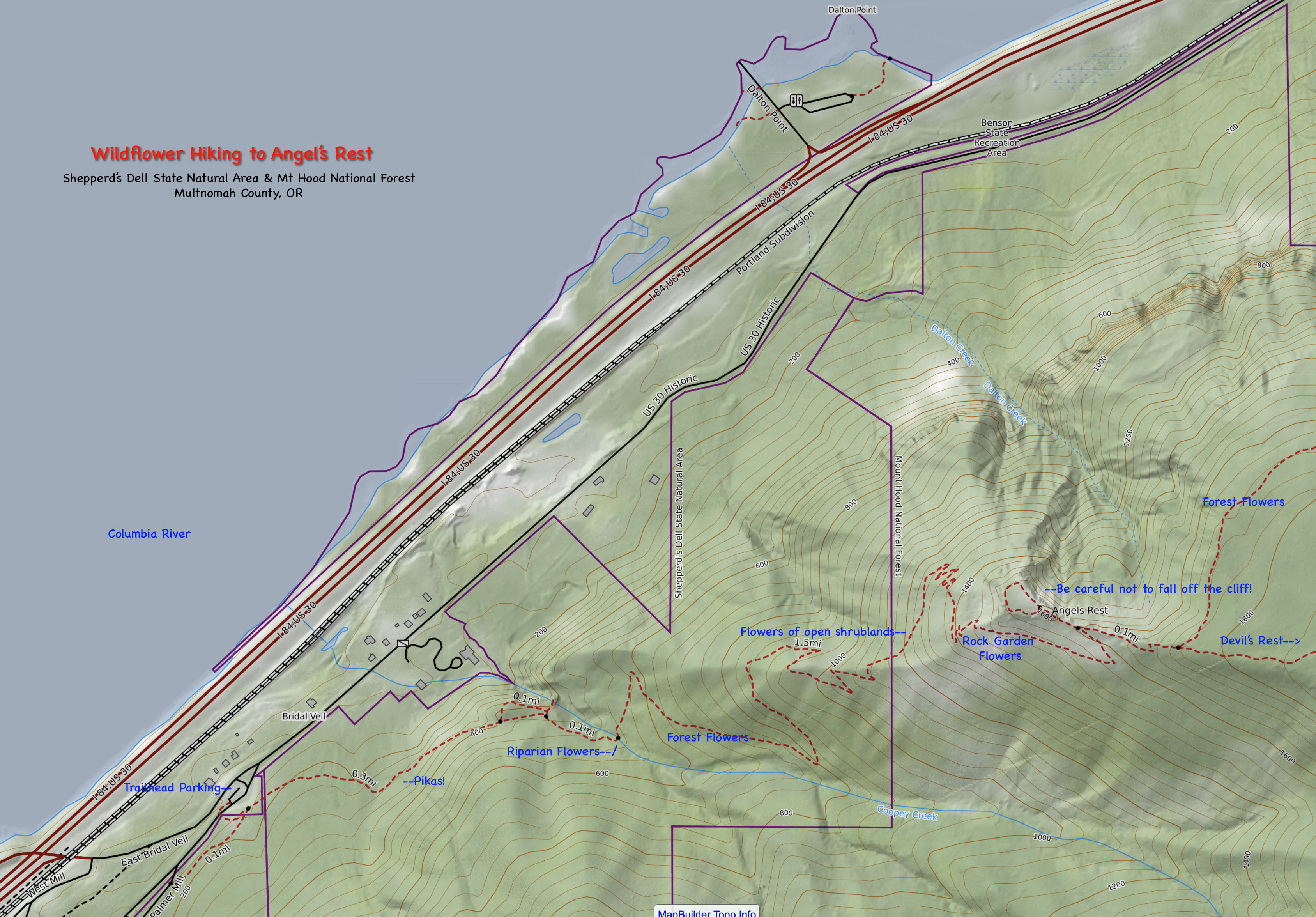
For eastbound traffic on Interstate 84 east of Portland, take the Bridal Veil exit (Exit 28). Proceed uphill to the intersection with the Columbia River Gorge Scenic Highway. Turn right at this intersection to park either immediately on the right in a newly built parking area or proceed 50 yards uphill and turn left into another overflow parking area.
If approaching from the west on the Columbia River Gorge Scenic Highway, the Angel's Rest trailhead is approximately 5 miles east of Crown Point.
For westbound traffic, exit at the Ainsworth Exit (Exit 35) and proceed about 7 miles west along the Columbia River Gorge Scenic Highway to the parking area.
Both parking lots are frequently full by 8am on weekends and 9am on weekdays. People then illegally park in chaotic fashion along the Scenic Highway, which will net you a hefty fine if the sheriff drives by!
The trailhead is on the uphill side of the scenic highway. The trail to the summit of Angel's Rest is approximately 2 miles long and is fairly steep. In rainy weather, the middle and upper sections can get fairly muddy and slippery so proceed with caution. Hike uphill, soon crossing an open, rocky slope where the flower species which like rock garden conditions may be found. These include Oregon stonecrop and woodland Phacelia.
The trail continues upwards, soon crossing a creek via a bridge. At this point, the trail begins a series of long switchbacks, first above the creek on the west facing slopes of Angel's Rest and then eventually along its north-facing slopes. At this point you begin entering the forest burned about 10 years ago in a fire which originated just above Multnomah Falls. A number of snags still remain but the understory of shrubs and young trees have quickly begun to erase many vestiges of the fire.
As one nears the top of Angel's Rest, common flowers that are passed include Columbia tiger lily, mountain Arnica, Oregon flag, and oval-leaf Viburnum. At this points, tantilizing glimpses of the summit are seen close at hand. You know you are close as you scramble over another, flatter talus field. After another switchback, a small saddle is reached. Taking the trail to the right procees to Devil's Rest and eventually to Wahkeena Falls or Multnomah Falls. Hiking to the left, one proceeds along the narrow ridgetop, scrambling over some large boulders to the viewpoint.
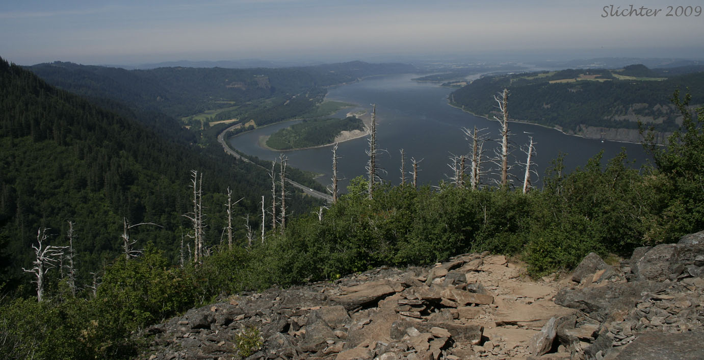
The elevation of Angels Rest is about 1600 feet. The views are wide and pretty, with views back towards the Sandy River in the west, the cliffs of Cape Horn across the river to the north and Silver Star Mt. on the far horizon further north. To the east, one can see much of the river towards Beacon Rock (although the latter is hidden by the steep slopes on the Oregon side of the river. The summit is a good spot for a picnic, although it is exposed to rain and the infamous gorge winds. Please refrain from throwing rocks from the summit as the trail is directly below the north side! With luck, you may see violet-green swallows, Vaux's swifts or turkey vultures sailing by along the edge of the summit. Wildflower species which may be found atop Angel's Rest include blue-eyed grass, Oregon flag, little goldenrod, and Scouler's hawkweed.
Take note that there is quite a bit of poison oak along the trail so be careful to look where you will be resting or as you step to the side of the trail to let others pass. In addition, the slopes along the trail are very precipitous so stay on the trail and keep dogs on a leash!
Comprehensive Plant List for Angel's Rest
Angel's Rest: Nortwest Wildflowers
Angel's Rest Trailhead: OregonHikers.org - Contains good suggestions for finding and parking at the trailhead.
Angel's Rest Trailhead: Oregon State Parks
Angel's Rest Hike: Oregon Hikers.org
Angel's Rest: Washington Trails Association
Angel's Rest: Friends of the Columbia Gorge
Angel's Rest Trail #415: US Forest Service
Angel's Rest Devil's Rest Loop Hike: OregonHikers.org
Angel's Rest-Devil's Rest Loop: Washington Trails Association
Angel's to Devil's Rest Loop: Friends of the Columbia Gorge
