The Highline Trail #114 does not have a trailhead linked to a road on it. Instead, hikers must use the trailheads for the Divide Camp Trail #112 (5.2 miles), Killen Creek Trail #113 (4.3 miles) or Muddy Meadows Trail #114 (4.3 miles) to reach the Highline Trail. If your goal is the northeast side of Mt. Adams, then the Muddy Meadows Trail affords the easiest access as it gives access that is over 2 miles closer to the east side of the mountain than the other 2 trails.
Access across the eastern slopes of Mt. Adams in the Yakama Reservation are generally cross country. Trail access existed over 40 years ago (with a major detour east), but most of these routes are now overgrown, and the crossing of the Big Muddy Creek presents problems if crossed too far down stream because of large volumes of glacial melt waters. Further complicating the problem of this north-south traverse of eastern Mt. Adams is the north-facing, steep talus slopes of the Ridge of Wonders which is dangerous due to both rock fall and treacherous footing on the 1000' vertical climb or descent, while further east, the slopes are still steep but densely timbered and very brushy. Perhaps the easiest route across the east side is achieved by traversing south from Avalanche Valley to the moraines at the base of the Klickitat Glacier, and then traversing upslope to Sunrise Campat 8300', and then across the base of the Mazama Glacier to the climbers trail down to Bird Creek Meadows. The result is that this traverse of the eastern slopes of Mt. Adams should only be attempted in good weather by experienced hikers with good route finding skills. Emergency services are a full days hike away, and cell phone service would be questionable here, perhaps only working in the Devils Garden or at Sunrise Camp.
Elevation at the Muddy Meadows Tr: ~5840'
Elevation at Foggy Flats: ~5960'
Elevation at the Devils Gardens: ~7760'
Elevation at Avalanche Valley: ~6600'
Length of Trail:
PCT to Muddy Meadows Tr - 2.2 miles
Muddy Meadows Tr to Foggy Flat - ~1 mile
Foggy Flat to the Devils Gardens - ~3.8 miles
Devils Gardens to Avalanche Valley - ~2 miles
Trail Use: Light. Even on holiday weekends, traffic on this trail is light, with the bulk of traffic going to Foggy Flats and campsites uphill within its basin or the ridges surrounding it. Horses will use the trail, especially in the loop between the PCT and Muddy Meadows Trail.
Permits: Display your Northwest Forest Pass on the dashboard or mirror of your parked vehicle at whichever trailhead you have used. Register and carry the wilderness permit as you hike. Forest guards will be more common along the trail to the west of Foggy Flat. If you proceed up to the Devils Garden, or the ridges high above Foggy Flat, you may wish to purchase a Cascade Volcanoes Pass at one of the local Rangers Stations (Trout Lake or Randle). If you hike into Avalanche Valley, you may wish to get a pass from the Yakama forest guards stationed in Bird Creek Meadows.
Water: A large, clear stream runs along the eastern edge of Foggy Flat which provides water throughout the season. Several small streams provide water during the first few weeks of summer between Foggy Flat and timberline, but these dry up quickly. Two branches of the Muddy Fork cross the trail, but these are filled with glacial silt, so could clog a filter. The trail runs for over a mile between these 2 creeks, so look for small seeps of clear water trickling from the base of the glacial deposits for water later in season. No water is available between the easternmost branch of Muddy Fork and a stream coming off of Wilson Glacier near Goat Butte. This would be a very dry span of 4 miles, especially during dry weather! As I have not been beyond the Devils Gardens, I'm assuming that several of the creeks coming off of the Wilson and Rusk Glaciers in the Goat Butte and Avalanche Valley area will be clear.
Camping: There are several nice campsites around the edges (and above) Foggy Flats. A mile up the Highline Trail there are several other nice campsites at the point where the trail crosses a small early season stream and begins to enter open, sandy areas. Between this point and the Devils Garden, adequate campsites are few and far between and either lack water or will be very exposed. Camping on the numerous mats of low wildflowers would be discouraged due to threat of destroying these plants. On Yakama lands, campsites would generally be limited to those which currently exist in Avalanche Valley. Campfires are not permitted above 6000', which is the entire area above Foggy Flats.
Special Considerations: This area is about as remote as you will get on Mt. Adams. Hikers need to be very self-reliant and prepared for all types of weather and safety issues. Above timberline, the ground is generally either loose glacial sand, gravel and gravels, or small to large lava boulders which can make for difficult traction. Exposure to sunshine is high, even on overcast days so dress accordingly, wear good quality sunglasses, and bring and use your sunscreen. Thunderstorms may build on any side of the mountain during late afternoon into the evening from mid-May through mid-September, and the buildup may go unnoticed as it is on the other side of the mountain. If the mountain top gains a cap of clouds that begin to descend, that may be a clue that inclement weather may be coming. Mosquitoes and biting flies will also be a problem for the first month or so of the season.
In terms of safety, the most pressing issue for hikers and campers is safely fording the 2 major branches of the Muddy Fork. The western-most branch is generally the easiest to cross, and can usually be done by rock hopping. The eastern branch is wider with more volume and may be waded, especially in the afternoon or during prolonged warm weather. Also look for snow bridges early in the season for your crossing. Take care though that the snow depth on the bridge is great enough to support your weight so you don't break through. You could also trek uphill to the foot of the glacier and cross there, but that involves an hour or more extra time in route finding.
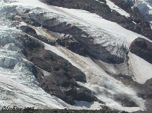
The second major safety issue concerns rockfall and icefall from high elevations on the mountain. It is perhaps easiest to get close to the main bulk of the mountain on its north side (something I wouldn't recommend!). However, a constant rain of rock tumbles down the mountain here and an occasional section of a hanging glacier breaks free 1-2000' higher on the mountain (which is occurring too frequently with the short winters and warm summers since 2000). The rumble of rockfall and roar of icefall is a constant most summer days, and occasionally through the night hours on most sides of the mountain.
Access From Avalanche Valley to Bird Creek Meadows:
Until the late 1960s, the immediate east side of Mt. Adams was controlled by the US Forest Service and trails from the east and southeast into Avalanche Valley were maintaned. I've seen a number of photos which show pack trips into this region from that day and age. Now under the jurisdiction of the Yakama Nation, I'm unsure whether the aforementioned trails remain, and generally if they do exist, they wouldn't be usable fornon-Yakama visitors. To arrive at Avalanche Valley from the south, one would need to park at the Bird Creek Meadows parking area, then hike along the climbers trail across the terminal moraines and across the foot of the Hellroaring Glacier to the climbers camp. Trails then descend to the north of the Ridge of Wonders across cinder and loose talus slopes. It is reccomended that backpackers cross the Big Muddy either early in the day or high up along the moraine before traversing northeast along the northern moraine and then north into the Avalanche Valley drainage.
Note:
Due to heavy flooding in November 2006, the crossing of the Big Muddy was very difficult. The torrent washed a large volume of cinders and rocks from this large creeks banks so that those who did make the crossing had to use ropes to descend from the moraine down the sheer drops into the creek bed and then make a hazardous climb up the opposite bank. It may take several years for these slopes to stabilize so those of us with less technical skills can make the crossing.
The following description of the route that the Highline Trail follows will be listed from west to east.
If you have arrived at the meadows of Killen Creek, you have probably hiked in via the Killen Creek Trail. From Killen Creek (where there are a number of attractive campsites plus water throughout the season), hike north on the Pacific Crest Trail for about 0.2 miles to the junction with the Highline Trail which is on the right. Continue onto the Highline Trail, which may be suffering from erosion here as it climbs to the northeast. The trail climbs about 300 feet during its first mile before descending to about 5860' and then veering east during the next 3/4 mile. The junction with the Muddy Meadows trail is reached after about 2.2 miles of hiking. This portion of the trail is largely in coniferous forest, but opens up with some small sandy clearings at its eastern end.
Proceeding east of the Muddy Meadows Trail junction, one turns southeast and climbs slowly through forest and moist meadows filled with wildflowers early in the season, reaching Foggy Flat (~5960') in about 0.8-1 mile. The meadow here is fairly broad and flat with a small stream meandering through it on its west side, and a larger clear stream at its eastern edge. Mt. Adams can be seen from the northern fringe of the meadow. I'm assuming that camping is discouraged in the meadows, and as at all areas above the PCT and Highline Trail, campfires are prohibited. I have not extensively explored this meadow and surrounding hillsides, but have heard that there are a number of good campsites in this area. If you hike further up the Highline Trail, fill your water bottles here as chances are that water will not be found between here and the far side of the Devils Gardens, several hours away.
Proceeding southeast across the northern edge of the meadow, you ford the larger stream and then switchback up the open hillside to then climb at a more gentle rate. The trail leaves the forest rather abruptly within a mile. The timberline area offers several good campsites under the trees (no water) and your first excellent views of Mt. Adams itself. This also marks a transition zone for foliage, as many small alpine plants become abundant here. Stay on the established trail above this point to protect the fragile plants. After crossing several small ridges, you will begin to hear water. You will cross the western-most branch of Muddy Fork at about 6300' about one-half mile above timberline. The glacial melt water runs fast and high here but the crossing often can be done by hopping rocks. The crossing here and at the next creek is much easier when done from early morning to an hour or so before noon. After you cross the stream, look for rock cairns to regain the route. Follow these upwards on a gravelly silty path that meanders up onto some of the eroded ridges which are the result of glacial outwash. Watch your footing here as it can be tempting to look for the attractive plant life here! The path meanders about another mile up to about 6900' (above a rocky point on the east side of the creek, with shear cliffs eroded by the creek) before the ford is reached. Note the cairns on the other side of the creek so you can find the route once you have crossed, then search for the best crossing, either by rock hopping, wading, or crossing on snow bridges that persist on east-facing slopes along the creek.
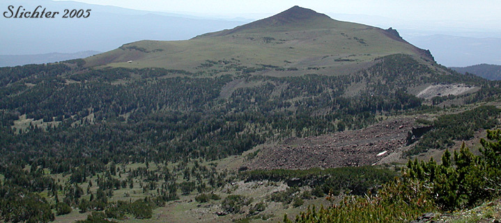
The trail takes a more easterly course on fairly level ground for about a quarter mile before meandering uphill around various vestiges of an old lava flow. The trail then passes through krummholtz whitebark pine and fields of silky lupine (Lupinus sericeus) before veering south along the western crest of the ridge to your left, which is quite rocky above. This marks another transitional area in terms of vegetation. During your rest stops, scan the moraines between the trail and the mountain for mountain goats, which can be quite numerous here. The path in this area generally is sandy to gravelly, but the tread is quite good and it is possible to make good time. Soon the trail veers east again and winds through the rocky areas at the crest of the ridge (at about 7760'). There are interesting rock formations to investigate here, and the area known as the Devils Gardens are evidently upslope to your right. This marks another area of different plants, which often bloom early because the area is swept of snow by exposure to winds. In fact the plants may be missed because the lower trail sections will still be snowed in.
The eastern edge of the Devils Gardens offers good eastern views into the upper Klickitat River basin as well as to Goat Butte. The view up to the Wilson and Rusk Glacier about a mile away are also spectacular.
I have not been further into the Yakama Reservation at this point, but apparently the trail descends steeply between a cliff and snowfield then crosses a gentler slope keeping roughly to the 7000' contour. Two creeks which descend from the Wilson Glacier are crossed before the trail climbs again slightly into the notch between Mt. Adams and Goat Butte and then descends to the campsite in Avalanche Valley at about 6600'.
I should point out that is possible to hike from the Muddy Meadows trailhead up to the Devils Gardens and back again and still have time for some serious botanizing and photography, but this would mean getting to the trailhead early and requires a hike of about 19-20 miles for the day! The return trip from the Devils Gardens requires about 3 1/2 to 4 hours of largely uninterrupted hiking, so time your return accordingly to arrive at the trailhead at or before sunset! Obviously, my recommendation is to backpack in and spend several days exploring the area.
July 24, 2005: Devils Garden
July 23, 2005: North Side of Mt. Adams above the Highline Trail #114 below Lava Glacier
July 11, 2005: Highline Trail #114 from Muddy Meadows Trail #13 to ~7460' (below the Devils Garden)