Malheur National Forest
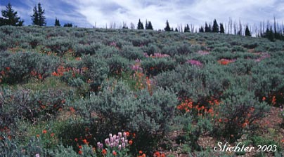
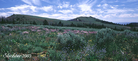
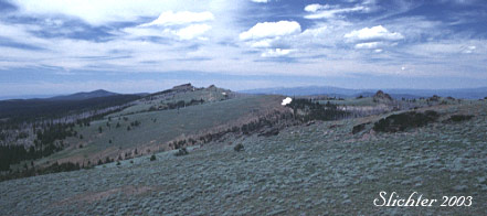
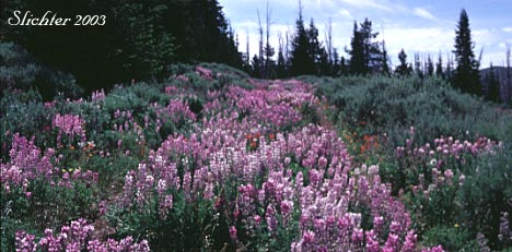
The Monument Rock Wilderness is a 31 square mile wilderness located about 26 miles to the southeast of John Day, OR. Monument Rock, Bullrun Rock, and Table Rock are part of a broad plateau covered with a mix of habitats, including rabbitrush, some conifer (the area was burned in 1989), and good stands of riparian habitat, including quaking aspen. The lookout atop Table Mt. includes good 360 degree views of the area and is a good spot to begin a trip to this wilderness. One can look southwest and downhill into the upper Little Malheur River basin from several locations while there are ample locations to look eastward past the arid lands around Unity, OR. The open areas between Table Rock and Bullrun Rock are often densely covered with lupines and paintbrush early in season, while the rabbitbrush and sagebrush provide ample color late in the summer to early fall. Warm days in late June through July should allow ample butterfly viewing.
Floral highlights include: Cusick's serviceberry (Amelanchier cusickii), dwarf larkspur (Delphinium depauperatum), elephantheads (Pedicularis groenlandica), Gairdner's penstemon (Penstemon gairdnerii), Nevada lewisia (Lewisia nevadensis), orange agoseris (Agoseris aurantiaca), Oregon catchfly (Silene oregana), sagebrush bluebells (Mertensia oblongifolia), shrubby penstemon (Penstemon fruticosus), silky phacelia (Phacelia sericea var. ciliatum), subalpine daisy (Erigeron glacialis), western blue flag (Iris missouriensis). Plants that bloom from late summer into early fall include: Green's goldenweed (Ericameria greenii), green rabbitbrush (Chrysothamnus viscidiflorus) and mountain big sagebrush (Artemisia tridentata var. vaseyana).
Trail Length: 1.8 miles, one way.
Elevation: 7000-7500'
Rating: Easy on trail, Moderate to Difficult off trail
Season: June to October
Allowed Activities: Hiking and horse use. ATVs and mountain bikes prohibited.
Use: Light, Moderate during hunting season.
The wilderness may be accessed from US Highway 26 by turning south in downtown Prairie City at a sign for Depot Park. After 0.4 miles, turn left at a stop sign and continue on what becomes County Road 62. After about 8 miles, turn left onto FS Rd #13. Continue on this paved road for about 11.5 miles until an intersection with FS Rd #1370 (gravel) is reached. Turn left (east) onto Rd #1370. After about 4.4 miles, turn left to remain on Rd #1370. After another 1.5 miles, turn right following a sign denoting Table Rock L.O.. After 0.2 miles, pass the entrance to Elk Flat Spring CG on the right (outhouses). The remaining 3.8 miles become narrower and rocky. Early season visitors may have difficulty with low slung passenger cars until the road is graded (if that occurs anymore). In 2011, the last couple of miles of road were pretty rough until the switchback was reached. Approximately 3.8 miles past the campground a switchback to the left is reached. Park here for the hike into the Monument Rock Wilderness, or proceed left up the hill to Table Rock Lookout. The road up to the lookout used to be pretty rocky but seems to have been improved so that most vehicles can now make it to the top.
Access by vehicle is limited from late May (at the earliest) to late Fall due to snowfall. I'm guessing that good wildflower displays normally begin in mid to late June and these can extend into early September, at least after winters with high snowfall.
There's a signed trailhead with room for 3 or 4 cars at most at a sharp switchback to the left (when viewed from downhill) of the road, about half a mile downhill from the summit of Table Rock. Park here to hike south into the wilderness. It is well worth your while to park here and then walk along the road up to the lookout.
An old dirt road travels about 1.8 miles south through the wilderness to Bullrun Rock from the signed trailhead. This is the Table Rock Trail #365. From Bullrun Rock one can bushwhack about a mile to the southwest to Monument Rock, which is topped by an old rock cairn which was perhaps built by early sheepherders. Springs at the heads of Bullrun Creek and Rock Creek provide water in spring and fall. The riparian areas of these 2 streams provide an interesting set of plants in contrast to the more arid selection of plants in the surrounding area. For a longer trip, one can head follow the trail east downhill from Bullrun Rock and then follow the mostly open ridgeline of Bullrun Mountain trending mostly northeast for as long as one wants. Because of the openess of the terrain, distances while hiking cross country can be quite deceiving here. There are plenty of ups and downs to negotiate and because of the amount of sagebrush and goldenweeds, one tends to walk about twice as far as they think when navigating around the low shrubs here.
A partial flora of the Monument Rock Wilderness
August 2, 2011: Monument Rock Wilderness
July 6, 2002: Monument Rock Wilderness, Malheur National Forest
September 5, 1999: Monument Rock Wilderness, Malheur National Forest
 -
-