Malheur Ford Camp to Hog Flat
Malheur National Forest
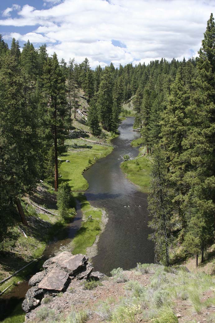
The Malheur River National Scenic Trail follows the upper Malheur River, passing through coniferous forest and passing near riparian meadows for its 7.8 mile length. The river is shallow and 20-20 meters broad, although not easily fordable. It is a favorite destination of fly fishermen. This moderately difficult trail looses about 600 feet in elevation and is hikeable from mid June through early October. The best wildflower bloom occurs from early June into early July. Most of the trail meanders on a gentle grade within a narrow to moderately broad canyon lined with basalt rimrock. The last mile involves a moderate climb uphill and probably has some of the best wildflower display. The trail can be hiked as an out and back or it can be hiked in its entirety if a car is left at both trailheads.
Floral highlights include ballhead waterleaf (Hydrophyllum capitatum var. capitatum), heartleaf arnica (Arnica cordifolia), hooked-spur violets (Viola adunca), old man's whiskers (Geum triflorum) as well as large, old growth ponderosa pine (Pinus ponderosa), western larch (Larix occidentalis) and white fir (Abies concolor x Abies grandis). Wildflower bloom peaks from mid-May to late June downstream. It is a week or two later nearer the upper trailhead.
Birding should be great in the morning and evening with numerous kingfishers, warblers, woodpeckers, and other birds that hunt for insects in the trees visible along the route.
Trail Length: 7.6 miles, one way.
Elevation: 4400-5100' (Malheur Ford Camp: 4620', low point on the trail: 4400', Hog Flat trailhead: 5100')
Rating: Moderate
Season: April to November
Allowed Activities: Hiking and horse use. ATVs and mountain bikes prohibited.
Use: Light to Moderate
From John Day, OR, drive south on US Highway 395. Turn left onto Grant County Road #65 (just before the point where 395 begins its ascent of Star Ridge. Road #65 is paved but has some deceptive curves so adjust your speed accordingly. The road eventually becomes Forest Service Road #15 at the forest boundary. Upon reaching the paved Forest Service Road #16 (which can be taken from Seneca, OR if you approach on Highway 395 from the south), turn left and drive east until a junction with Forest Service Road #1643 is reached. Turn right (south) on #1643 (a one lane road) and drive about 8.4 miles where you keep left at the fork onto FS Rd #1651. Continue on FS Rd 1651 for 1.2 miles where the upper trailhead is reached at Malheur Ford Camp.
To reach the southern trailhead, take the right fork from the junction of FS Rd 1643 and FS Rd 1651. Stay on FS Rd 1643 for 6 miles, then turn left onto FS Rd 1643.142 for an additional 1.3 miles to the southern trailhead at Hog Flat. If you are leaving a car at Hog Flat, the driving distance back to Malheur Ford is 8.5 miles (about 20 minutes).
From the middle of Prairie City, head southeast on Grant County Road 62. Stay straight on Road 62 passing FS Rd 13 (which heads towards the North Fork Malheur River). At Summit Prairie, turn right (west) onto FS Rd 16, eventually passing through Logan Valley until reaching FS Rd 1643 where you will turn left (south). Follow the rest of the directions as above.
Beginning at the Malheur Ford trailhead, hike south through coniferous forest (mostly open, which allows many fine views towards and across the river nearby to the east!). At about 0.75 miles the trail ascends a grassy slope with some large ponderosa pines before it descends again to cross Flat Creek (Cross the small creek on rocks or logs.). The trail winds south, ascending and descending slightly as it continues. Numerous fine views towards the river with its patches of forest and wet meadow are afforded by its course. At about 1.75 miles the trail climbs inland to allow views east to the rocky cliffs and talus slopes across the river. Near 2.4 miles the trail crosses a talus slope, again affording great views of the river and opposite slopes before passing again into forest.
Near 5 miles the trail enters an old burn where the ground burned but the thick-barked pines survived. The black-stained trunks are often the only remaining sign of the fire. Numerous wildflowers can be observed on the ground beneath the stately pines during this 0.75 mile stretch of 'burned' ground. As one continues to hike south from this point, the slopes become increasingly rockier with high outcrops and broad talus slopes. Numerous wetland meadows dot the shore of the Malheur River to the east and at several points, one can observe small canyons extending eastward from the far shore. At about 6.4 miles the trail begins its slow climb upslope through more coniferous forest with numerous open patches of wildflowers and floriferous shrubs. The trail makes several switchbacks before arriving at the crest of the rocky rim of the southern trailhead at Hog Flat.
If you haven't left a second vehicle at Hog Flat, then keep track of the time and turn back at any point along the trail (after enjoying a restful and scenic lunch on the banks of the river). Just be aware that it should take you slightly longer to return uphill than it did to hike the trail in the morning.
Malheur River National Scenic Trail #303 - Not available at this time. Use the list below.
Partial Flora of Logan Valley - A large, fairly complete flora for a similar area about 8 miles north.