Three Bench Loop
above Doug's Beach State Park
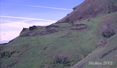
The 3 Bench Loop is a good hike for viewing early to mid-spring wildflowers and viewing early spring migrant bird species. Due to the steep slopes, poison oak, exposure to wind and sun, rattlesnakes and rocky slopes, it is not a hike for the faint of heart. The hike gets its name from the 3 benches cut in the hillside by the prehistoric Missoula Floods. The second bench may be viewed in the photo above. Wildflowers which may be viewed near the highway include all three desert stars, narrow-leaf skullcap, northwest balsamroot, puccoon and upland larkspur. Upon climbing the cliffs, the ground is literally covered with weak-stem Cryptantha, common Cryptantha, slender popcorn flower, and rusty popcorn flower. Wildflowers along the benches include poet's shooting star and possibly Cusick's shooting star, yellow bells, and several of the desert parsleys (including the following: nine-leaf d.p., slender-fruited d. p., pungent d. p., fern-leaf d. p., and the striking Columbia d.p..).
I would recommend that hikers not familiar with the area should not hike this area. The western portion of the loop that descends back to SR 14 is now signed as "No Trespassing" and that means not crossing the fence there. The same applies on the hillsides about 300 meters east of the parking lot which are likewise signed. Once off the highway, the area is open range with no fences and it becomes too easy to wander out of the area of public ownership, and the surrounding landowner and his rangehands are not friendly to trespassers. I believe that a good mapping gps shows the park boundaries, and one should stay well within the boundaries to be safe, and from previous experience, you still may not be safe from being hassled by the rancher.
For those familiar with public routes in this area, be sure to stay on the established trail, which is currently disappearing. Much of the land on both sides of the trail is in private ownership! Unfortunately, Russ Jolley who pioneered the route and cleared the route each year is no longer able to do so. Thus the route may not be as clear as it was in the past.
From Bingen, WA, proceed east on Washington State Highway (SR 14) through Lyle, WA. Continue east 2 miles along SR 14 to Doug's Beach where you park. Be aware that parking will be limited on windy days from spring through fall as this is a popular place to windsurf!
East Approach to Trail:
Hike east along the highway 0.2 miles to a concrete culvert that crosses beneath the highway. A dry stream bed runs eastward up the slope, parallel to the highway at this point. A steep path climbs about 25 feet up the bank, then climbs gently up the grassy slope to the northeast towards the cliffs. The beginning and end of the hike are not signed! The path soon cuts back to the northwest and begins a very steep ascent of a talus and cliff area. After several hundred yards, the path reaches the first bench where it becomes much flatter. The vernally moist stream can be seen again about 50 meters east. I would recommend not crossing the stream to head east as the railroad and a private land owner who do not like trespassers own those parcels of land.
Proceed west along the narrow and lightly tread path. You eventually come to ravine which carries some water in early spring or after rainfall. This is a good spot to search (carefully due to the steep slopes) for riparian plants and due to the tree cover, a good spot to look for migrating warblers, sparrows, lesser goldfinches and great horned owls. Proceed through the ravine and up the next rise to a higher bench with a large oak tree. This is a good spot for a rest or a picnic.
The game trail continues west at roughly the same elevation for another half mile or so but I would recommend not proceeding westward (past this large oak) as private land is soon reached again, and there are no signs up here to warn of trespassing.
Turn around and proceed back to your car the same way you came, or proceed cross country to the east a different way since this is open countryside.
West Approach to Trail:
Because the land uphill immediately to the west of the parking area is private (it should be signed "No Trespassing"), the western approach should not be attempted. There is a way down from above this is on public land but it passes very close to the private land so it should not be attempted because there is no established trail there to prevent people from wandering westward to places they should not be.
February 15, 2010: Slopes above Dougs Beach (several miles or so east of Lyle, WA)
February 26, 2005: Lower slopes
February 18, 2002: Tom McCall Nature Preserve, The Dalles Dam, The Dalles Mountain, Three Bench Loop, & Catherine Creek.
February 2, 2002: Tom Mc Call Nature Preserve, Three Bench Loop, & Catherine Creek