Lowest Elevation: 4200'
Highest Elevation: 5800'
Elevation Gain: 1600'
Trail Length: 4.1 miles (6.6 km)
Permits: Northwest Forest Passes should be displayed on your dashboard or on the mirror at all Forest Service Trailheads for access to Mt. Adams. All who hike above 7000' should obtain and display the Cascade Volcanoes Pass and register for and carry the wilderness permit. Climbers above 7000' should also register at the Forest Service Ranger Station at Trout Lake.
Water: This hike has only one water source, a small creek above the midpoint. As I've only done this hike early in the season, I'm not how persistent the water is late into the season. As with all water on the mountain, filter, boil or chemically treat it for safe consumption.
The trailhead provides several picnic tables and places for tents or small trailers as well as hitching posts for horses. No restrooms or water is available at the trailhead. Springs should along the main access road should fairly dependably provide water.
The trailhead is in a clearcut at 4193' elevation. The trail ascends into the woods, then joins an old logging road after about 100 meters and turns right uphill. The road winds uphill through forest then into another clearcut for another quarter mile or so before entering the forest and passing the wilderness boundary.
The trail then follows the ridgetop for about one and one-half miles before briefly coming into several small, grassy meadows. At this point, the trail switchbacks west and descends the west-facing slopes of the ridge, descending sharply at times before the tread levels out and the trail again turns north towards the mountain, crossing a small, intermittent (?) stream. The trail now climbs again, traversing several dry, open areas before entering forest again. A large, level meadow is soon reached with nice views of the southern slopes of the whole mountain. The meadow contains a number of wildflower species not seen below. The meadow is perhaps 200 meters long and the trail again enters forest and continues its climb, After climbing more sharply again, the Pacific Crest Trail #2000 is reached near an altitude of 5800'. Turn left to proceed downhill several miles to a large parking area just east of Road #23. Turn right and continue uphill to a junction with the Round the Mt. Trail # 9 at Horseshoe Meadow (~5900').
With constant hiking, expect to cover the length of the trail one way in about 2 or more hours.
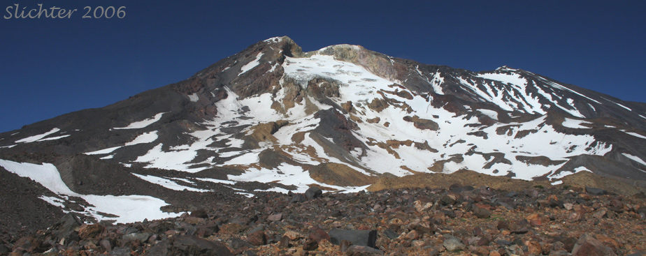
a) Horseshoe Meadows (See photo below.): This meadow is fairly dry and affords good, open photographic views of the southwestern slopes of Mt. Adams. Because of its dryness, it does not offer an abundance of colorful flowers to photograph with the mountain behind it. However, if one walks cross country upslope, following Cascade Creek at the eastern edge of the meadows, one will encounter smaller meadows which might have an abundance of photographic flower patches with the mountain in view behind it. Most years these meadows would be near peak for photographing by the first or second weekend of August. I'm speculating about this as I've only visited the slopes above Horseshoe Meadows twice, in late July 2006 (a fairly high snow year) when the bloom was just beginning to commence and September 2008 (another high snow year).
b) East facing dry meadows just below and east of the Stagman Ridge Trail about one hour above the trailhead. These are visible on the Forest Service maps at a point where the trail turns abruptly west and begins to descend to a small creek to the west of the ridge. This area makes a nice lunch spot and contains plant species more common on the east side of the mountain (like Steershead: Dicentra uniflora). I'm assuming there are views down into Cascade Creek and over towards Crofton Ridge.
c) A number of folks leave cars at both the Stagman Ridge and Shorthorn Trail trailheads and hike up one trail to the Round the Mt. Trail #9 then down the other trail for a long day trip. This offers a chance for numerous views of the mountain, botanizing and good birding (the earlier in the season the better as the birds will be more vocal and more likely to be called out for easier viewing).
d) One can also do a long day trip starting on the Stagman Ridge Trail, then join the Pacific Crest Trail past Horseshoe Meadows, then proceed north towards the Divide Creek Trail. The Adams Glacier will increasingly become more spectacular as you walk north. Proceed as far north as you are comfortable with and return the same way. North of Horseshoe Meadows there is very little running water (especially in late summer and fall) so bring water with you, or fill your water bottle at Cascade Creek at the east end of Horseshoe Meadows. On most week days, this will be a trip where you see only a few people.
August 9, 2021: Stagman Ridge Trail #12 and the Pacific Crest Trail to Horseshoe Meadows (Mt. Adams Wilderness)
September 13, 2008: Upper Cascade Creek Basin (Horseshoe Meadows to higher than the Bumper)
June 2, 2007: Stagman Ridge Trail #12 (from trailhead to Mt. Adams Wilderness boundary)
July 27, 2006: Horseshoe Meadows & slopes above it to 7000'
July 27, 2006: Stagman Ridge Trail #12
July 27, 2006: Stagman Ridge Trail #12 Trailhead