Permits: Northwest Forest Passes should be displayed on your dashboard or on the mirror at all Forest Service Trailheads for access to this trail. All who hike above 7000' should obtain and display the Cascade Volcanoes Pass and register for and carry the wilderness permit. As noted below, sections of the trail that are in the Yakama Reservation need separate permits obtained from the Yakamas.
Water: Filter or boil all water along this route! Gotchen Creek at the forest boundary/ Yakama Reservation (flows all hiking season), Morrison Creek which is just west of Trail #183 (flows until mid- to late summer), Crofton Creek which is just east of Trail #16, the mineral laden waters of the branches Salt Creek which is just west of Trail #16 (look for a good-size stream gushing all year long from the ground immediately below (south) the trail, Looking Glass Lake, or the various branches of Cascade Creek (available through mid-summer, one of which is foul-smelling with sulfur!).
High Elevation Point: 6400'
Low Elevation Point: 6000'
Length: From Trail #183 to Trail #2000, the Round the Mt. Trail #9 extends about 6.1 miles.
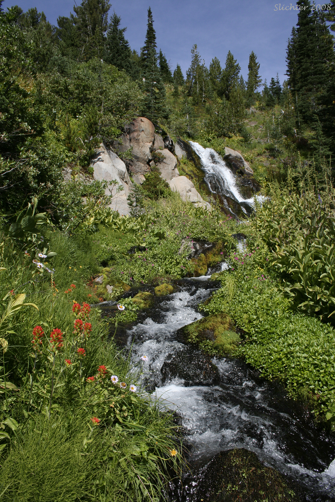
The Round the Mt. Trail begins on the east at the Bird Creek Meadows parking lot on Road #8290.285. Permits for hiking, camping and parking in the reservation are needed for this section and available from rangers stationed at Mirror Lake or Bird Lake. The trail can also be accessed via trail from Bird Lake. The trail climbs slowly along an old roadbed (I'm assuming people could drive to what is now the Bird Creek Meadows Picnic Area when it was originally under forest service control until the 1960s before leveling off. The Bird Creek Meadows area provides numerous creeks which cross the trail and provide numerous places to photograph wildflowers alongside the streams and waterfalls. There are however, not many spots where one gets a good view of Mt. Adams from this section of the trail. At about 2 miles, the trail reaches the boundary between the reservation and the national forest.
The Snipes Mt. Trail #11 joins the trail at this point, and Gotchen Creek crosses here as well (the last spot with reliable water late into the year for many miles). The trail continues westward, climbing slightly as it crosses the upper portions of the Aiken Lava Flow. From here, there are open views to the south across the lava flow towards Snipes Mt. and King Mt. If one is patient, this is a good place to view pikas and is at the southernmost extension of the range for the hoary marmot. The trail continues westward, climbing and descending gently for about another mile to its junction with the South Climb Trail #183. The open areas at this junction provide great views of the south face of Mt. Adams. Late in the season, one can make out the old summit cabin (with binoculars).
West of Trail #183, the trail enters open coniferous forest and descends slightly. Within a mile, it crosses several small tributaries of Morrison Creek which feature nice camping spots, although the water disappears by mid to late August most years. Slightly further, the trail features nice views out across the Morrison Creek basin to Crofton Ridge and south towards Trout Lake and even Mt. Hood on the horizon. Immediately before the junction with the Shorthorn Trail #16, one must cross Crofton Creek, which might be a challenge due to fast, high water early in the season. Just beyond this latter junction, the Round the Mt. Trail affords good views both up the Salt Creek drainage towards the terminal moraines at the base of the Avalanche Glacier, and south into the basin of Salt Creek and Cascade Creek.
Immediately before arriving at Madcat Meadows (where I believe a fair number of people camp), one arrives at a steep cross slope with cliffs above the trail. This slope affords a number of different plant species that are rarely seen on the mountain, including the yellow penstemon, Penstemon confertus. About 2.2 miles west of the Shorthorn Trail, one arrives at the Trail #9A which descends steeply about 0.9 miles to Looking Glass Lake, another popular destination with hikers along this trail. Continuing west of Trail #9A for about 1.1 miles, you eventually arrive at the junction with the Pacific Crest Trail #2000 at Horshoe Meadows, where a number of hikers camp and where there are excellent views up towards the mountain.
Note:
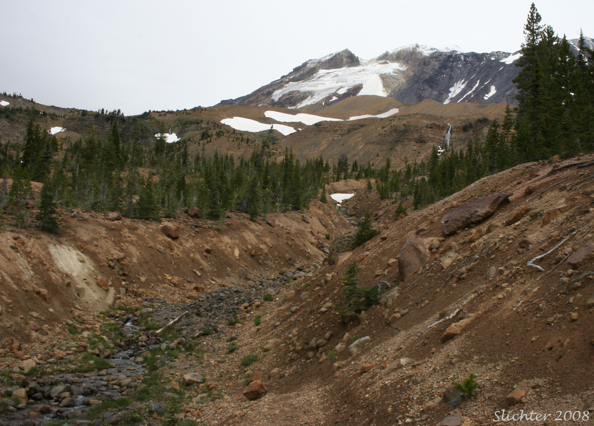
The heavy rains of November 2006 caused water to pool in the glaciers and when they reached high amounts, they caused a large glacial outburst of water which flowed down into the Crofton & Morrison Creek drainages as well as into the Cascade Creek and Salt Creek drainages. These flash floods scoured the upper creek beds so savagely that hikers were presented with near impossible creek crossings. Due to the erosion, the trails end at the edges of each of these creeks with a shear drop of 10-20 feet. The earliest 2007 hikers had to rope up to get through these obstacles. Temporary trails into these scoured drainages have been made, but it is unclear whether the Forest Service will affect more permanent repairs.
September 5, 2008: Round the Mt. Trail #9 (South Climb Trail #183 to Madcat Meadow)
July 27, 2006: Horseshoe Meadows & slopes above it to 7000'
July 29, 2005: Shorthorn Trail & Round the Mountain Trail #9 (from Morrison Creek Camp to Madcat Meadows)
September 12, 1998: Round the Mountain Trail #9, from Cold Springs C.G. to Bird Creek Meadows and Hell Roaring Overlook, Mt. Adams Wilderness & Yakama Nation.