Wildflower Hiking the Muddy Meadows Trail #13
Mount Adams Wilderness
From Trout Lake:
Drive north from Trout Lake on Road #23 (sometimes known as the Mt. Adams Recreational Access Rd) for 25.6 miles to the junction with paved road #2329. Proceed right onto Road #2329 and follow it 7.8 miles to Road #087 on the right side of the road. Turn right (east) onto Rd #087 and drive 0.4 miles to the trailhead.
From Seattle, Tacoma, Yakima and Portland:
From Randle (on US Highway 12) proceed south for 0.9 miles on State Road 131 (sometimes signed as Forest Road 25). Turn left onto Road #23 and follow it uphill to the junction with Road #2329 where you will turn left and drive for 7.8 miles to a junction with Road #087. Turn right and drive 0.4 miles to the trailhead. Note: It's wise to check the Gifford Pinchot NF website or call the Cowlitz Valley Ranger District Office in Randle, WA for the latest road conditions. There have been occasions where FS Road #23 has been closed in recent years due to flood damage.
Lowest Elevation: 4400'
Highest Elevation: 5800'
Elevation Gain: 1400'
Length of Trail: 4.0 miles (6.4 km) one way. This equates to 2.5-3 hours of hiking at fairly constant speed.
Permits: Display Northwest Forest Pass on the dashboard or mirror of your vehicle parked at the trailhead. Register and carry your wilderness permit with you. If you plan on climbing the mountain, or have hiking plans above 7000', register the specifics of your route at the Mt. Adams Ranger Station and purchase a Cascades Volcano Pass.
Trail Use: Generally light, even on weekends. However, a fair amount of horse traffic travels this trail as part of a loop with the Highline Trail #114 and either the Killen Creek Trail #113 or the Divide Camp Trail #112.
Water: Filter or treat all water along this route. Several ponds may be found on the east side of the trail near the first mile mark. In addition, you will pass 2 small streams and one seep as the trail begins to climb below 4700'. There will not be water again until you have proceeded about 1.5 miles past the Pacific Crest Trail where a small stream is found at an informal forest camp.
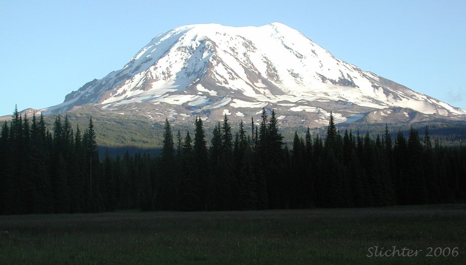
Beyond the trailhead, the trail is most useful as an access point either for the Pacific Crest Trail #2000 so that one may then hike into Killen Creek Meadows or the Highline Trail #114 with its access to either Foggy Flats, the Devils Gardens, or Avalanche Valley on the Yakama Reservation. The trail is largely in forest and lacks good clear views of either Mt. Adams, Mt. Rainier, or the Goat Rocks. However, it does offer the photographer interesting views of narrow meadows surrounding the trail that are lined with dense stands of lupine, cat's-ear mariposa lily, arnica and other wildflower species which might be attractive if the lighting is good.
Beginning at the trailhead, proceed southeast in a deep track which is at first in dry meadow, then in deep coniferous forest with some glimpses of meadow to the west and south. The trail is flat for the first mile or so and you wil turn south and cross a wet, muddy meadow on a wooden bridge. Shortly after this, you will pass a small pond about 50 meters to the east of the trail partially hidden by trees and brush. The trail begins to climb slightly, crosses a second bridge, and then you climb several steep stairs or water bars in the trail. These might be quite muddy early in the season, especially if horses have passed through before you. A small stream crosses under the trail at a third bridge, and the trail then begins to climb at a steeper rate. The trail now climbs about 600' via 4 very long switchbacks, then straightens out and climbs more slowly to the east before reaching the Pacific Crest Trail at slightly above 5200'.
Upon reaching the Pacific Crest Trail, hikers can choose to proceed right (south) along that trail for 2 miles to reach Killen Creek or continue another 2 miles along the Muddy Meadows Trail before reaching the junction with the Highline Trail #114. If choosing the latter trail, the trail continues east for about one-half mile, sometimes level and sometimes climbing slowly. The trail then turns south and begins climbing more steadily, although never steeply through narrow meadows filled with lupines, violets, arnica, pink heather and paintbrush. Occasionally, the upper portions of Mt. Adams can be glimpsed through the trees ahead. Fairly soon, a creek will be heard to the left, and eventually will be glimpsed at an unofficial campsite referred to as the Green Timber Camp. The stream above the camp is especially attractive early in the season as it is densely lined with the attractive pinkish-white flowers of Claytonia cordifolia.
After leaving the Green Timber Camp, the trail swings slightly southwest away from the creek, passing several moist swales and rocky outcrops draped in pink heather before reaching the Highline Trail #114 in about one-half mile. From this junction, turn left to head to Foggy Flats, a large flat meadow with the upper slopes of Mt. Adams visible in the background (and a good picnic spot), or continue steeply uphill on the main trail for another half-mile to timberline, where the views to Mt. Adams and Red Butte will be more sweeping. The alternative is to turn right or west on the Highline Trail and proceed 2.2 miles to the Pacific Crest Trail at Killen Creek, and then turn right again on the PCT to descend 2.0 miles back to the Muddy Meadows Trail for a loop.
August 28, 2012: Muddy Meadows
August 6, 2005: Road #2329 (TakhTakh Meadows Trail and Muddy Meadows)
June 21, 2005: Muddy Meadows