Private Lands and Malheur National Forest
Summit Prairie (approximately 5300') is a moderately large, relatively flat valley of mostly wetland habitat located to the southeast of the Strawberry Mountain Range in central Oregon. The periphery is largely Malheur National Forest although there is a mix of private lands and public lands in the center, with the public mostly at the southeastern end while the northern section is mostly private. Watch for signs denoting no trespassing, and if in doubt, please don't venture onto the land. All of the prairie here, both private and public is grazed at least several times through the season (with cattle moved to a new section of Summit Prairie after a week to help cut down on over grazing).
Summit Creeks runs north to south through the northern part of the prairie before crossing under the junction of FS Rd #16 and County Rd #62 where it then winds southwest through moist meadows before descending towards Logan Valley. Since the valley is largely flat, this creates extensive wetlands that are separated by several low, narrow ridges of shallow soil which support arid scabland habitats. Slightly higher ridges towards the periphery of the valley support open conferous forests of ponderosa pine and douglas fir.
Care should be taken to not venture out onto private or tribal lands in Summit Prairie. There is a turnoff and parking area t on the north side of FS Rd 16 just west of the junction with County Road #62. Use spotting scopes or binoculars to search the surrounding wetlands for birds and larger mammals. The site is a safe place to park off the main road and can be a base for short hikes along the main road in search of many of the more than 200 plant species that can be seen from the road.
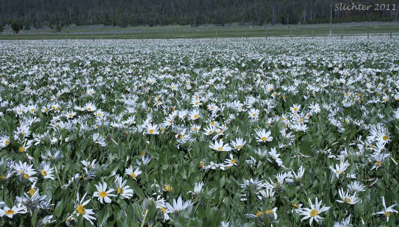
Summit Prairie is largely a moist wetland meadow in spring but begins to dry out by early July most years. The wetland portions are covered at most with several inches to perhaps as much as one and one-half feet of water in spring. Look for patches of magenta elephant heads (Pedicularis groenlandica), Cusick's paintbrush (Castilleja cusickii), common camas (Camassia quamash) with Blue Mt. penstemon (Penstemon attenuatus var. palustris), Oregon saxifrage (Saxifraga oregana), american bistort (Bistorta bistortoides) and several species of bright orange arnicas mixed in. Numerous species of sedges and rushes can be observed between the more showy flowers. Along the main roads near the periphery of the prairie, look for showy bigpod Mariposa lily (Calochortus eurycarpus), Cusick's elkweed (Frasera columbiana var. cusickii), neglected balsamroot (Balsamorhiza hookeri var. neglecta, northern mule's ears (Wyethia amplexicaulis), scarlet gilia (Ipomopsis aggregata), showy penstemon (Penstemon speciosus), sugar bowls (Clematis hirsutissima) and a vast patch of white-headed Wyethia (Wyethia helianthoides) in the central prairie in mid- to late June.
Watch for several herds of pronghorn antelope in the valley. Rocky Mt. elk and mule deer are also numerous, especially near the forest edges. Listen for the raucous cries of nesting greater sandhill cranes. Numerous birds of coniferous forest, riparian shrubland and wetland meadows should also be seen.
Much of the flora and wildlife can be observed from the car by driving FS Rd 16. Be aware that lands in the center of and north end of the prairie are largely private. If worried about getting wet while walking, my recommendation is to park at the pullout mentioned above and explore along the road edge where most plants can be seen easily. Evidently there is an old trail that leaves from the southwest corner of Summit Prairie then climbs uphill and wanders through the forest just north of FS Rd 16 for about 4 miles west before reaching the eastern edge of Logan Valley. This is marked on the map but I'm guessing this hasn't been maintained for a while, and it is not signed from the Summit Prairie end.
From John Day, drive south on US Highway 395 for about 10 miles and turn left onto Grant County Rd 65. Follow paved County Rd 65 (which becomes FS Rd 15 at the forest boundary) for about 15 miles before turning left onto FS Rd 16. County Rd 65 can be a bit windy so slow down and drive at an appropriate speed. Drive east on FS Rd 16 for another 4.5 miles to the west edge of Logan Valley. Logan Valley is about a 45-50 minute drive from John Day, OR. It is about a 25 minute drive east of Seneca, OR. Generally the road here has light traffic (except for free range cattle and the occasional deer, feral horse, or elk), although traffic is heavier on summer holiday weekends and during hunting season. Continue driving straight east across Logan Valley. The road proceeds uphill into the conifer forest at the eastern end of the valley and winds across a wooded ridge approximately another 4 miles east to Summit Prairie.
Summit Prairie can also be accessed from the north via Prairie City. From Prairie City, OR, drive south on paved Grant County Road 62 for about 40-45 minutes until reaching Summit Prairie.
The road is paved the entire way but ascends fairly steeply and winds a bit in places, so reduce your speed to stay on the road. There may be some logging and other truck traffic along the road early in the season.There are accomodations for larger groups at Lake Creek Camp on FS Rd 924 in nearby central Logan Valley.
Additional camping in nearby Logan Valley:
Just north of Lake Creek Camp at the junction of FS Rd 924 and FS Rd 1648 is Murray Campground which has 6 campsites and vault toilets.
Big Creek Campground is located along Big Creek about one-third of a mile north of FS Rd 16 in Logan Valley. There are 14 campsites, a pair of centrally located vault toilets and a manual water pump. The camp is fairly heavily used by ATV campers during the week before and after Memorial Day, the Fourth of July and Labor Day. Generally there are at least a few campsites open during the week. It also provides easy access to fly fishing in Big Creek. This is a fee site.
I should point out that I use Big Creek Campground (along with the North Fork Malheur CG further along FS Road #16 to the east) when I visit the area. The other campers have always been friendly, it offers easy access to the wildflower meadows to the west, and is an excellent place for morning and evening birding!
Partial Flora for Summit Prairie
August 20, 2011: Summit Prairie (Private lands and Malheur National Forest)
August 2, 2011: Summit Prairie (Private lands and Malheur National Forest)
June 25, 2011: Summit Prairie highlights - A Native Plant Society of Oregon Field Trip