Wildflower Hiking to McCord Creek & Elowah Falls
John B. Yeon State Park
 -
- 
 The photo at right shows Upper McCord Creek Falls from the cliffside trail..........spring 2005.
 -
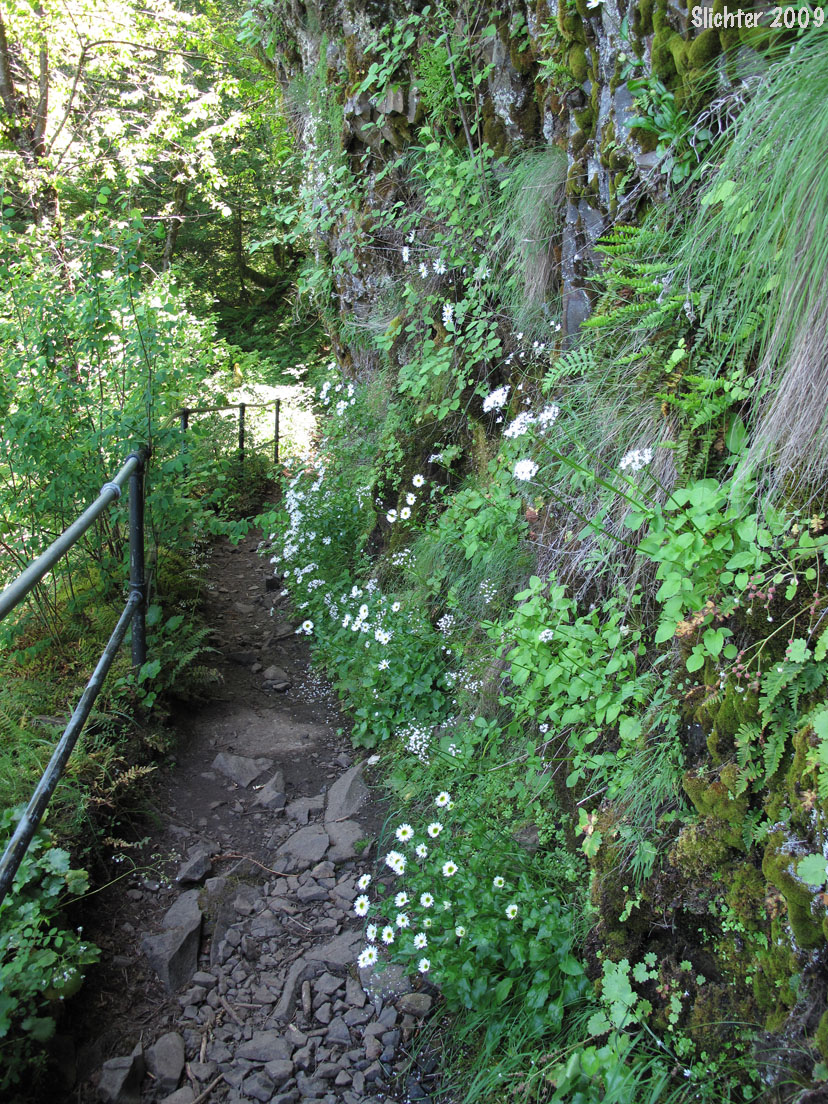
The photo at right shows Upper McCord Creek Falls from the cliffside trail..........spring 2005. Note: The upper trail is narrow with a sheer vertical cliff with a several hundred foot drop below the trail. There are also breaks in the guard rail and a few narrow spots in the trail due to erosion. Be safe here! In addition, one of the switchbacks that drops down towards Elowah Falls on the lower trail has partially given way and the logs helping hold the trail in place have slid across the trail. Take care here too!
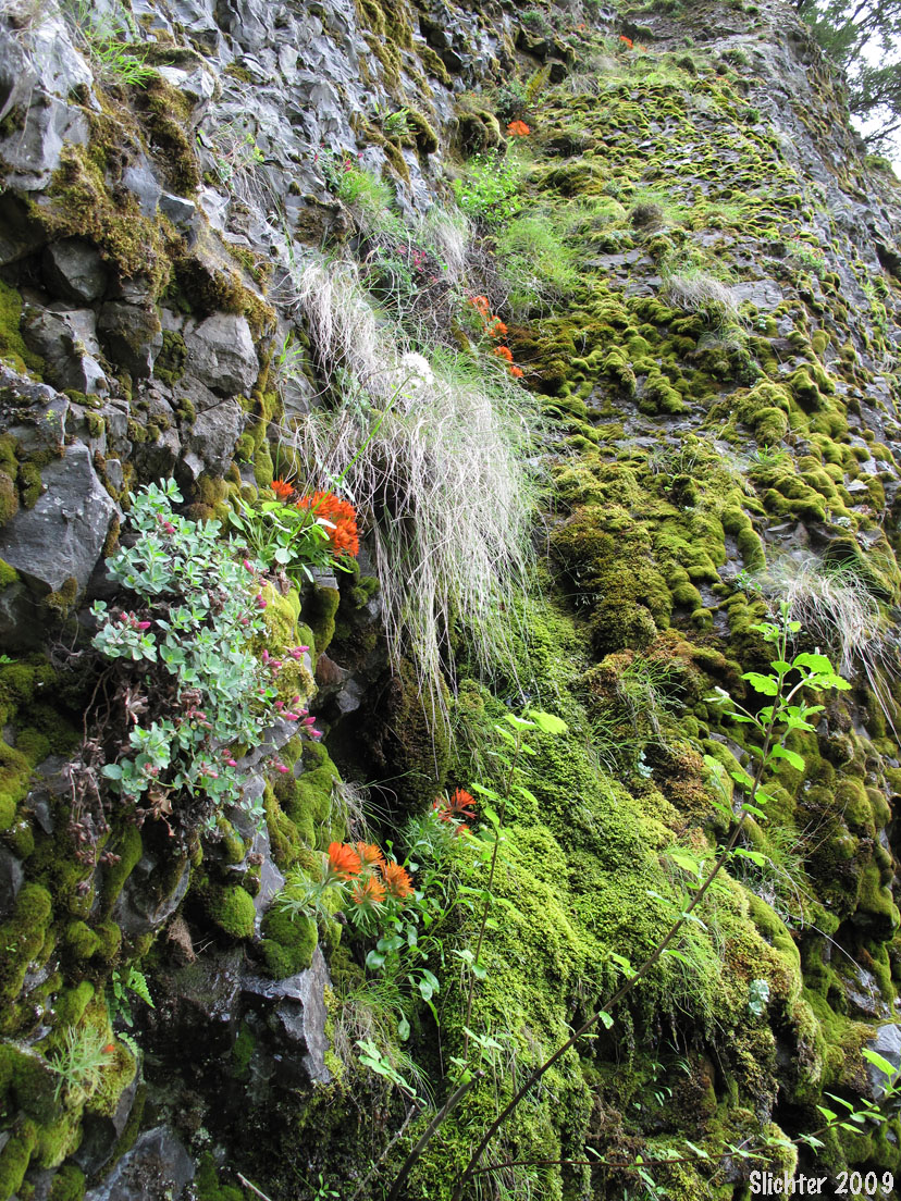
The trail to McCord Creek and Elowah Falls has long been one of my favorite hikes. Its close proximity to Portland means that I can leave work on the lengthening spring days and be on the trail within 30 minutes. The hikes offer a variety of plant habitats, ranging from deciduous forest to riparian below, and drier and often hanging rock gardens above. As the first sour cherry trees blossom in the spring, multitudes of warblers and hummingbirds begin darting through the branches in search of newly emerged insects or nectar. Chipmunks frolic through the underbrush as winter wrens and pikas sing on the steep slopes. During some recent years, osprey have been observed nesting on tree tops below the cliff top trail. In addition, many species of mosses are abundant and within easy viewing of the trail, and liverworts may be seen in moist drip areas near the upper falls.
Upon arriving at the trailhead, pack valuables in the trunk. One can frequently see broken auto glass at this site. It is constantly checked by the local sheriff deputies as well as the Oregon State Patrol, but they can't be everywhere at once. As of this writing, I don't believe a trailhead parking permit is needed.
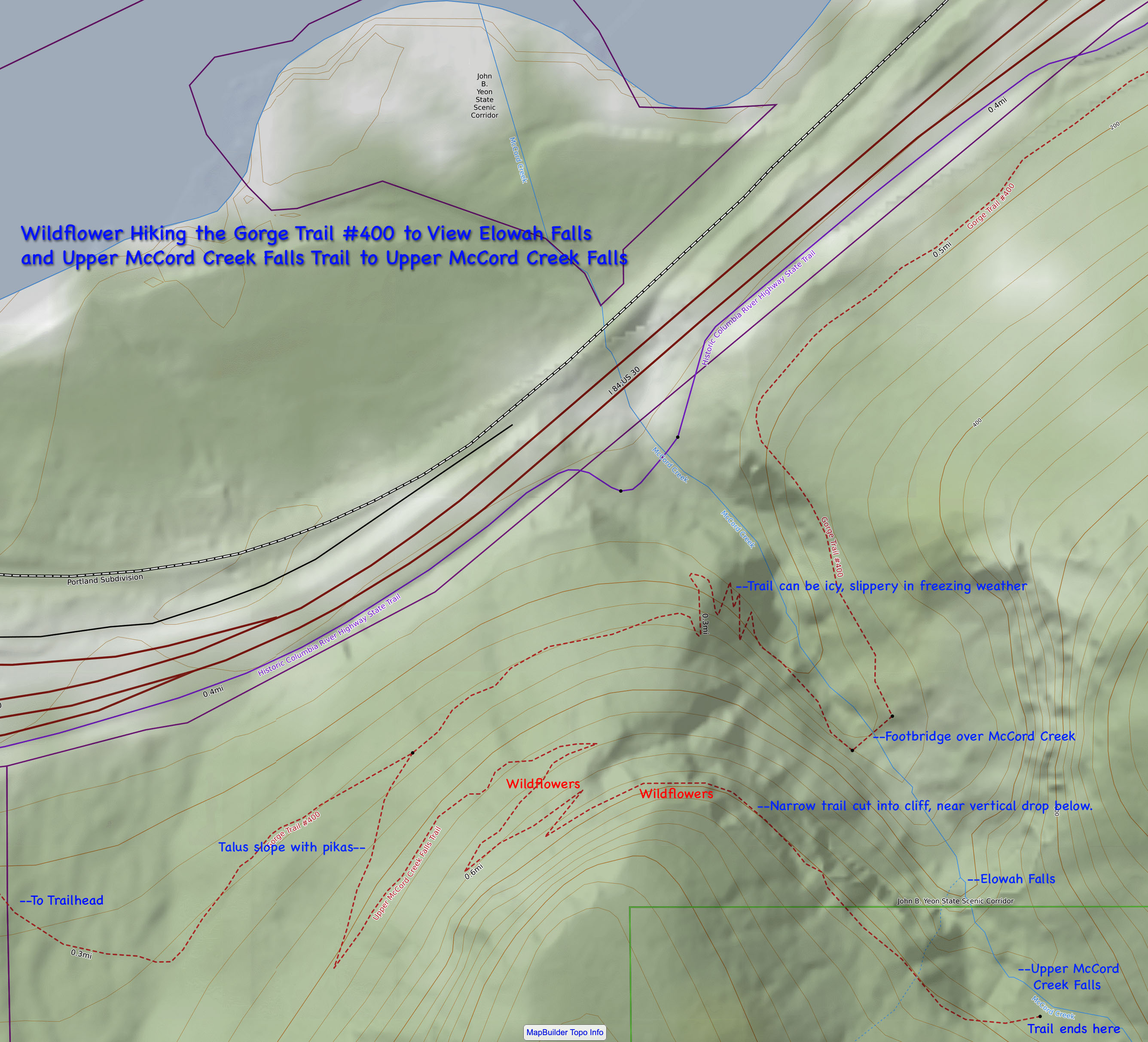
Upon exiting one's vehicle, proceed to the west end of the parking lot to the trailhead. Proceed up the trail past the old water tank, curving east on fairly level ground. Another trailhead for the Gorge trail is quickly reached. This segment heads west towards Ainsworth and eventually climbs into steep slopes beneath the cliffs. Probably most noteworthy is the damage done to these slopes by erosion, the result of flash floods during the past few winters. Some of these floods have nearly covered Interstate 84 with debris, and the old farmhouse seen upslope near the Ainsworth exit from I-84 was buried to the 2nd level by a flood several years ago.
Continuing east on the McCord Creek trail, one begins to climb through patches of deciduous and coniferous forest within a quarter mile. Many members of the lily family may be seen here along the trail in early to mid spring. At the top of the first significant rise, one has a choice of two trails to take. The lower trail which proceeds straight ahead and at a fairly level pace proceeds to the lower creek, which may be crossed by bridge (except after high flood years). Scouler's heliotrope may be seen in spring upon descending to the creek and Sitka Mist Maidens are visible on the rocky areas immediately around the bridge.
The upper trail climbs steadily amid numerous switchbacks to the base of the cliffs where a trail has been carved. A rickety railing of old pipes provides some insurance, but for those with fear of heights, the shear cliffs which drop below parts of the trail may prove too much. In spring, water constantly drips off the cliffs, and small rocks may also fall on the trail. Cliff paintbrush and white shooting stars may be seen along the trail, and one may see hanging gardens of Douglasia above in early April. The latter flowers are a stunning pink and are best viewed with binoculars. Look for them too on the faces of the cliffs on the east side of the creek. Cutleaf Penstemons, Oregon sunshine, and long-beard hawkweed may be viewed along the trail during the summer.
The trail along the cliff is level and has good views across the Columbia River towards Beacon Rock as well as the lower and upper Elowah Falls. Within a quarter mile, the trail reaches the creek, just above the lip of the upper falls. This is a popular picnic spot, and during the hot summer months a heavily visited spot for hikers to soak their feet. It is possible to walk a distance up the creek from the falls during low water in the summer, but the rocks are slippery and once must be very careful! The elevation gain to the upper falls is approximately 340 feet.
Note: As of 2016, the trailhead for John Yeon State Park can be full by 9am most days during the height of the hiking season, although hikers have a choice of a number of trails from this trailhead. Due to its close proximity to the freeway, the trailhead has also seen an increase of car cloutings. Take all items with you when you hike from this trailhead.
 East Bound Directions:
For drivers eastbound on Interstate 84, take the Ainsworth Exit (Exit 35) onto the Columbia Gorge Scenic Highway. At the end of the exit, turn left following the signs towards Dodson and Warrendale. After about 150 feet, take the right turn onto Frontage Road which parallels the freeway. Do not reenter the freeway at this point! The house which was partially submerged by debris from a previous flashflood will be visible several hundred yards upslope. Continue along Frontage road, paralleling the freeway for about 2.3 miles. Just before the road reenters the freeway at McCord Creek, turn right into the large parking area which is the trailhead for this hike. If you miss the Ainsworth Exit, you will need to continue to the Tanner Creek, Bonneville Fish Hatchery exit and return west.
Westbound Directions:
For drivers westbound on Interstate 84, take the Dodson-Warrendale Exit (Exit 37). Take the first left and pass under the freeway and take the left onto Frontage Road (the old scenic highway). Proceed east about four-tenths of a mile to the Parking area on the right side of the road (just before the entrance to the freeway). If you miss Exit 37, take the Ainsworth Exit (Exit 35) and proceed via the eastbound directions.
Fairly Comprehensive Plant List for Trails to Elowah and Upper McCord Creek Falls
McCord Creeek/ Elowah Falls: Northwest Wildflowers
John B Yeon Trailhead: OregonHikers.org
Elowah and Upper McCord Creek Falls: Washington Trails Association
Upper McCord Creek Falls: Friends of the Columbia Gorge
Elowah Falls: Friends of the Columbia Gorge
Upper McCord Creek Falls Hike: OregonHikers.org