The Monte Carlo-Monte Cristo ridgeline is a low chain of mountains that runs around the eastern and northern rim of the Little White Salmon River drainage on the east slope of the southern Washington Cascades. The long, forested ridge is quite prominent on the western skyline when driving along Washington Highway SR 141 up the White SalmonValley as well as from the north when viewed from Trout Lake, WA. The ridgetop provides both dry grass meadows and rock gardens, home to numerous wildflowers found further east. The steep slopes are now largely forested with conifers with a mix of maples and other deciduous shrubs as an understory. Much of the area was burned early in the 1900s though some stands of older conifers survived and are now approaching old growth status. The wildfire last century opened up the forest so that there were great views east and west from the Monte Carlo and Monte Cristo ridgelines but maturing trees are now blocking most of those views. A fire lookout was located atop Monte Cristo at one point but was removed in the 1950s.
Several trails climb to the summit ridge from all directions, and the Monte Carlo Trail #52 and Monte Cristo Trail #53 run north to south along the ridgetop. All are lightly travelled so the area is a welcome hiking spot for those wishing to get away from the crowds. Note that the trails coming uphill from the bottom of the Little White Salmon River valley are long with a lot of elevation gain so they see very little use, and the trails may not always be maintained, at least through early summer. It doesn't hurt to check with the Gifford Pinchot NF ranger station in Trout Lake to discover what the trail and road conditions are.
The draw for wildflower hikers is the mix of older forest with the grasslands and rock gardens on the open ridgetops. Especially attractive are the meadows of deltoid balamroot (Balsamorhiza deltoidea) and harsh paintbrush (Castilleja hispida). These seem to peak in bloom from early to mid-June most years and although they aren't quite as stunning as those to be found on Dog Mountain, the display is nicer than that to be seen atop Grassy Knoll.
 Directions:
North trailhead from Trout Lake, WA:
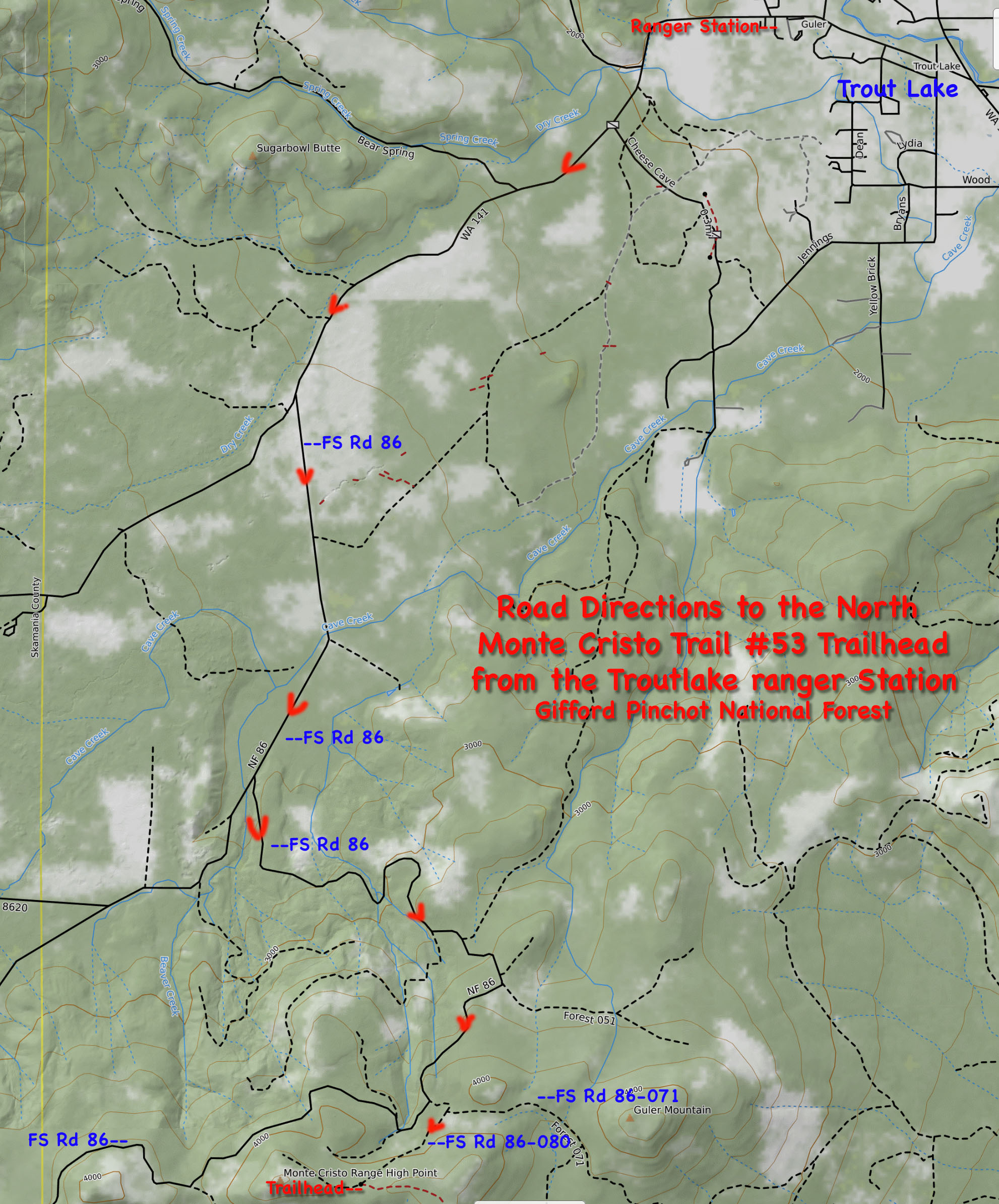
From the ranger station in western Trout Lake, WA, drive west about 3.2 miles on Washington Highway SR 141 (about 3.8 miles west of the gas station in downtown Trout Lake). Turn left (south) onto Forest Road 86 and drive about 1.9 miles to a Y- junction with FS Road 8620 which may be unsigned. Note that Google Maps accurately shows this junction and the road numbers when magnified. Stay left to keep on FS Rd 86 at this junction and begin climbing and switchbacking up the ridge. After approximately 2.8 miles, stay left onto FS Road 86-080 for less than a tenth of a mile before it curves sharply right at a junction with spur road 071 signed for Guler Mt. A weathered sign at this junction indicates the trailhead is another 0.5 mile ahead. The road becomes very rough and continues climbing up through forest. The trailhead which is on the left has a new sign as of 2022. However, during other years, there has been no sign and the only evidence of the trailhead has been red ribbons hanging from the branches. Find a place that is wide enough on the narrow road (either before or after the trailhead) to park. Do not block the road. There is a widespot about one-tenth of a mile uphill past the trailhead to turn around.
The Monte Cristo Trail #53 climbs the north slope of the Monte Cristo ridgeline through beautiful old growth forest before dropping down a fairly open slope to a draw. It then switchbacks up another open slope with nice wildflowers and a view north past Guler Mountain to Mount Adams. Continue south along the fairly level ridge top. The old lookout site is at the south end of the ridge before the trail begins steeply descending down into the saddle between Monte Carlo and Monte Cristo where the southern trailhead can be accessed.
South Trailheads:
From the stop light at the north end of the Hood River Bridge, drive west on Washington Highway SR 14 about 8.9 miles. Turn right onto the Cook-Underwood Road signed for Mill A and Willard. Drive uphill about 5.2 miles and turn left onto Willard Road. At 1.4 miles, after passing through the old logging community at Willard, turn left onto Oklahoma Road. Drive 7.9 miles to the Oklahoma Campground where the road changes to gravel and becomes Forest Road 18. Proceed another 0.2 miles through the campground and note a one vehicle pullout on the left to park with the Monte Carlo Trailhead on the right (east). This is the longer loop hike which involves climbing up to Monte Carlo then proceeding north along the ridgeline to Monte Cristo. There's a 2450' elevation difference between the campground and Monte Cristo. The OregonHiker.org link below for the loop trail gives a good account of this route.
An alternative with shorter access is to continue driving on Forest Road 18 north of Oklahoma Campground and stay right onto spur road 18-230 to the lower Monte Cristo #53 Trailhead. I've not been to this one, so it is prudent to call the Gifford Pinchot NF ranger station to see whether the access road is still open as some maps indicate the road is closed. Also check to see that the trail has been logged out in the spring. Note that there is at least a 2110' elevation gain along this lightly used section of trail.
A second alternative with even shorter access and much less climbing is to turn right from Forest Road 18 onto Forest Road 1840 about one mile before reaching Oklahoma Campground. FS Rd 1840 winds up the ridge to a saddle between Monte Carlo and Monte Cristo where there is another trailhead for the Monte Cristo Trail #53 as well as the Monte Carlo Trail #52. Likewise, check with the ranger station to check on road and trail conditions, especially early in the spring. Note that the elevation gain to Monte Cristo from this trailhead is about 1000' to the summit of Monte Cristo and about 900 to the high point on Monte Carlo.
 Plant Lists:
Comprehensive Plant List for Monte Cristo
May 24, 2025: Monte Cristo Trail #53from the Road 86-080 Trailhead (Gifford Pinchot National Forest)
June 21, 2022: Monte Cristo Range (Gifford Pinchot National Forest and Washington Department of Natural Resources lands)
June 18, 2021: Monte Cristo Trail #53 from the Road 86-080 Trailhead (Gifford Pinchot National Forest)
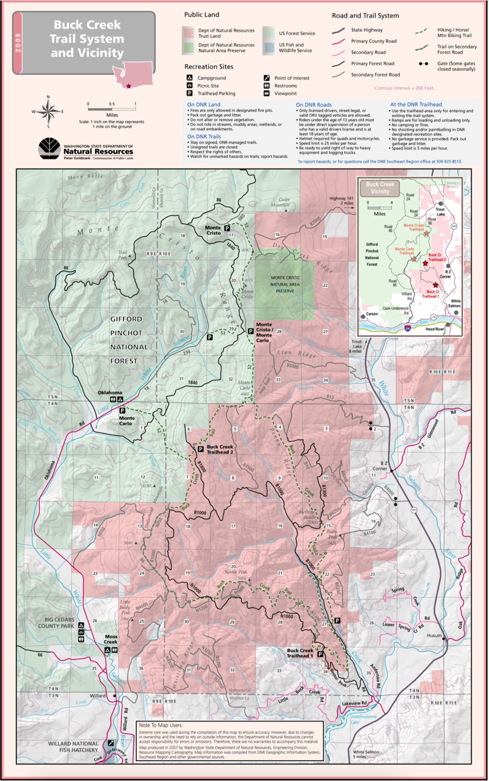
Buck Creek Trail System and Vicinity Map: Washington DNR - This is a good map to print off when planning to hike the trails of the Buck Creek Trail system as well as hiking Monte Carlo and Monte Cristo.
Monte Cristo Trailhead: OregonHikers.org - Directions to the trailhead accessed via the Little White Salmon drainage.
Monte Carlo-Monte Cristo Loop Hike: OregonHikers.org
Monte Cristo: Washington Trails Association - Provides directions to the north trailhead from Forest Road 86-080.
Monte Cristo Trail #53: Gifford Pinchot National Forest -Provides directions to both the north and south trailheads.
Report regarding a proposal to establish Monte Cristo as a research natural area (circa 1994). Part of the area has since become a DNR Natural Area Preserve.
In the photo at left, the Monte Cristo Trail #53 climbsfrom the northern trailhead through a beautiful old growth forest to the ridge top. Gifford Pinchot NF....June 18, 2021. The photo at right shows the Monte Cristo Trail #53 switchbacking up an open slope to get to the Monte Cristo ridgeline, Gifford Pinchot NF.....June 18, 2021.
The photo at left shows a rocky wildflower meadow along one of the ridgelines of Monte Cristo, Washington Department of Natural Resources lands.....June 21, 2022. In the photo at right, the view shows that as one climbs towards the top of the Monte Cristo ridgeline, there's a beautiful view north towards Mount Adams, Gifford Pinchot National Forest.....June 18, 2021.
The photo at left shows a ildflower meadows along the summit of the Monte Cristo ridgeline, Gifford Pinchot NF.....June 18, 2021. The photo at right shows a rocky wildflower meadows along the Monte Cristo ridgeline, Washington Department of Natural Resources lands.....June 21, 2022.
The photo at left shows a wildflower meadow along an open ridgetop, Washington Department of Natural Resources lands.....June 21, 2022. The photo at right shows wildflower meadows along an open ridgetop on Monte Cristo, Washington Department of Natural Resources lands.....June 21, 2022.