Wildflower Hiking the West and Northwest Sides of Mount Adams
Gifford Pinchot National Forest and Mount Adams Wilderness
[Alpine and Subalpine Wildflowers of the Cascade Mountains of Oregon and Washington] - [Places to See Wildflowers in the Gifford Pinchot National Forest]
[What's in Bloom Now in the High Cascade Mountains of Oregon and Washington?] - [Gifford Pinchot National Forest]
At the southwestern corner of the mountain, the round the mountain trail joins the Pacific Crest National Scenic Trail #2000 which extends northward along the western skirts of the mountain. Horseshoe Meadows can be found at this junction, and affords a nice base camp for exploration of this corner of the mountain. Please don't camp in the meadow here!
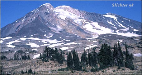
The Pacific Crest National Scenic Trail #2000 extends northward at this point. I find this part of the trail to be pretty remote. There are only several places where water can be found summer long in this area. Refill (and filter) your water bottles at Horseshoe Meadows. Campsites here might be somewhat limited along the trail, and several of the creek crossings could be challenging on hotter days due to glacial melt. Good campsites can be found where the trail crosses Riley Creek and at the north in the meadows below the Adams Glacier.
At the northwestern side of the mountain, one may take trails # 112 and #113 to reach the Pacific Crest Trail. Trail #112 leaves Road #2329 about one mile southeast of Takhlakh Lake, and climbs along the Middle Fork of Adams Creek. Trail #113 is a little longer, and departs from Road #2329 near Killen Creek Campground. The meadows at timberline where both of these trails meet the Pacific Crest Trail provide water (filter) and beatiful campsites. numerous wildflowers can be seen along all the trails and also in the meadows. Be careful exploring the upper slopes if you wish to look for alpine flowers that can be found on the moranes and on the rocky areas.
The Pacific Crest Trail proceeds upward and to the northeast from this region and crosses a ridge separating the Adams Glacier from the Lava Glacier. An old trail, #114 or sometims called the Highline Trail leads east from the Pacific Crest Trail around the north side of the mountain. This area is very remote, and you may wish to check the condition of the trail before trekking it, as it sometimes may not be cleared for several years at a time. In addition to a trail which may fade in and out and rugged terrain, this trail also must cross several streams which can be very dangerous to cross!
The alpine and subalpine regions of Mt. Adams are typically fairly snow covered until well into June. Peak bloom near timberline generally begins in mid- July, and extends until early September. The winter months find this region covered with several to many feet of snow.
From the South:
From Washington State Road 14 which parallels the Columbia River, turn north on the cutoff road to Highway 141 at the east side of the bridge spanning the White Salmon River. Follow Highway 141 north through Husum, WA and BZ Corners, WA to Trout Lake, WA. The ranger station is at the west end of the main road through town. To get to the soutwestern and northwestern sides of the mountain, the most direct route is to turn north (right) onto forest road 23 at the east end of Trout Lake. Several miles north, the road reaches the forest. Rd #23 turns northwest. Take this road. You can access the southwestern side of the mountain via the Pacific Crest Trail which begins on road #521, which is at the forested saddle just past the spectacular close views of the southwestern side of Mt. Adams.
Continue north on Road #23, passing the paved intersection with forest road #90. After passing forest road 335 which takes you to Council Lake Campground, proceed a half mile on Road 23, then turn onto road #2329 which will bring you to Takhlakh Lake and Killen Creek Campgrounds as well as the trailheads for Trails #112 and #113. These three campgrounds make good base camps for day excursions into the wilderness.
Access to Mt. Adams may also be attained from the west via Road #90 which runs to the south of Mount St. Helens National Monument. Check to make sure this road is open after heavy rains, as flooding has occasionally wiped out bridges along this route. This route gives more direct access to the northwest and southwest sides of the mountain, and is the only road that is paved most of the way to the mountain.
From the north, one may arrive at Mt. Adams by driving to Randle, WA (from Yakima in the east and Interstate 5 in the west) and turning south on Forest Road #23. This route gives more direct access to the northwest side of the mountain, especially if you are arriving from Puget Sound or Yakima.