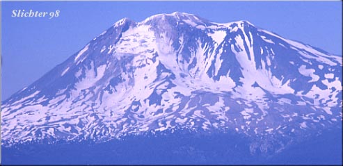
Wildflower Hikes on the South Side of Mount Adams
Gifford Pinchot National Forest and Mount Adams Wilderness
For current information on trail conditions, huckleberry picking times, truck traffic on roads, and other recreational information, contact the Gifford Pinchot National Forest.
At the southwestern corner of the mountain, the round the mountain trail joins the Pacific Crest National Scenic Trail #2000 which extends northward along the western skirts of the mountain. Horseshoe Meadows can be found at this junction, and affords a nice base camp for exploration of this corner of the mountain. Please don't camp in the meadow here!
The Round the Mountain Trail, Trail #9, extends east from Horsehoe Meadows, and runs eastward at roughly the same elevation, with a few ups and downs, to Bird Creek Meadows in the Yakima Indian Reservation at the southeastern corner of the mountain. This trail passes beneath the large moranes beneath the White Salmon and Avalanche Glaciers, sites of large landslides in 1921 and 1997. Trail #13 leaves the trail and treads south, and downhill to Lookinglass Lake about a mile east of Horseshoe Meadows. Madcat Meadows about one and one-half to two miles east of Horseshoe Meadows affords a decent camp and a chance to look for meadow wildflowers. Several of the creeks in this section of the mountain have salty walter, hence the name of Salt Creek. Further east, one will see several more meadows as well as interesting riparian areas as one proceeds to a saddle on Crofton Ridge. The ridge as it extends south also offers a few plants that like drier, rockier habitats. On the eastern side of the saddle at Crofton Ridge, Trail #16 descends southeast toward Morrison Creek Campground. This is one good access point to this section of the mountain. Trail #9 continues east, passing numerous small creeks with cool clear water (filter first!) and a number of decent trailside campsites.
Eventually, one reaches the saddle on McDonald Ridge, where the old Timberline Campground existed. Here you will encounter Trail #183 as it rises along an old jeep trail the one mile from Cold Springs Campground. Trail #183 continues above the Round the Mountain Trail, to base camps for the southern climb routes for Mt. Adams. Continuing east on Trail #9, one traverses sandy openings filled with Low Mt. Lupine, Lousewort, Phlox, and Thompson's Paintbrush. The surroundings become more open and rugged. After about one mile, the large lava flow that descended along Gotchen Creek may be spotted below. The Gotchen Creek Trail, #11 follows this lava flow and reaches Trail #9 at the east side of the flow.
Directly east of Gotchen Creek, one enters the Yakima Indian Reservation, and hikers soon encounter the beautiful meadows that make up Bird Creek Meadows. Road access to Bird Creek Meadows is available via Forest Roads #82 and #8290 from Troutlake, WA. Occasionally, admission via automobile may be charged by the Yakima Indian Nation to enter the Bird Creek Area.
Most streams on the south side of Mt. Adams should be fairly easy to cross. Those that might give the most problems would be the creeks found below the White Salmon Glacier during periods of high snow and ice melt.
The water here is cold and clear, except the one or two affected by glacial silt, but all the water should be chemically treated, filtered, or boiled before consumption. Due to the large amount of exposure to the sun on the south facing slopes of Mt. Adams, it is wise to carry an adequate amount of water. The weather can change quickly here, so wear your clothes in layers to provide protection from a variety of weather conditions. It is also easy to get sunburns here, so provide protection from the sun.
The terrain here is pretty steep, and with the exception of the area near Cold Springs and Morrison Creek Campgrounds, and Bird Creek Meadows, is an hour or more away from assistance. Be careful when walking off the trail. Rocks could dislodge, injuring anyone below or on the rock itself. Many of the slopes between Trails #183 and Bird Creek Meadows are filled with scree, larger rocks and boulders, or steep sand banks, which in combination with the steepness of the slopes, could be a dangerous combination.
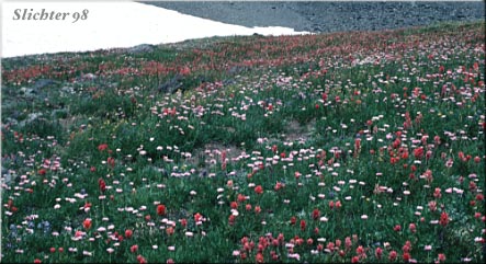
The alpine and subalpine regions of Mt. Adams are typically fairly snow covered until well into June. Peak bloom near timberline generally begins in mid- July, and extends until early September. The winter months find this region covered with several to many feet of snow.
From the South:
From Washington State Road 14 which parallels the Columbia River, turn north on the cutoff road to Highway 141 at the east side of the bridge spanning the White Salmon River. Follow Highway 141 north through Husum, WA and BZ Corners, WA to Trout Lake, WA. The ranger station is at the west end of the main road through town. To get to the southern side of the mountain, the most direct route is to turn north (right) onto forest road 23 at the east end of Trout Lake. Several miles north, the road reaches the forest. Rd #23 turns northwest. Take this road to access the Pacific Crest Trail #2000 and the southwestern side of the mountain. Trail #2000 begins on road #521, which is at the forested saddle just past the spectacular close views of the southwestern side of Mt. Adams.
Morrison Creek and Cold Springs Campgrounds provide a good base camp for day long explorations of the southern slopes of Mt. Adams. Both can be reached from Trout Lake by driving north on Forest Road #23. As the forest is reached, continue straight on Rd #80 instead of veering left on Rd #23. Rd #80 is paved at first, but soon after it becomes gravelled, it becomes Rd #8040. This road is in decent shape, although it may be fairly wash boarded in places to Morrison Creek Camp Ground. Botanists on horseback may also camp at the near by Morrison Creek Horse Camp. To continue on to the smaller, more primitive Cold Springs Campground, turn right onto forest Rd # 500 which begins at Morrison Creek C.G.. This is a primitive road and care must be taken if you are driving a low slung car, especially full of passengers. The road is barely one lane, deeply rutted in spots, and one must not only watch where these ruts are to avoid high centering, but one must also watch for vehicles approaching from the opposite direction.
To access the Gotchen Creek Trail, proceed north out of Trout Lake via Rd #23, proceeding straight first onto Rd #80, then after about three miles or so, veering right onto forest Rd #8020. Continue on gravelled Rd #8020 for several miles. This eventually turns into forest Rd #150. This will take you to the Gotchen Creek #11 trailhead to be seen on the left of the road after several miles.
To reach Bird Creek meadows, leave Trout Lake via Rd #23 as above, then onto #80. After about one-half mile, veer right onto Rd #82. At a point where the pavement ends, turn right and continue on Rd #82. As Rd #82 enters the Yakima Indian Reservation, it will veer north at an intersection, and becomes Rd #8290. One can visitMirror and Bird Lakes, using both as starting points for trails leading to the actual meadows higher up, or one can continue on Rd #8290 about another mile to a small parking lot at a saddle on the ridge above Bench Lake. This is the eastern end of the Round the Mt. Trail. Hike west about a half mile to reach some of the meadows. You can continue further west on the trail to view other fantastic flower displays, or hike north and uphill on a loop trail to the spectacular view at Hellroaring Overlook. Meadow wildflowers and those found in sandy alpine habitats may be seen on this latter trail.
Access to Mt. Adams may also be attained from the west via Road #90 which runs to the south of Mount St. Helens National Monument. Check to make sure this road is open after heavy rains, as flooding has occasionally wiped out bridges along this route. This route gives more direct access to the northwest and southwest sides of the mountain, and is the only road that is paved most of the way to the mountain. Consult a map for the most direct route to the area you wish to visit.
From the north, one may arrive at Mt. Adams by driving to Randle, WA (from Yakima in the east and Interstate 5 in the west) and turning south on Forest Road #23 and proceeding south to the southern side of the mountain (this may take several hours, especially if you do like I do......stopping to look at everything enroute! This route gives more direct access to the northwest side of the mountain, especially if you are arriving from Puget Sound or Yakima.