[Wildflower Hikes of Northern and Northeastern Mt. Adams]

Wildflower Hiking Potato Hill

Gifford Pinchot National Forest and Yakama Nation Lands

This photo shows Potato Hill as seen from the parking area of the Trailhead for the Pacific Crest Trail #2000 on Road #5603. The Pacific Crest Trail veers left and proceeds along the western base of Potato Hill, and there is no organized trail to its summit. The right portion of Potato Hill (eastern slopes) are on Yakama Indian Reservation lands.......June21, 2005.

This photo shows Potato Hill as seen from the parking area of the Trailhead for the Pacific Crest Trail #2000 on Road #5603. The Pacific Crest Trail veers left and proceeds along the western base of Potato Hill, and there is no organized trail to its summit. The right portion of Potato Hill (eastern slopes) are on Yakama Indian Reservation lands.......June21, 2005.

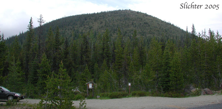
Note: The eastern half of Potato Hill is Yakama Nation lands. The boundary is poorly marked by several widely-spaced metal stakes. Please make an effort to stay off their lands. In addition, since my visit nearing 20 years ago, the timber on this old cinder cone has grown considerably taller so any views of the surrounding scenery will be minimal.

Access to the Trailhead:

From Trout Lake: Drive north on Road #23 25.6 miles to a junction with paved Road #2329. Proceed right on Road #2329 for 11 miles until its junction with paved Road #5603. Turn right at this junction and proceed uphill for over a mile until you reach the signed crossing of the Pacific Crest Trail #2000. Park in the small lot on the north side of the road.

From Seattle, Tacoma, Yakima and Portland: Proceed to Randle. Proceed south of Randle on State Route 131 for 0.9 miles. Turn left (east) onto forest Road #23 and proceed uphill to the junction with Road #2329 where you will turn left and proceed as mentioned above. You can also access the Potato Hill Trailhead from road 56 and then turning right onto Road #5603 and following it to the trailhead.

Low Elevation: ~4750' (GPS: )

High Elevation: 5387' (~GPS: )

Elevation Gain: 637'

Length of Hike: about 1 1/2-2 miles round trip, depending on your cross country route.


Proceed north on the Pacific Crest Trail on an old road bed for about one-quarter mile until the trail reaches the western base of Potato Hill and turns towards the northwest. At this point, veer right, traversing the slopes of Potato Hill to its summit. Note that the southern and eastern slopes are more open than the timbered western and north slopes. Hike with caution up the sideslopes which are steep. There is a depression at the summit which opens towards the west, with a small pumice meadow to the west and denser coniferous forest on the east side of the floor of the cone. It is probably easiest to traverse around the south and eastern rim of the cone.

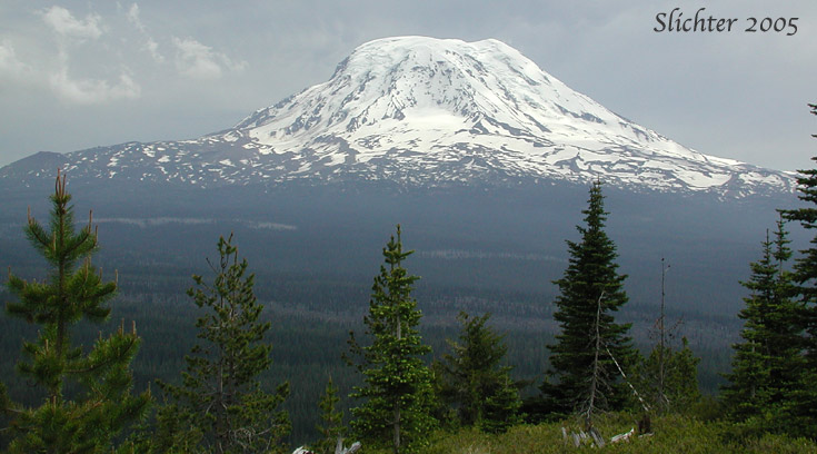
Views from the summit area extend southwest towards Council Butte and the Dark Divide, south to the looming presence of Mt. Adams, and eastwards into the upper Klickitat River basin. Views to the northeast give fairly close views of the eastern portions of the Goat Rocks. The summer encampments of the Yakamas (I'm assuming these are used to pick berries) may be views at the eastern base of Potato Hill. On days with low cloud cover, Mt. Adams appears as a large rounded island floating on a cloudy sea. During weekdays, an occasional log truck hauls logs from logged areas on the northeastern slopes of Mt. Adams along Road #5603 viewed below.


Plant Lists:

July 12, 2005: Potato Hill - Accessed via Pacific Crest Trail from trailhead on Forest Rd. 5603

June 21, 2005: Potato Hill - Accessed via Pacific Crest Trail from trailhead on Forest Rd. 5603


This photo shows the northern slopes of Mt. Adams as seen from the summit of Potato Hill which is about midway between Mt. Adams and the Goatrocks.

This photo shows the northern slopes of Mt. Adams as seen from the summit of Potato Hill which is about midway between Mt. Adams and the Goatrocks. Proceeding from the right, one can see the cascading Adams Glacier, Lava Glacier (at center, at the base of the mountain), and the twin lobes of the Lyman Glacier, as well as the snow-free terrain of the Devils Gardens (left horizon) and Red Hill (on the horizon at left). Photographed June 21, 2005.

Paul Slichter