Ochoco N.F.
From Prineville, OR, drive east along US Highway 26 for about 17 miles and then turn right at a fork in the road that is signed "Ochoco Creek" and Ochoco Ranger Station. Proceed along this paved road (County Rd 23) for about 8.2 miles, watching for deer and pronghorn before reaching the ranger station. At 0.2 miles past the ranger station, turn right onto paved Forest Road #42. Drive upwards through open Ponderosa Pine forests for about 7 miles until a pass is reached. Nice penstemons can sometimes be found along the road here. Sorry, but I don't recall which species they are. Proceed downhill on FS Rd #42 past the Amity Mine to reach the western edge of Big Summit Prairie. An intersection with FS Rd 4210 (gravel) is soon reached. Turn left on this road if you wish to explore the northern fringes of the prairie, or continue on paved FS Rd #42 to explore the southern edge of the prairie.
From John Day, OR, drive west along US Highway 26 for about an hour or so, proceeding uphill past the John Day River and eventually reaching a signed road to the south which is Forest Service Rd #12. Proceed uphill through rangeland several miles before passing Barnhous Campground at the forest boundary. Upon reaching Forest Road #30, turn right (west) and proceed on this road for about one-half hour before descending to the eastern edge of Big Summit Prairie. At the east edge of the prairie, you will reach a "T" in the road. Turn left on what is still FS Rd #30 if you wish to explore the southern part of the prairie. Turn right onto FS Rd #3010 if you wish to explore the northern portion of the prairie. If you turn south, you will shortly reach Forest Rd #42. Turning left (east) on this road takes you through a beautiful open forest along the North Fork Crooked River. Turning right will lead you along the southern edge of the prairie and eventually to Ochoco Ranger Station and from there, west to Prineville.
Most of Big Summit Prairie is in private ownership, with only parts of the fringe of the prairie in public ownership. Consult the Ochoco Forest map or watch for private signs. I look for plants that like drier, rocky habitats along Forest Rd #30 on the east side of the prairie. Such plants include many of the desert parsleys, Allium tolmiei, Gilia aggregata, etc.. Look for showy Wyethia helianthoides, Besseya rubra, Valeriana edulis, shooting stars and many other species in the wet meadows astride Forest Rd #42 at the southern edge of the prairie. At the intersection of FS Rd 42 & FS Rd 4210, you should find Penstemon gairdneri. Turn south on FS Rd 4210, proceeding about a mile, crossing Jungle Creek and passing over a cattle gate into forest land. Park at a turnout (campsite) and walk out into the meadows lining the North Fork Crooked River. Look for several species of clover, Viola adunca, several species of groundsel, several species of paintbrush, and Dodecatheon pulchellum (both pink and white). A low rocky ridge to the north can be explored for bitterroot and other plants that desire dry habitats. The flats to the north of this ridge also contain a different collection of plants, including Arnica sororia and Happlopappus languinosus ?. See the plant lists below for more details.
Most meadows in this area can be explored if you aren't able to find the site I've listed above.
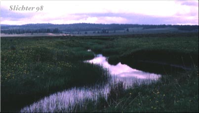
At the western edge of Big Summit Prairie, FS Rd 42 parallels Johnson Creek. There should be large samples of Saxifraga oregana and large paintbrushes to be seen. The forest and riparian habitats can be explored for wildflowers and birds in this location.
Scan Big Summit Prairie at every stop for sitings of the numerous pronghorn and mule deer that can be found here.