Malheur National Forest
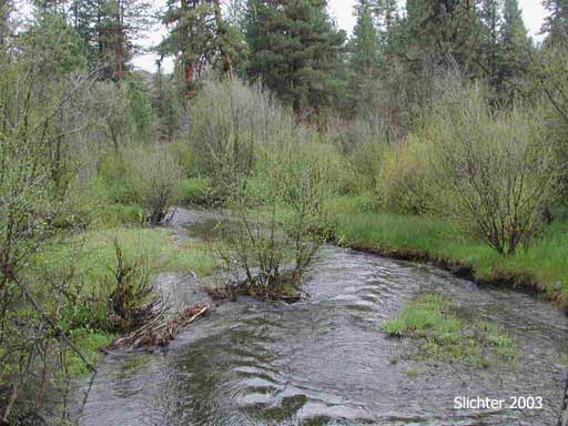
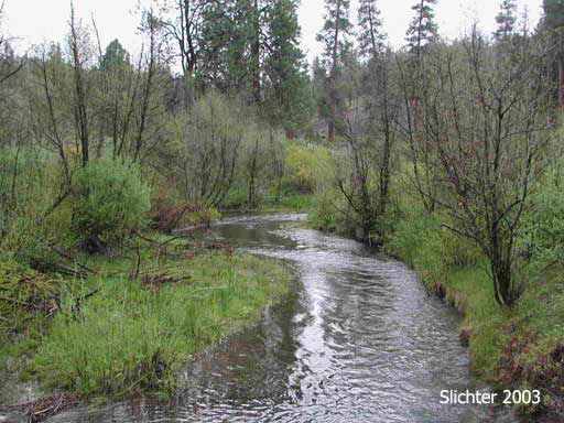
Murderers Creek is a small creek that runs east and west along the southern base of the Aldrich Mountains in the western Malheur National Forest. Because of the open meadows between the main road and the stream, it is a popular destination for local campers and hunters. Much of its length has been revegetated and restored so it is often mentioned as a first rate salmon stream. Many birds of riparian areas can be seen in the willows lining its banks, and birds of the surrounding coniferous forest can often be observed flying in for a drink. While driving through, always be on the look out for deer, elk and wild horses.
Drive west from John Day, OR on US Highway 26 for approximately 18 miles to a junction with Forest Service Road FS Rd 21. Drive south on paved FS Rd 21, crossing the pass and descending several miles to a major T junction. FS Rd 21 continues to the left (east) and can be used to access the upstream portions of Murderers Creek. To reach the lower section of the Creek, turn right onto gravel FS Rd 2170. Drive west about a quarter of a mile to Oregon Mine Campground, a small forest camp with several campsites and a primitive pit toilet (bring your own TP). Several sites abut Murderers Creek and most are under the shade of several large ponderosa pines that are scattered across the campground. There are numerous spots to camp along the creek upstream of the campground. Just pull off the road and drive 100' across the grassy meadows to the campsite you desire. All should provide access to good trout and salmon/steelhead fishing when in season. One can park at the campground and then walk upstream or downstream along the road or where possible, along the stream. Downstream along FS Rd 2170 (on the north road shoulder) about 200 meters, one will find a small wetland with interesting plants to explore. Uphill and behind the wetland you will find a rock outcrop with additional interesting plants. Road 2170 can be explored further downstream but as you near the western forest boundary, the road gets much rougher and it is recommended that low slung passenger vehicles proceed beyond that point at their own risk.
A short distance west of Oregon Mine Campground, FS Rd 2490 crosses the creek and veers south from FS Rd 2170. Follow it west to the Shaketable Reserach Natural Area for a cross country hike last just a few hours or even the full day. An alternate destination is to drive west on FS Rd 2490 and then veer south on spur road 228 which climbs the forested side of Blue Ridge. At the summit of the ridge, one can find a place to park and then hike east for several hours along the mostly open ridgetop.
An alternate route to access Murderers Creek is to drive south on US 395, passing the summit and descending to the north end of Bear Valley. Turn west onto paved Grant County Rd 63 and drive west several miles before turning right (north) onto FS Rd 21. FS Rd 21 is paved but narrow with occasional turnouts. After several miles, one can turn right (north) onto FS Rd 2190 which leads to the trailhead for the Riley Creek Trail #216A which affords access to McClellan Mt and the high country of the central Aldrich Mts. Or proceed further west along FS Rd 21 looking for places to stop and explore, eventually reaching a large clearing on the north side of the road at the junction of FS Rd 2170 and the section of FS Rd 21 that heads north to US 26.
Partial Plant List for Oregon Mine Campground and Adjacent Murderers Creek
July 14 & 15, 2003: Vicinity of Oregon Mine C.G., Malheur N.F.
June 23, 2003: Oregon Mine Campground, Malheur N.F.
May 24, 2003: Forest Road #21, Malheur National Forest
May 23, 2003: Oregon Mine Campground along Murderer's Creek, Malheur N.F.